
Very nice card from Georgia River Network about Paddle Georgia (facebook):
Category Archives: River

Paddle the Alapaha at US 82 2PM Saturday 27 July 2013
Join WWALS on our monthly outing, on the exotic Alapaha River:
Jungle-like in its remoteness and luxurious with exotic vegetation, the dark reddish-brown waters of the Alapaha wind through a swampy wonderland teeming with wildlife. — Alapaha River Paddling Guide, by Suzanne Welander
Yet it’s right here in Berrien County, Georgia, only an hour’s drive from Valdosta and less from Adel, Lakeland, Tifton, etc.
Meet at the intersection of Hwy 82 bridge and the Alapaha River, about 2 miles east of Alapaha, GA.

Park cars at the top near a derelict brick building (south of highway). There is a road down to the river but it is badly washed out so you probably want to take a look before you drive down.
We’re planning to paddle upstream a ways and then float back down.
Join the facebook event or just come paddle!
-jsq
Streamer on the Suwannee, Alapaha, and Withlacoochee Rivers: ten or more rivers and many creeks, lakes, swamps, and ponds
Update 3 March 2016: Suwannee River, ten rivers, and current location of USGS streamer.
The USGS Streamer interactive map shows all (well, most) tributaries of our two biggest WWALS rivers. Visitors sometimes refer to our “four rivers” since we only originally named four in our WWALS mission: Withlacoochee, Willacoochee, Alapaha, and Little. Yet we added the upper Suwannee, and there always were more than that: from one to ten rivers, depending on how you count them.
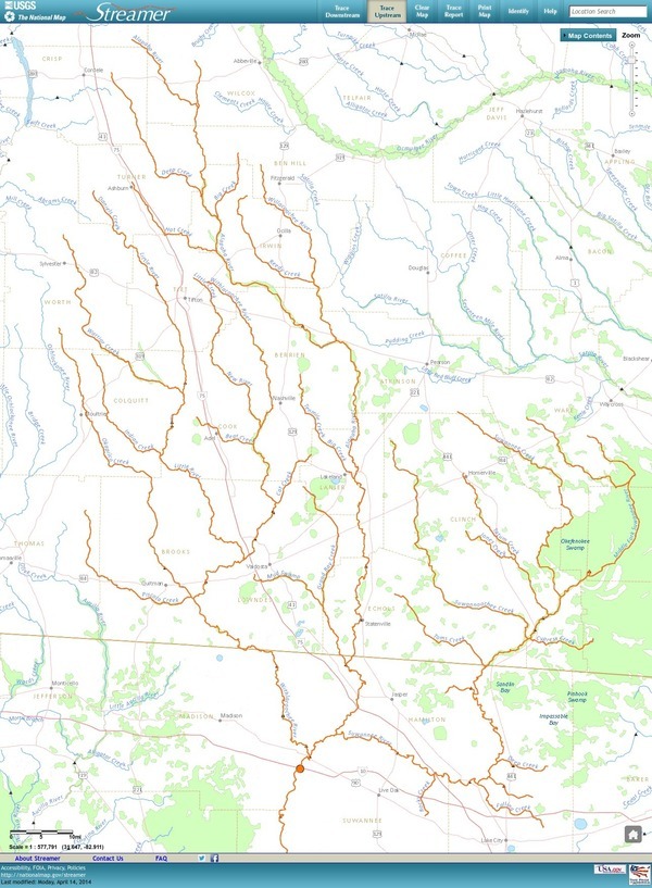
The Withlacoochee River tributary map here shows the New River south of Tifton joining the Withlacoochee between Nashville and Adel.
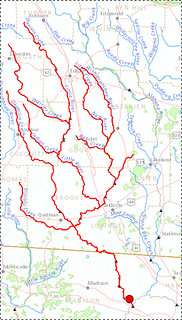
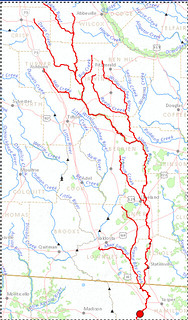
The New River is rather important, since it forms half of the boundary between Cook and Berrien Counties (the Withlacoochee River forms the other half): Continue reading
Agricultural runoff
The Southern Georgia Regional Commission invites you to contact them about agricultural runoff. WWALS is concerned with how industrial farming and clear cutting affects both water quality and quantity in our watershed.
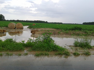 The pictured example of runoff from a cotton field was in Berrien County
yesterday.
While rain was pouring down, it ran half way across the road, and
two cars wrecked.
Once it gets across the road, either over it or through the culvert,
it runs into the Withlacoochee River.
As Pesticide Action Network reminds us,
“Conventionally grown cotton uses more insecticides than any other single crop.”
The pictured example of runoff from a cotton field was in Berrien County
yesterday.
While rain was pouring down, it ran half way across the road, and
two cars wrecked.
Once it gets across the road, either over it or through the culvert,
it runs into the Withlacoochee River.
As Pesticide Action Network reminds us,
“Conventionally grown cotton uses more insecticides than any other single crop.”
Abbie Fentress Swanson wrote for GPB 6 July 2013, What Is Farm Runoff Doing To The Water? Scientists Wade In,
Agriculture is the nation’s leading cause of impaired water quality, according to the U.S. Environmental Protection Agency.
Continue reading
Withlacoochee River at Camp Tygart 2013-07-08
Kind of high (movie):

Picture and video by John S. Quarterman for WWALS Watershed Coalition (WWALS),
Berrien County, Georgia, 8 July 2013.
-jsq
Withlacoochee River from Nankin Landing to GA 31: WWALS June Outing 2013-06-22
A few pictures from today’s WWALS Outing on the Withlacoochee River from Clyattville-Nankin Road to GA 31, with 12 people in 8 boats (4 kayaks, 4 canoes).
Gage height, US 84 Quitman: 3.25 feet (86.75 feet NAVD 1988).
Withlacoochee River at Clyattville-Nankin Landing:
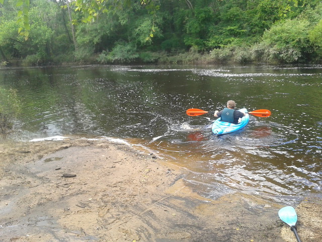
Heather sets out:
Withlacoochee River Outing: Clyattville-Nankin Road to GA 31
The June WWALS outing is from Clyattville-Nankin Road to Horn Bridge on
 Madison Highway (GA 31) on the Withlacoochee River.
Meet at the Clyattville-Nankin Road putin at 9AM, put in at 10AM, Saturday, 22 June 2013.
Join the
facebook event if you like.
See you there!
Madison Highway (GA 31) on the Withlacoochee River.
Meet at the Clyattville-Nankin Road putin at 9AM, put in at 10AM, Saturday, 22 June 2013.
Join the
facebook event if you like.
See you there!
Update 20 June 2013: How are we getting back to our vehicles with this trip? We’ll deposit all the boats at the put-in (Clyattville-Nankin Road), take most of the vehicles down to the take-out (Horn Bridge on Madison Highway aka GA 31), carpool in a few vehicles back to the put-in, and float down the river.
Tom Baird described this nine-mile two-hour trip as:
The section includes where Clyatt Mill Creek enters, a truly fun set of rapids (two drops) at the Ga – Fla border, a very nice Second Magnitude Spring (that I have yet to find the correct name), the remains of the enormous abandoned trestle over the river of the Georgia & Florida Railroad,or Ole God Forsaken as it was nicknamed, the ghost town of Olympia on the Georgia side, and several Indian quarry sites. It is along this section that the river cuts deeply enough that the banks switch from sand banks to limerock cliffs. Paddle distance is about 9 miles, so a little over two hours paddling time. There are plenty of places to stop and look around.
There are shoals right at the state line, so beware, esp. if you’re in a canoe. The book Canoeing and Kayaking Georgia, by Susanne Welander, Bob Sehlinger, and Don Otey (2004) says: Continue reading
Ask Georgia Power to conserve our water –WWALS to GA PSC
Approved 12 June 2013 by unanimous vote of the WWALS board, Dave has mailed a signed copy to the Georgia Public Service Commission, and I will go read it to the PSC Tuesday morning at 10 AM 18 June 2013, at their hearing about
Docket 36498, Georgia Power Company’s 2013 Integrated Resource Plan and Application for Decertification of Various Unitsand
Docket 36499, Application for the Certification of Amended Demand Side Management Plan
Y’all come! -jsq
From: WWALS Watershed Coalition, Inc.
3338 Country Club Road #L336
Valdosta, GA 31605
12 June 2013To: Georgia
Public Service Commission
244 Washington Street, SW
Atlanta GA, 30334-9052
Dear Public Service Commissioners and Staff,
The recent rains have swollen our blackwater rivers, Withlacoochee, Willacoochee, Alapaha, and Little, under our longleaf pines and Spanish-moss-covered oaks, and filled up the tea-colored tannin waters in our frog-singing pocosin cypress swamps here in central South Georgia. But that was only a dent in our protracted drought that ranges from mild to extreme, with projections not much better.

We do not need more traditional big baseload power plants gulping down our river or aquifer water when solar and wind power use far less, and those renewables are now at grid parity with coal, natural gas, and nuclear.
Power plants are thirsty, as the Union of Concerned Scientists pointed out in a 2011 report, “Freshwater Use by U.S. Power Plants: Electricity’s Thirst for a Precious Resource”.
Much of the water used to cool power plants evaporates, and is Continue reading
George Vellidis Dissolved Oxygen Slides
PDF of Dissolved Oxygen Dynamics in the Upper Suwannee River Basin by Prof. George Vellidis, Crop & Soil Sciences Dept., University of Georgia, Tifton, GA. He used these slides when he discussed the dynamics of dissolved oxygen concentrations in WWALS waterways at the 8 May 2013 WWALS board meeting.

More later.
-jsq
