
Withlacoochee River at US 41

Flooding at Valdosta, 2016-04-04
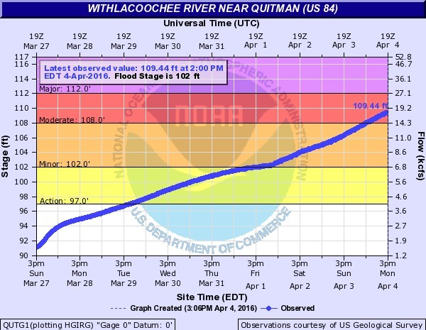
Wondering why Valdosta is having an overflow problem? It was rain on Valdosta, and north of Valdosta.
Not so much northwest on the Little River, nor even west on Okapilco Creek: Continue reading
More Valdosta wastewater spills over the weekend; stay tuned 2016-04-04
Update 2016-04-05: Here are the details, and force main and new WWTP on line by May.
Valdosta spilled more wastewater over the weekend,
according to Valdosta City Council Tim Carroll, who called just now.
 The Withlacoochee River is out of its banks, actually up on the property containing the Withlacoochee Wastewater Treatment Plant (WWTP), but “according to the experts” not going to threaten the plant. “But lines are underwater”.
Water is not even close to the new WWTP currently under construction, according to Carroll. And the new force main project should deal with much of the manhole overflow problem on the west side of Valdosta in the Withlacoochee basin, for example into Sugar Creek.
On the east and southeast, in the Alapaha basin, Continue reading
Ray’s Mill Pond, 2016-04-02
See you 9AM tomorrow morning April 3rd for the
WWALS Outing at
the 3,500 acre Ray’s Mill Pond,
 which is open for boating 24/7; just put a dollar in the box.
In the evenings Monday thru Thursday, don’t park your boat on the pavement
because the restaurant is open then, and it’s very popular,
but no worries on a Sunday morning.
which is open for boating 24/7; just put a dollar in the box.
In the evenings Monday thru Thursday, don’t park your boat on the pavement
because the restaurant is open then, and it’s very popular,
but no worries on a Sunday morning.
You can join this fun and work by becoming a WWALS member today!
-jsq
You can join this fun and work by becoming a WWALS member today!
View from boatramp

Deposit .00 Launch Fee Here

Launch Fee .00

No Boat Trailers on Paved Lot Thursday Thru Saturday 4PM til 10PM

Busy restaurant parking lot

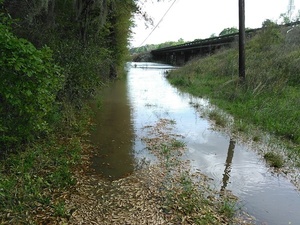
Cat Creek flooding

Rays Mill Pond spillway

View from walkway
Cat Creek flooding
At Ray City

Possum Creek flooding

Blue Spring and McIntyre Spring, Withlacoochee River, Brooks County, GA, 1903-11
Update: 4610-foot explored cavern under McIntyre Spring.
Blue Spring between Quitman and Valdosta has been known since the settling of Brooks County, when it was used as a reference point in building roads starting in 1859. Here’s an early 20th century report, with a much later picture postcard (probably not the same building) and location map.

A Preliminary Report on the Underground Waters of Georgia, by S. W. McCallie, State Geologist, Continue reading
Sinkhole Trail on the agenda, Suwannee BOCC, 2016-04-05
Once again, Suwannee County follows Hamilton County’s lead.
Carl McKinney, Suwannee Democrat, 1 April 2016, Suwannee County Commission to discuss Sabal Trail sinkholes,
At its next meeting, the commission will consider sending a letter to the U.S. Army Corps of Engineers, which must issue a permit for the pipeline project.
The letter would mimic one Hamilton County recently voted to send, said Suwannee County Commissioner Wesley Wainwright.
Wainwright asked Continue reading
Little River at GA 37
 The Little river is not out of its banks here but, close. The river is moving swiftly.
cjm
That’s at Cook County Landing, with 10.95 (184.05) feet upstream at the Adel Gage and 15.10 (147.90) feet downstream at the GA 122 Little River gage. This is below flood stage (16 feet and 19 feet, respectively), with water levels falling.
-jsq
Withlacoochee River US 41 just before flood, 2016-03-31
Sunday there was parking under the bridge, now that’s under water.
 The intended put-in for
this Sunday’s Withlacoochee Outing,
is just downstream from here, so we’re rescheduling that one for
Ray’s Millpond,
875 Rays Mill Pond Rd., Ray City, GA 31645,
still 9AM March 20th 2016.
Directions: From Valdosta, north on Bemiss Road (GA 125) to Ray City, right on Jones St. to boat ramp.
The intended put-in for
this Sunday’s Withlacoochee Outing,
is just downstream from here, so we’re rescheduling that one for
Ray’s Millpond,
875 Rays Mill Pond Rd., Ray City, GA 31645,
still 9AM March 20th 2016.
Directions: From Valdosta, north on Bemiss Road (GA 125) to Ray City, right on Jones St. to boat ramp.
It’s 14.75 feet, just below 15 foot flood at the Continue reading