Tag Archives: Alapaha

WWALS at Alapaha Celebration Days

WWALS will have a booth at the annual Alapaha Celebration Station in Alapaha, Georgia, tomorrow, Saturday Nov. 8th 2014. The festival theme this year is Alapaha River Days. See you in downtown Alapaha tomorrow, at 245 NE Railroad Street, 31.381532,-83.223416, just east of Main Street, US 129.

Mission of WWALS Watershed Coalition, Inc.: Continue reading

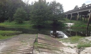
Alapaha River access at Hwy 82 at very low water

300x179 The cement strip boat ramp is uneven, in Alapaha River access at Hwy 82 at very low water, by Bret Wagenhorst, for WWALS.net, 14 September 2014 Pictures of the location of the Alapaha River Cleanup at US 82, 27 September 2014, taken east of the town of Alapaha at US 82 on the Alapaha River by Bret Wagenhorst.

And this access point is on the Alapaha River Water Trail WWALS is developing.

Continue reading

Georgia Rivers Environment Issues.

20140202-215732.jpg

Georgia’s environment regulators urged keep hog waste out rivers.This article is by Jennette Gayer who work with Environment Georgia Advocate. Georgia’s Environmental Regulators have proposed serious rollbacks to existing rules that protect Georgia’s waterways from pollution created at large industrial hog operations. At a public hearing held by the Enviornmental Protection Division on October 25th, 2013 Environment Georgia’s State Advocate Jennette Gayer offered the following as public testimony. “Water quality in Georgia will continue to suffer if the swine and hog threshold is increased from 3000 to 5000 animal units as proposed, and those facilities are not required to obtain individual National Pollution Discharge Elimination System permits (NPDES). If we know – and we do know based on historic examples – that these operations can discharge to and impair waters, why is the state making it easier for these operations to function with less oversight? In addition to being charged with regulating CAFOs, EPD is also charged with assessing the water quality of our state’s waterways, identifying the impairments, and where impairments exist – addressing those problems to clean up the streams and creeks Georgians fish in, swim in and drink from. I want to provide a few quick examples of water segments and reaches where permitted swine operations have been determined by EPD studies to be negatively affected by animal production facilities. I’ve pulled this information from Georgia EPD’s 2012 305(b)/303(d) List Documents, Total Maximum Daily Load (TMDL) Implementation Plans, and permitting data.[1] Seven swine operations that had individual NPDES permits were immediately upstream or adjacent to state waters in the Savannah, Withlacoochee, Alapaha, Ogeechee, Canoochee, Oconee and Ocmulgee basins that do not support their designated use. The designated uses of these streams is fishing, and the primary reason for impaired waters is fecal coliform contamination, low dissolved oxygen levels, or non-point sources. In these watersheds, that fecal coliform and non-point sources are typically associated with agricultural operations. Rather than rolling back safeguards for Georgia’s waterways we should be investigating these examples of pollution near existing Hog CAFO’s and working to solve them. I urge you to act in the best interest of Georgia’s waterways and not move forward with this rule change.” [1] Georgia Water Quality Standards are connected by three components. Every water body in Georgia has one of six designated uses: fishing, drinking water supply, recreation, coastal fishing, wild river, and scenic river. And each of those designated uses must meet specific water quality criteria (such as dissolved oxygen or bacterial levels). Finally, the Clean Water Act has an anti-degradation component which is designed to protect existing designated uses and water quality. In other words, water quality is not allowed to degrade and threaten the designated use. And a downgrade in designated use “is prohibited if it would remove protection from any existing use.” (River Network) EPD is required by the Clean Water Act to assemble a list of creeks, streams, rivers and lakes that do not meet water quality standards. EPD uses the list – which is created every two years – to target areas for restoration and to remove water bodies from the list (de-list) where water quality has improved. If a water body is impaired and the designated use is threatened, EPD can place the water body on the 305b/303d list of waters. EPD can develop plans – such as a Total Maximum Daily Load (TMDL) – to improve water quality. Furthermore, the data can help EPD assess the state of a specific water body that is or might be affected by a new or renewed National Pollutant Discharge Elimination System (NPDES) permit, water withdrawal permit, or other permit that might affect designated uses and water quality standards. -CLG

Alapaha River at Statenville: January WWALS Outing

Meet at the boat ramp/parking lot on the left just before you get to Statenville heading east on Hwy 94 at 1:30. Boat launch is at 2. We will paddle upstream for 30 to 45 min. and then float back down. The river will likely be up, so it should be a work out.

The river water temperature is currently 50 degrees Fahrenheit, so dress warmly. The Alapaha River at Statenville is currently at 9 feet and rising, which is well above the level recommended by Brown’s Guide for this river.

Jungle-like in its remoteness and luxurious with exotic vegetation, the dark reddish-brown waters of the Alapaha wind through a swampy wonderland teeming with wildlife. Signs of habitation are rare along the river’s course; only a few isolated cabins intrude on the remote tranquility.

Here’s a map: Continue reading

Entering the Floridan Aquifer Recharge zone –Kristofer Graham

Written as a newspaper letter to the editor and posted here with permission. -jsq

Dear Residents

Did you know Lanier County doesn’t have zoning laws. Which that mean they can development on wetlands and on our Floridan Aquifer Recharge zone and build resident houses, subdivided, commercial building etc., cut timber on wetlands, on our watersheds and a Natural Gas Company want to put a pipeline through on these precious lands they can. It will destroy the land environment like our Floridan Aquifer Recharge zone (aka our drinking water) and our wetlands and our watersheds. Because it not protected like it should.

Lanier County Groundwater Recharge Areas Well it time to protect it before it all destroy and gone. It is up to our local government to protect these precious lands and preserve it in the original state. Yes it’s time for our local government to do there job to protect it. So it can be there forever.

I notices they got those lands zone as Ag and V5 zone. Which those zone doesn’t protect it and in fact it can destroy those lands Eco system because they spray pesticide for there farm crops near the Floridan Aquifer Recharge zone and wetlands, our watersheds. It will Continue reading

Ichetucknee Alliance thinks it got the pipeline to move

According to their facebook page today, a conservation group in Florida convinced Sabal Trail to steer clear of their springs. Or did they? The “written assurances” they they got from Spectra’s Andrea Grover say “preferred” and “currently”. In any case, some of Ichetucknee Alliance’s positions are just as valid in WWALS’ watersheds.

Here’s an excerpt from their position, Ichetucknee Alliance Pipeline Position Paper, 21 August 2013, Continue reading

Pipeline would cross Withlacoochee River twice

The detail maps in the General Project Description in the 15 November 2013 update to FERC by Sabal Trail Transmission reveal that the proposed path would cross the Withlacoochee River both where the river is the border of Brooks and Lowndes County and where it is the border between Hamilton and Madison County near Ellaville. In between, the pipeline would run through many wetlands near the river and through quite a few recharge zones for our drinking water source, the Floridan Aquifer. Then it crosses our downstream river, the Suwannee, into Suwannee County, Florida.

Continue reading

Pipeline alternate route still in WWALS watersheds, plus Tifton and Valdosta

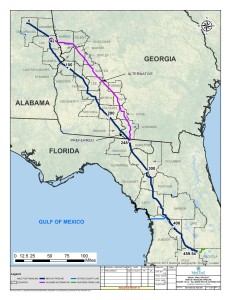
The Hillabee alternative route runs right down the middle of the WWALS watersheds, through Worth County, Turner County, Tift County, Colquitt County, Cook County, and Lowndes County in Georgia, and Hamilton County, Madison County, and Suwannee County in Florida. This puts it not only still in the Withlacoochee River watershed, but also in the Little River and Alapaha River watersheds. This route by the pipeline company Sabal Trail Transmission (owned and managed by Spectra Energy) avoids Albany but apparently goes through Tifton and Valdosta and still through Lowndes County before entering Florida in Hamilton County much like Spectra’s preferred route.

Hillabee (Valdosta and Tift County) Route Alternative, Georgia

This alternate route is the rest of the Option B that was first proposed to Lowndes County residents back in June: Continue reading

WWALS files as intervenor to oppose the Sabal Trail Transmission gas pipeline

Approved by the WWALS Board 13 November 2013. PDF.

From:
WWALS Watershed Coalition
3338 Country Club Road #L336
Valdosta, GA 31605
www.wwals.net
wwalswatershed@gmail.com
18 October 2013

To:
Secretary Sarah McKinley
The Federal Energy Regulatory Commission
888 First Street N.E
Washington, DC 20426

Re: Pre-filing Docket PF14-1 Sabal Trail Transmission

Cc:
Georgia Public Service Commission
Florida Public Service Commission

WWALS Watershed Coalition, Inc. opposes the proposed Sabal Trail Transmission gas pipeline that would cut a 100 foot wide gash across our Withlacoochee River and through many wetlands in south Georgia and north Florida, including recharge zones for the Floridan Aquifer that provides our drinking water.

Sabal’s parent company, Spectra Energy, has a safety record that gives no comfort Continue reading

Waycross Superfund site in Georgia’s Dirty Dozen

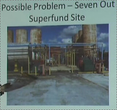
EPA will be in Waycross 24 November 2013 to meet about this contamination, which has also been shipped over into WWALS watersheds. -jsq

Satilla River: Toxic Legacy in Waycross Needs Further Investigations, Cleanups, in Georgia Water Coalition’s Dirty Dozen 2013,

Satilla River

Toxic legacy in Waycross Needs Further Investigations, Cleanups

Introduction:

Lurking within Mary Street Park, a tree-lined neighborhood park in Waycross, is a silent killer—toxic pollutants from a defunct industrial wastewater treatment facility known as Seven Out Tank. Opened in 2002, the industrial waste handler operated only two years before multiple environmental violations led to the facility’s closure. Now, after Continue reading