
For more pictures and a video, see other post.

For more pictures and a video, see other post.
From Florida Bulldog to a daily with more than 140,000 circulation.
Dan Christensen, Miami Herald, 16 August 2015,
Pipeline company with tie to Gov. Scott and state backing, has history of accidents,
Spectra Energy, the company that state environmental regulators say should be allowed to construct a 267-mile-long natural gas pipeline in North Florida, has a checkered history of accidents and violations of federal safety rules in the U.S. and Canada dating back decades.
Do we want to risk Sabal Trail’s fracked methane pipeline blowing out
under the Suwannee or Withlacoochee Rivers like
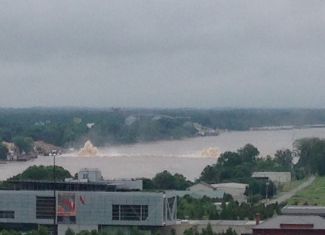 Spectra’s Texas Eastern Pipeline blew out under the Arkansas River in May?
WWALS doesn’t, which is why we filed the
petition to Florida’s Department of Environmental Protection
asking them not to issue a permit for Sabal Trail.
Spectra’s Texas Eastern Pipeline blew out under the Arkansas River in May?
WWALS doesn’t, which is why we filed the
petition to Florida’s Department of Environmental Protection
asking them not to issue a permit for Sabal Trail.
The Little Rock blowout is one of several recent Spectra incidents Dan Christensen finds today in FloridaBulldog.org, Pipeline company with tie to Gov. Scott, and state backing, has history of accidents, Continue reading
This went out yesterday to WWALS members.
TELL GOVERNOR DEAL THAT THE SABAL TRAIL GAS PIPELINE THREATENS PRIVATE PROPERTY, CLEAN WATER, AND HEALTHY COMMUNITIES
Please take immediate action, today, to tell Governor Nathan Deal’s office
that you oppose the siting of Spectra Energy’s Sabal Trail “natural” gas pipeline through the Withlacoochee River watershed. Call 404-656-1776 between 8:30 a.m. and 5 p.m. and tell the staffer that answers, “I am opposed to routing the Sabal Trail pipeline through the Withlacoochee River watershed; I urge Governor Deal to do everything in his power to stop this project”.
Also please sign this petition Continue reading
Update 2021-03-09: The funding cost per gauge has gone up, to $22,500, of which usually the USGS contributes about $900.
How much would it cost
to fund the Okapilco Creek gage so it won’t go offline July 31st?
 About
$13,600/year, more or less, mostly for field and office labor
and administration, with only 10% for the field equipment.
Since this gage is located in Brooks County, Georgia,
the most likely funding body (after USGS itself)
would be the Brooks County Commission.
Yes, it’s in WWALS watersheds; no, WWALS doesn’t plan to take on
funding streamgages. If some funding organization appeared
that wanted to pass the funds through WWALS, which is a 501(c)(3)
educational institution, that would be possible.
But this seems more like a government issue.
About
$13,600/year, more or less, mostly for field and office labor
and administration, with only 10% for the field equipment.
Since this gage is located in Brooks County, Georgia,
the most likely funding body (after USGS itself)
would be the Brooks County Commission.
Yes, it’s in WWALS watersheds; no, WWALS doesn’t plan to take on
funding streamgages. If some funding organization appeared
that wanted to pass the funds through WWALS, which is a 501(c)(3)
educational institution, that would be possible.
But this seems more like a government issue.
In USGS Groundwater Data for Georgia:
The following streamgage will be shut down on July 31, 2015 unless alternative funding can be found:
- 02318700 Okapilco Creek at Georgia Highway 333, near Quitman, Georgia
For questions regarding this threatened streamgage, please contact Tony Gotvald at (678) 924-6648 or agotvald@usgs.gov.
-jsq
Julie Bowland posted on facebook (reposted here with permission):
Continue reading
Paddled for a couple hours this morning around and downstream from the confluence of the Little and Withlacoochee Rivers…just a couple miles from my house. Forgot to bring a canvas so just played with some mixed media drawing. Fun!
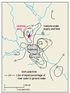 With the artesian level as much as 100 feet above sea level and the land surface
is seldom more than 200 feet, a
Sabal Trail pipeline drilling frac-out wouldn’t
have to go far to get into the Floridan Aquifer
groundwater used by wells around here.
We already saw such water contamination would go underground is
hard to predict.
This is not news: here’s a paper from 1966 with the main points.
With the artesian level as much as 100 feet above sea level and the land surface
is seldom more than 200 feet, a
Sabal Trail pipeline drilling frac-out wouldn’t
have to go far to get into the Floridan Aquifer
groundwater used by wells around here.
We already saw such water contamination would go underground is
hard to predict.
This is not news: here’s a paper from 1966 with the main points.
Artesian Water in Tertiary Limestone in the Southeastern States, By V. T. Stringfield, GEOLOGICAL SURVEY PROFESSIONAL PAPER 517, 1966. Continue reading
Boating on our rivers and water trails for them,
issues and education: 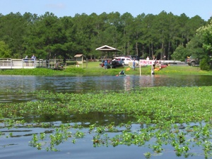 you can help with the fun and work of WWALS!
Here’s much of what can be done laid out in a list of a dozen WWALS Goals for 2015.
The board has at least one opening right now,
and the committees always could use more members. You can apply through the online form.
you can help with the fun and work of WWALS!
Here’s much of what can be done laid out in a list of a dozen WWALS Goals for 2015.
The board has at least one opening right now,
and the committees always could use more members. You can apply through the online form.
See also the monthly newsletter, the news about WWALS, and of course the website with blog, facebook the page and group, and WWALS on twitter, Youtube, and the membership google group. You can become a member or corporate sponsor of WWALS online right now.
The WWALS Executive Committee 11 March 2015 recommended Continue reading
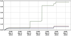 Plus early March rains really were directly on Valdosta,
even more than in Valdosta’s third wastewater spill of February,
yet river levels rose most downstream.
Plus early March rains really were directly on Valdosta,
even more than in Valdosta’s third wastewater spill of February,
yet river levels rose most downstream.
Here are 90-day graphs of precipitation (in inches) and river levels (in feet) at the three Georgia Withlacoochee River gauges, from USGS. Also note river levels can continue dropping even while some new rain falls. Continue reading