Update 2018-12-21: GA-EPD has started publishing online each business day a Sewage Spills Report! So that’s item 1 from the Petition. We thank GA-EPD and we await items 2 and 3.
Update 2018-12-14:
Now plus a petition individuals can sign.
Update 2018-12-12:
Four more Georgia groups make 31: Georgia Women (And Those Who Stand With Us), Atlanta Audubon Society, Chattahoochee Parks Conservancy, and No Ash At All—Wayne County.
![[More Signatures]](https://www.wwals.net/pictures/2018-10-31--ga-epd-spill-resolution/Resolution-Requesting-GA-EPD-to-timely-publish-spill-reports-0003.jpg)
Florida groups: you can sign on, too, like some already have!
Update 2018-11-15:
Three more Georgia groups make 27: GARC, Ogeechee Riverkeeper, and SELC.
Plus slides.

Yes, your organization can still
sign on for further signature deliveries until
we see daily spill updates on the GA-EPD website.
Update 2018-11-12:
Four more Georgia groups make 24:
GA-EPD Richard E. Dunn did answer on November 2, 2018, saying they would look into telling everyone when anyone spills.
Yes, your organization can still
sign on for further signature deliveries until
we see daily spill updates on the GA-EPD website.
Update 2018-11-01:
Now plus Paddle Florida, for six Florida signers and fourteen Georgia signers.
A copy with all twenty signers went today to GA-EPD Director Richard E. Dunn and
Assistant Director Lauren M. Curry. Yes, your organization can still
sign on for later delivery.
Update 2018-10-30: Three downstream Florida groups ask the state of Georgia to tell everyone when sewage gets into Georgia rivers.
To get in the November 1st copy to GA-EPD, sign here by Halloween. Yes, you can still sign on later.
Update 2018-10-18: Two Florida signers makes sixteen so far.
You can still sign here to ask GA-EPD to tell us so we’ll know when they happen.
Update 2018-10-17:
Fourteen signers so far.
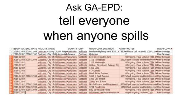
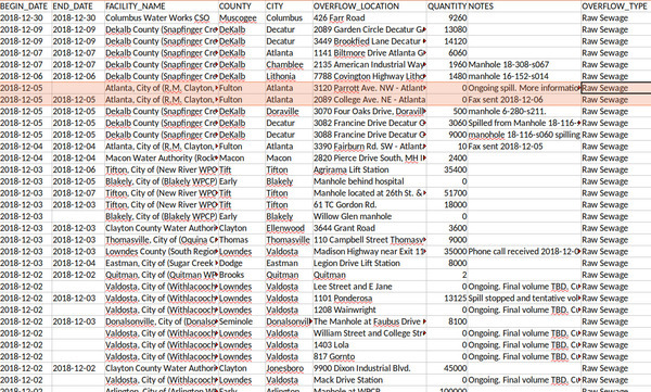
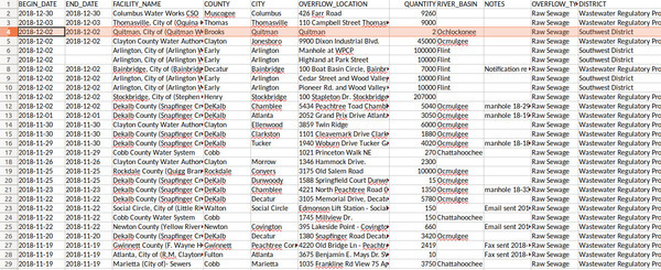
And here are the forty spills since last time.
You can still sign here to ask GA-EPD to tell us so we’ll know when they happen.
Update 2018-09-03:
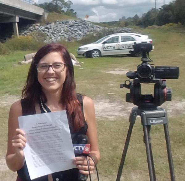
The WCTV report
and the text of the letter establishing the Middle and Lower Suwannee River and Withlacoochee River Task Force.
On WCTV tonight, Emma Wheeler will report about wastewater, Valdosta,
and how at least eight downstream counties in Florida are organizing
about it.
She asked me for suggestions. My suggestions start with: sign
a resolution asking GA-EPD to timely publish spill reports,
and help WWALS with its new
water quality testing program.
And the
Florida Basin Management Action Plans (BMAPs)
could have more effect on the Suwannee River Basin than sewage.
Plus let’s not forget the Tour of Valdosta wastewater treatment plants 9AM tomorrow morning, October 3,
the
WWALS Troupville Boat Ramp Cleanup October 13,
the
WWALS Boomerang paddle race November 3 from Langdale Park Boat Ramp to Sugar Creek and back,
and 300 of our closest friends coming to the Withlacoochee River mid-June 2019
in
Paddle Georgia.
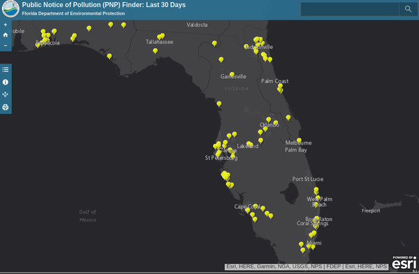
The resolution asks the Georgia Environmental Protection Division (GA-EPD) to do what Florida and Alabama already do:
publish pollution spill reports online the same day they receive them,
with signup for email notices.
The first step in fixing pollution is Continue reading →

![[Brown Dog out, 09:31:38, 30.8484784, -83.3482902]](https://www.wwals.net/pictures/2018-10-13--troupville-cleanup-pictures/20181013_093138.jpg)