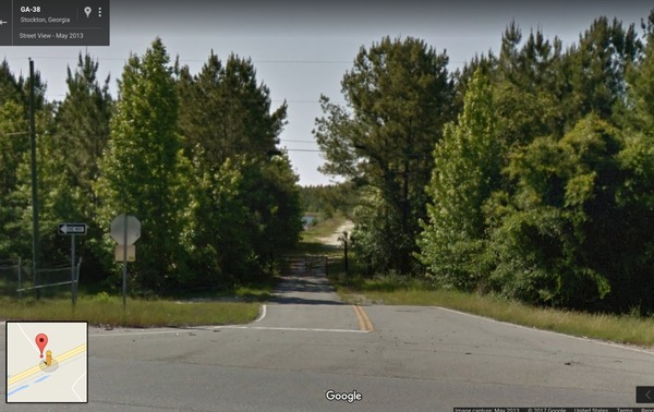
Tag Archives: Hotchkiss Road

Naylor Boat Ramp upstream Alapaha River pictures 2020-06-13

We made it the 1.24 miles upstream from Naylor Boat Ramp to Hotchkiss Road Landing on the Alapaha River Water Trail in the Naylor Boat Ramp Out and Back paddle outing. Very nice weather, cool and overcast, and just enough water in the river.

[Banners]
Photo: Shirley Kokidko for WWALS, Banners at Hotchkiss Road Landing, Alapaha River, 2020-06-13.

First WWALS Trails Committee Chair Dan Phillips planted the new Naylor Boat Ramp ARWT signs.

[Paddlers with signs]
Paddlers with signs

Then we headed upstream. This may be a first: every paddler was already a WWALS member. Continue reading

Lola Tract: WMA in Lanier and Lowndes Counties

Update 2019-05-09: fixed URLs and added map.

It has a name and it is listed: Lola Tract; WMA Stockton:

Offus84
Google Streetview, Lanier County CR 123 off of US 84 aka GA 38.

Lola Tract WMA is a 391 acre property near Stockton. Hunting opportunities include deer, bear, turkey and small game.

This property is only open during hunt dates.

Directions:

From Stockton Take Hwy. 84 west for 1.4 miles. WMA kiosk is on the right. WMA is on both sides of the river.

Voluntary Public Access Area

Continue reading

WMA in Lanier and Lowndes Counties

Yes, it’s a WMA on both sides of the Alapaha River, and it will open for hunting this year. It’s also one of seven or eight, all also Dr. Acree’s land. They will each have names, which are currently unknown, but will pop up in the next few days on the DNR website.

Floating downstream
Photo: John S. Quarterman, 2 April 2017, in Alapaha River, Hotchkiss Road to US 84 2017-04-02

This WMA information is from someone who’s been on site and knows the details, Continue reading

Alapaha River, Hotchkiss Road to US 84 2017-04-02

This was a tiny outing for a couple of visitors from Oregon through what has since become a new Wildlife Management Area on the Alapaha River, between Hotchkiss Road (which had some magnificent potholes) in Lanier County to the site of the pending new park and boat ramp off of US 84 in Lowndes County, Georgia, all on the Alapaha River Water Trail.

Suwannee Riverkeeper banner on the Alapaha River

The visitors were Continue reading

A wonderful Paddle on the Alapaha 2016-04-23

HWY 84 to Mayday.

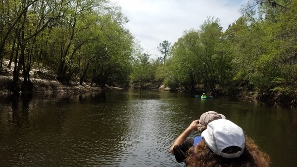
What a great day for a paddle! The current was moving us along nicely, about 12 miles in just under 4 hours. It is a very beautiful stretch of river, very wild, many birds could be heard in the forest canopy.

cjm

This was the Hotchkiss Road to Mayday Outing.

More from Chris’s details in the Outings spreadsheet:

Hotchkiss road was washed out, put in at Naylor park property. Cut about .5 mile off of the trip.

Water level 85 on the Statenville gage. Was in the banks and moving quick. Would not recommend paddling at levels much higher than this.

Features: canopy over much of the river.

Flora: Tupelo, birch, oaks, pine, wild azalea. No invasive species seen.

Fauna: wood ducks, great egrets, kingfisher, heard- barred owls, hooded warblers, and many other birds.

Assessment: Very nice paddle. Very beautiful stretch of river

And a bit more from Chris:

Water level was high, much higher would not be recommended. Looking at the water level in comparison with the Safe Water Level criteria, Item 3 stood out. It became very apparent why it is important that you should be able to paddle against the current for a short distance. One of our paddlers needed a rescue and the only way to reach her was to paddle upstream.

-jsq

You can join this fun and work by becoming a WWALS member today!

Burnt Church in Lakeland to Hotchkiss in Stockton –Chris Graham 2015-06-20

Alapaha River Water Trail Committee Chair Chris Graham went with a few friends down the middle section of this Blueway:

Which is roughly 12 river miles. It was amazing epic river trip. Continue reading