
 Apparently everybody knew this but me.
The biggest city in the entire
11,020 square mile Suwannee river basin,
half in south Georgia and half in Florida (that half being the largest river basin in Florida),
is…. Continue reading
Apparently everybody knew this but me.
The biggest city in the entire
11,020 square mile Suwannee river basin,
half in south Georgia and half in Florida (that half being the largest river basin in Florida),
is…. Continue reading
Tag Archives: Lowndes County
Boat upstream on the Little River @ GA 133 2014-06-28
Update 2025-01-21: Little River upstream 2014-06-28.
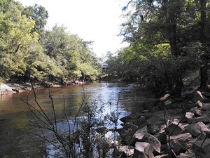 Paddle upstream on the Little River and float back down:
the WWALS June Outing.
Paddle upstream on the Little River and float back down:
the WWALS June Outing.
When: Please arrive by 8:30 AM so everyone can be ready to put in by 9AM.
Where: GA 133 bridge at the border of Brooks County and Lowndes County, Georgia. If we go far enough up, Continue reading
June WWALS Board meeting by teleconference 7:30 PM 11 June 2014
 Board meetings are open to the public.
Draft Agenda (revised to add GWC, June outing, signs, IRS status, and Waycross Adopt-A-Stream, and to fix time of day.
WWALS Board of Directors
7:30 PM Wednesday June 11 2014
by teleconference
Dial-in Number: (712) 432-1212
Meeting ID: 974-054-025
Board members are listed in www.wwals.net: Continue reading
IRS confirmed 501(c)(3) status for WWALS
Treasurer Gretchen Quarterman reports she received a letter from the IRS yesterday (PDF, image):
Dear Applicant,
We are pleased to inform you that upon review of your application for tax exempt status we have determined that you are exempt from Federal income tax under section 501(c)(3) of the Internal Revenue Code. Contributions to you are tax deductible bequests, devises, transfers or gifts under section 2055, 2106 or 2522 of the Code.

This nonprofit educational public charity status for WWALS is effective as of our date of incorporation, June 8th, 2012. So all contributions to WWALS back to that date are officially tax-deductible.
-jsq
Alapaha Greenway Trail?
A Greenway Trail is an onland version of the sort of Blueways or Water Trails WWALS is working on. WWALS board member Chris Graham got a very nice spread in one of the Lakeland newspapers today about Greenways, speaking for himself. -jsq
Lanier County Advocate, 4 June 2014, Page 12, Local nature enthusiast hoping to bring Greenway Trail to Lakeland,
Naylor native Christopher Graham has spent the majority of his life exploring the great outdoors every chance he gets.
Currently, Graham serves on the board of the Water Shed group to help ensure local rivers are clean and safe for citizens to enjoy. But what Graham has been striving for is to bring a Greenway Trail to the local area.
What are Greenway Trails? Continue reading
Regional Water Council Meeting Wednesday AM in Valdosta
Meeting notice: -jsq
NOTICE:
SUWANNEE-SATILLA
REGIONAL WATER PLANNING COUNCIL MEETING
FOR
REGIONAL ASSESSMENT OF IMPLEMENTATION STATUS
Announcement Date: May 6, 2014
TO ALL INTERESTED PERSONS AND PARTIES:
The Suwannee-Satilla Regional Water Planning Council is holding its next meeting
at the following date, time, and location:
Wednesday, May 21, 2014
Registration: 9:30 A.M. – 10:00 A.M.
Meeting: 10:00 A.M. – 1:00 P.M.
Valdosta City Hall Annex
Multipurpose Room
300 N. Lee Street
Valdosta, GA
For additional information about the Suwannee-Satilla Regional Water Planning
Council please contact:
Cliff Lewis, Assistant Branch Chief – EPD Watershed Protection Branch
229-391-2400 or Cliff.Lewis@dnr.state.ga.us
Study before Levee –Tim Carroll
Comment on facebook 10 May 2014 and he told me the same by telephone.
It is clear a full watershed wide study must be completed before any decisions can be made.
As established in this first study—The City of Valdosta is the recipient-not the origin- of the flood waters. While it confirms what we already knew, my job is to try and keep the ball rolling forward. Engage congressional leaders, secure funding and find long term, sustainable solutions that benefit all communities within the watershed basin. A levee by itself is not the answer.
–Tim Carroll
This was a comment on Videos: Flooding study by Army Corps of Engineers @ VCC 2014-05-06, which was about the initial study that was confined to Valdosta, and in which the Corps proposed a levee at the mouth of Sugar Creek, above the Withlacoochee River. To their credit, the Corps were clear that they also want a long-term watershed-wide study (they want to do the entire Suwannee River drainage area), and one of the main conclusions of the initial study was:
This report established that there could be Federal interest in pursuing future flood management risk studies undre other USACE authorities.
-jsq
May WWALS Board Meeting at the Gaskins Forest Education Center
Board meetings are open to the public.
Board members are listed in
www.wwals.net.
Draft Agenda
WWALS Board of Directors
7:00 PM Wednesday May 14 2014
at the Gaskins Forest Education Center,
3359 Moore Sawmill Rd,
Alapaha, GA 31622
Gate opens at 6PM.
- Call to Order, Welcome and Introductions
Speaker: Heather Brasell may say a few words about the Gaskins Forest Education Center.
- Agenda Review: Additions and Changes
- Review and Approval of Minutes
- Past Meetings and Events Continue reading
Flooding charts: Withlacoochee and Little Rivers
Update 2025-09-21: Graphs from water.noaa.gov.
 Related to the
Withlacoochee and Little River Water Trail
and the
double USACE flooding study presentation tonight in Valdosta,
here are river level charts
upstream and down on the Little River,
Okapilco Creek, and the Withlacoochee River
related to a new USGS flood-tracking chart.
In the example charts on the right, you can see the Little River peaked days ago at Tifton and yesterday at Hahira.
Related to the
Withlacoochee and Little River Water Trail
and the
double USACE flooding study presentation tonight in Valdosta,
here are river level charts
upstream and down on the Little River,
Okapilco Creek, and the Withlacoochee River
related to a new USGS flood-tracking chart.
In the example charts on the right, you can see the Little River peaked days ago at Tifton and yesterday at Hahira.
The Withlacoochee River peaked yesterday at US 41. while downstream it’s going up at US 84, and barely starting up at Pinetta (click on the above chart example for the rest). Right now you can see all that in the charts below. If this works, you’ll see something different later, because you’ll see current charts whenever you refresh this page.
Tifton Gauge, Little River at Upper Ty Ty Road, near Tifton, GA, Tift County, GA (02317797)
Highest safe 3.9 feet, 271 NAVD. Lowest boatable 0.1 feet, 267.2 NAVD.
Adel Gauge, Little River near Adel, GA, Cook County, GA (02318000)
Highest safe 7.9 feet, 181 NAVD. Lowest boatable 2.2 feet, 175.3 NAVD.
Hahira Gauge, Little River at GA 122, near Hahira, GA, Lowndes County, GA (02318380)
Highest safe 11 feet, 144 NAVD. Lowest boatable 4.25 feet, 137 NAVD.
Skipper Bridge Gauge, Withlacoochee River at Skipper Bridge Road, near Bemiss, GA, Lowndes County, GA (023177483)
Highest safe 10.7 feet, 131 NAVD. Lowest boatable 2.3 feet, 122.6 NAVD.
Valdosta Gauge, Withlacoochee River at US 41 near Valdosta, GA, Lowndes County, GA (02317755)
Highest safe 12.7 feet, 123′ NAVD. Lowest boatable 5.7 feet, 116′ NAVD.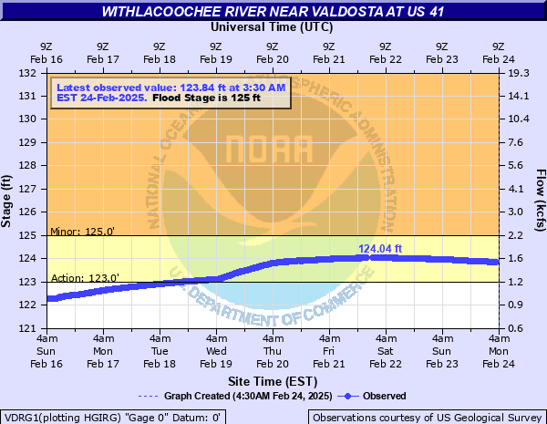
Okapilco Creek Gauge, Okapilco Creek at GA 333, near Quitman, GA, Brooks County, GA (02318700)

Quitman Gauge, Withlacoochee River at US 84, near Quitman, GA, Brooks County, GA (02318500)
Highest safe 10.5 feet, 94 NAVD. Lowest boatable 2.0 feet, 85.5 NAVD.
Pinetta Gauge, Withlacoochee River near Pinetta, FL., Madison County, FL (02319000)
Highest safe 12.5 feet, 59 NAVD. Lowest boatable 6.0 feet, 52.5 NAVD.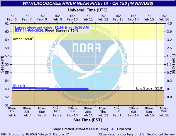
Madison Gauge, Withlacoochee River near Madison, FL , Madison County, FL (02319300)
Highest safe 10.0 feet, 50 NAVD. Lowest boatable 0.1 feet, 40.1 NAVD.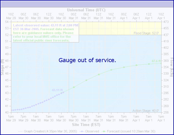
Lee Gauge, Withlacoochee River near Lee, FL, Madison County, FL (02319394)
Highest safe 44.0 feet, 44 NAVD. Lowest boatable 29.5 feet, 29.5 NAVD.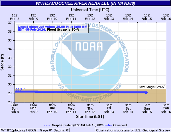
The watersheds
See also interactive map.

See also
- South Atlantic Water Science Center – Georgia.
- USGS Streamflow for Georgia and Florida.
- SRWMD water levels.
- NOAA USGS National Water Prediction Service
- USGS Flood Inundation Mapper (FIM) for the Withlacoochee River from Skipper Bridge to GA 133.
Old updates
Update 2016-05-31: See sea level gage reports.
Update 2016-04-27: graphs from water.weather.gov and some WRWT Safe Water Levels.
Update 2014-11-04: Simplified gage formatting.
Update 2014-11-03: That works, and see also Alapaha River water levels.
-jsq, John S. Quarterman, Suwannee RIVERKEEPER®
You can help with clean, swimmable, fishable, drinkable, water in the 10,000-square-mile Suwannee River Basin in Florida and Georgia by becoming a WWALS member today!
https://wwals.net/donations/
Grants to clean up two creeks in south Georgia
 Funds are available for farmers, ranchers, and forest owners
to help clean up two creeks in WWALS watersheds:
Deep Creek in Turner County, a tributary of the Alapaha River,
and Piscola Creek in Thomas and Brooks Counties, a tributary
of the Withlacoochee River.
The deadline for applications is May 16th.
Funds are available for farmers, ranchers, and forest owners
to help clean up two creeks in WWALS watersheds:
Deep Creek in Turner County, a tributary of the Alapaha River,
and Piscola Creek in Thomas and Brooks Counties, a tributary
of the Withlacoochee River.
The deadline for applications is May 16th.
WCTV via AP 5 April 2104, Georgia to Clean Up Waterways, Continue reading