Tag Archives: U.S. Army Corps of Engineers

EPA Clean Water Rule finalized

I still see EPA’s new Clean Water Rule as a good thing, since it protects drinking water, paddling, and fishing, while opponents remain quite vague about what might be wrong with it.

After last year’s comment period, U.S. EPA has posted a prepublication version of its final Clean Water Rule.

Katie Shepherd, L.A. Times, 27 May 2015, Under new EPA rule, Clean Water Act protections will cover all active tributaries, Continue reading

Widening US 84 from Homerville to Waycross

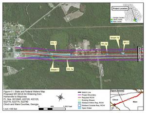
300x232 Figure 4.1: State and Federal Waters Map, in US 84 four-laning from Homerville to Waycross, by John S. Quarterman, for WWALS.net, 28 April 2015 GDOT and the Army Corps want to widen U.S. 84 from Homerville to Waycross. Since it appears that US 84 is already four lane from Thomasville through Quitman and Valdosta to Homerville, and from Waycross onwards northeast, this would be the remaining gap. The public notice says little or nothing about why this road work might be needed.

U.S. Army Corps of Engineers, Public Notice, 28 April 2015, SAS-2014-00862 (SP-WMR), Widening and Reconstruction of U.S. Highway 84, with PDF. Since that notice says it expires in a month, there’s also a copy of the PDF on the WWALS website, including this location information: Continue reading

Valdosta spilled into Alapaha as well as Withlacoochee watersheds in February

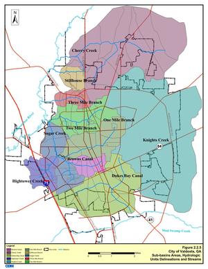
Spilling sewage into the Withlacoochee River apparently wasn’t enough 300x388 Figure 2.2.5. Sub-basins Areas, in Section 2 Methodology, by City of Valdosta, for WWALS.net, 14 January 2011 for Valdosta: in February it also spilled three times into the Alapaha River watershed. At least once this was due to rains directly on Valdosta, for which the levee proposed by the Army Corps of Engineers on Sugar Creek at the Withlacoochee River wouldn’t help. It’s time for Valdosta to move along with fixing its wastewater problems. More transparency from Valdosta would also help. And I, for one, would like to see that promised Corps flooding study of the entire Suwannee River Basin.

In three different reports in February, Valdosta mentioned sewage overflows into either Knights Creek or Dukes Bay Canal, without mentioning that those flow into Mud Swamp Creek, which joins with Grand Bay Creek to form the Alapahoochee River, which joins the Alapaha River, which flows into the Suwannee River. The Florida Department of Health apparently didn’t know that, since it didn’t mention the Alapaha River in its advisories for counties downstream. But Valdosta should know, according to its own SWMP Update Phase 1 Final Report, Section 2 Methodology, 2011-01-14, that about half of Valdosta is drained by Knights Creek and Dukes Bay Canal: Continue reading

Withlacoochee River sewage spills, Suwannee River Basin flooding study, and Valdosta’s funded plan to fix its problem

Someone referred to the mid-February Old Statenville Road spill in asking:

What’s happening in your watershed? This is the most recent of several sewage overflow issues I’ve been reading about.

Brief answer: this flooding issue is one of many reasons WWALS Watershed Coalition was formed; we’ve been on it since then; the City of Valdosta is being fixed the immediate problem; however there’s a much bigger problem throughout the entire Suwannee River Basin that the Army Corps of Engineers is studying.

Long answer: This has been going on for years, especially starting with the 700-year flood in 2009, which overflowed the City of Valdosta’s Withlacoochee Wastewater Treatment Plant (WWTP) and backed up sewage out of manholes, in addition to rivers and streams running over roads and bridges; see this USGS two-pager on that.

Larry Hanson, Valdosta City Manager, presented to Continue reading

WWALS Goals for 2014

A surprising number of the Board’s nine goals for 2014 have been accomplished, and some new ones have already been added. What goals should WWALS have for 2015?

Goals accomplished include becoming an IRS 501(c)(3) and raising money for and purchasing insurance. Some we’ve been doing right along: cleanups, including Rivers Alive. Some are so much the core of what WWALS does that we didn’t even list them as goals, but we’ve been doing them anyway: monthly outings and indoor events.

The later-added goal of the Alapaha River Water Trail is Continue reading

Proposed EPA Water rule

The U.S. Environmental Protection Agency proposes some new rules to clarify Clean Water Act protection. Some people and organizations have concerns about that, and the EPA has now responded to those concerns. Comment periods are still open for you to provide input directly to EPA about the proposed rule.

Here’s the EPA’s Waters of the United States Proposed Rule. EPA says clarification of the Clean Water Act was requested by a broad range of state, tribal, and local government agencies and elected officials and NGOs, ranging from AASHTO to the National Association of State Foresters. One of the two examples EPA cites of state enforcement problems is on the Flint River in Georgia:

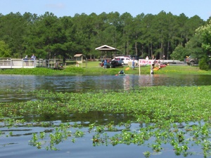
Recreation in Lake Blackshear, Georgia

Continue reading

Study before Levee –Tim Carroll

Comment on facebook 10 May 2014 and he told me the same by telephone.

It is clear a full watershed wide study must be completed before any decisions can be made. As established in this first study—The City of Valdosta is the recipient-not the origin- of the flood waters. While it confirms what we already knew, my job is to try and keep the ball rolling forward. Engage congressional leaders, secure funding and find long term, sustainable solutions that benefit all communities within the watershed basin. A levee by itself is not the answer.
–Tim Carroll

This was a comment on Videos: Flooding study by Army Corps of Engineers @ VCC 2014-05-06, which was about the initial study that was confined to Valdosta, and in which the Corps proposed a levee at the mouth of Sugar Creek, above the Withlacoochee River. To their credit, the Corps were clear that they also want a long-term watershed-wide study (they want to do the entire Suwannee River drainage area), and one of the main conclusions of the initial study was:

This report established that there could be Federal interest in pursuing future flood management risk studies undre other USACE authorities.

-jsq

May WWALS Board Meeting at the Gaskins Forest Education Center

Board meetings are open to the public. Board members are listed in www.wwals.net.

Draft Agenda
WWALS Board of Directors
7:00 PM Wednesday May 14 2014
at the Gaskins Forest Education Center,
3359 Moore Sawmill Rd,
Alapaha, GA 31622
Gate opens at 6PM.
  1. Call to Order, Welcome and Introductions
  2. Speaker: Heather Brasell may say a few words about the Gaskins Forest Education Center.
  3. Agenda Review: Additions and Changes
  4. Review and Approval of Minutes
    1. 16 April 2014 Board meeting minutes
  5. Past Meetings and Events Continue reading

Flooding charts: Withlacoochee and Little Rivers

Related to the Withlacoochee and Little River Water Trail and the double USACE flooding study presentation tonight in Valdosta, here are river level charts upstream and down on the Little River, Okapilco Creek, and the Withlacoochee River related to a new USGS flood-tracking chart. In the example charts on the right, you can see the Little River peaked days ago at Tifton and yesterday at Hahira.

The Withlacoochee River peaked yesterday at US 41. while downstream it’s going up at US 84, and barely starting up at Pinetta (click on the above chart example for the rest). Right now you can see all that in the charts below. If this works, you’ll see something different later, because you’ll see current charts whenever you refresh this page.

Update 2016-05-31: See sea level gage reports.

Update 2016-04-27: graphs from water.weather.gov and some WRWT Safe Water Levels.

Update 2014-11-04: Simplified gage formatting.

Update 2014-11-03: That works, and see also Alapaha River water levels.


Tifton Gauge, Little River at Upper Ty Ty Road, near Tifton, GA, Tift County, GA (02317797)

Highest safe 3.9 feet, 271 NAVD. Lowest boatable 0.1 feet, 267.2 NAVD.

Adel Gauge, Little River near Adel, GA, Cook County, GA (02318000)

Highest safe 7.9 feet, 181 NAVD. Lowest boatable 2.2 feet, 175.3 NAVD.

Hahira Gauge, Little River at GA 122, near Hahira, GA, Lowndes County, GA (02318380)

Highest safe 11 feet, 144 NAVD. Lowest boatable 4.25 feet, 137 NAVD.

Skipper Bridge Gauge, Withlacoochee River at Skipper Bridge Road, near Bemiss, GA, Lowndes County, GA (023177483)

Highest safe 10.7 feet, 131 NAVD. Lowest boatable 2.3 feet, 122.6 NAVD.

Valdosta Gauge, Withlacoochee River at US 41 near Valdosta, GA, Lowndes County, GA (02317755)

Highest safe 12.7 feet, 123′ NAVD. Lowest boatable 5.7 feet, 116′ NAVD.

Okapilco Creek Gauge, Okapilco Creek at GA 333, near Quitman, GA, Brooks County, GA (02318700)


Quitman Gauge, Withlacoochee River at US 84, near Quitman, GA, Brooks County, GA (02318500)

Highest safe 10.5 feet, 94 NAVD. Lowest boatable 2.0 feet, 85.5 NAVD.

Pinetta Gauge, Withlacoochee River near Pinetta, FL., Madison County, FL (02319000)

Highest safe 12.5 feet, 59 NAVD. Lowest boatable 6.0 feet, 52.5 NAVD.

Madison Gauge, Withlacoochee River near Madison, FL , Madison County, FL (02319300)

Highest safe 10.0 feet, 50 NAVD. Lowest boatable 0.1 feet, 40.1 NAVD.

Lee Gauge, Withlacoochee River near Lee, FL, Madison County, FL (02319394)

Highest safe 44.0 feet, 44 NAVD. Lowest boatable 29.5 feet, 29.5 NAVD.

315x535 WRWT, in Withlacoochee River Water Trail gauges, by John S. Quarterman, for WWALS.net, 8 June 2015

 -jsq, John S. Quarterman, Suwannee RIVERKEEPER®

You can join this fun and work by becoming a WWALS member today!

Flooding study presentations by Army Corps in Valdosta 6 May 2014

Received today. -jsq

Good afternoon Mr. Quarterman,

As requested, the date for the U.S. Army Corps of Engineers (USACE) presentation will be on May 6th to Mayor/Council at the work session which begins at 5:30 pm. The City will also have a meeting with the residents and businesses in the USACE project / study area that same night at 6:30 pm at the City Hall Annex – Multipurpose Room.

Continue reading