Tag Archives: water

Flooding charts: Withlacoochee and Little Rivers

Related to the Withlacoochee and Little River Water Trail and the double USACE flooding study presentation tonight in Valdosta, here are river level charts upstream and down on the Little River, Okapilco Creek, and the Withlacoochee River related to a new USGS flood-tracking chart. In the example charts on the right, you can see the Little River peaked days ago at Tifton and yesterday at Hahira.

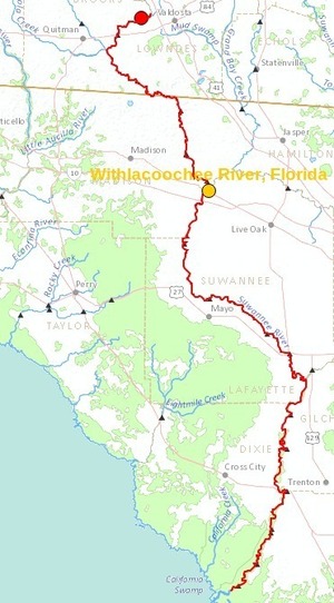
The Withlacoochee River peaked yesterday at US 41. while downstream it’s going up at US 84, and barely starting up at Pinetta (click on the above chart example for the rest). Right now you can see all that in the charts below. If this works, you’ll see something different later, because you’ll see current charts whenever you refresh this page.

Update 2016-05-31: See sea level gage reports.

Update 2016-04-27: graphs from water.weather.gov and some WRWT Safe Water Levels.

Update 2014-11-04: Simplified gage formatting.

Update 2014-11-03: That works, and see also Alapaha River water levels.


Tifton Gauge, Little River at Upper Ty Ty Road, near Tifton, GA, Tift County, GA (02317797)

Highest safe 3.9 feet, 271 NAVD. Lowest boatable 0.1 feet, 267.2 NAVD.

Adel Gauge, Little River near Adel, GA, Cook County, GA (02318000)

Highest safe 7.9 feet, 181 NAVD. Lowest boatable 2.2 feet, 175.3 NAVD.

Hahira Gauge, Little River at GA 122, near Hahira, GA, Lowndes County, GA (02318380)

Highest safe 11 feet, 144 NAVD. Lowest boatable 4.25 feet, 137 NAVD.

Skipper Bridge Gauge, Withlacoochee River at Skipper Bridge Road, near Bemiss, GA, Lowndes County, GA (023177483)

Highest safe 10.7 feet, 131 NAVD. Lowest boatable 2.3 feet, 122.6 NAVD.

Valdosta Gauge, Withlacoochee River at US 41 near Valdosta, GA, Lowndes County, GA (02317755)

Highest safe 12.7 feet, 123′ NAVD. Lowest boatable 5.7 feet, 116′ NAVD.

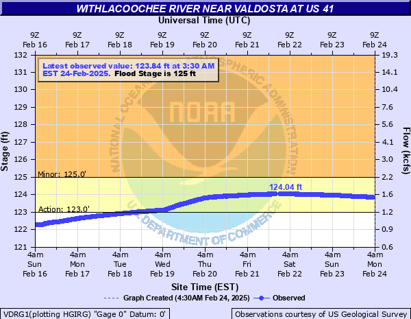
Okapilco Creek Gauge, Okapilco Creek at GA 333, near Quitman, GA, Brooks County, GA (02318700)


Quitman Gauge, Withlacoochee River at US 84, near Quitman, GA, Brooks County, GA (02318500)

Highest safe 10.5 feet, 94 NAVD. Lowest boatable 2.0 feet, 85.5 NAVD.

Pinetta Gauge, Withlacoochee River near Pinetta, FL., Madison County, FL (02319000)

Highest safe 12.5 feet, 59 NAVD. Lowest boatable 6.0 feet, 52.5 NAVD.

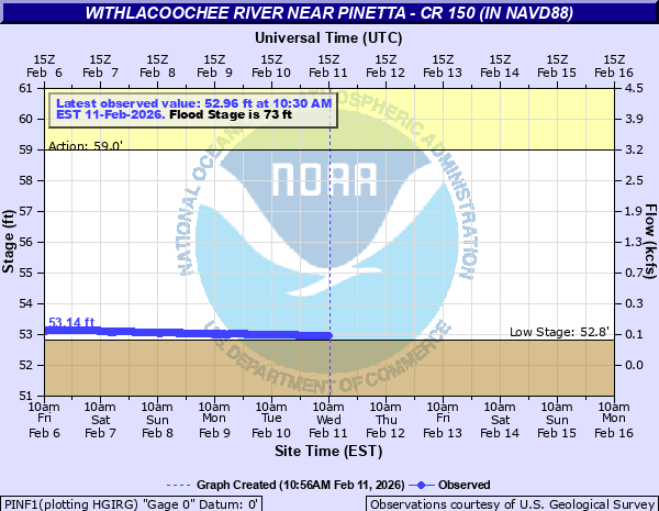
Madison Gauge, Withlacoochee River near Madison, FL , Madison County, FL (02319300)

Highest safe 10.0 feet, 50 NAVD. Lowest boatable 0.1 feet, 40.1 NAVD.

Lee Gauge, Withlacoochee River near Lee, FL, Madison County, FL (02319394)

Highest safe 44.0 feet, 44 NAVD. Lowest boatable 29.5 feet, 29.5 NAVD.
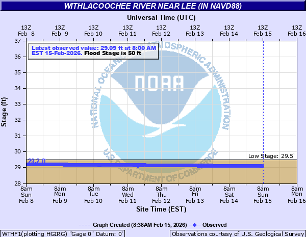
315x535 WRWT, in Withlacoochee River Water Trail gauges, by John S. Quarterman, for WWALS.net, 8 June 2015

 -jsq, John S. Quarterman, Suwannee RIVERKEEPER®

You can join this fun and work by becoming a WWALS member today!

Billboard for Withlacoochee Paddle Event 2014-04-19

This billboard has already been spotted on Bemiss Road in Valdosta.

Please join us at 7:30 AM Saturday 19 April 2014 on the Withlacoochee River between Valdosta and Quitman, to put in at Old Quitman Road on the Brooks County side (just south of US 84) and paddle past where the proposed Sabal Trail methane pipeline would cross the Withlacoochee River, Continue reading

Cancelled! Paddle Against the Pipeline on the Withlacoochee River: 19 April 2014

Update 9PM 16 April 2014: Cancelled due to flood-stage water levels in the Withlacoochee River, with more rain expected Friday. To be rescheduled.

7:30 AM Saturday 19 April 2014 on the Withlacoochee River between Valdosta and Quitman, put in at Old Quitman Road on the Brooks County side (just south of US 84): Paddle past where the proposed Sabal Trail methane pipeline would cross the Withlacoochee River, digging into our fragile karst limestone, above our drinking-water Floridan Aquifer. This is a joint event of Continue reading

Valdosta famous into Florida again for wastewater spill

As two of the Suwannee Democrat’s commentors ask:

Why does Valdosta keep having these spills?
Hasn’t this happened like 3 times now?

Why yes, yes it has. For example, Valdosta became famous for this all the way to the Gulf 3 March 2013, and there were two more spills in 2013 to add to the big one in 2009. However, the City of Valdosta has promised to use SPLOST and other funding to fix it within a few years. As AP reported Friday:

The city of Valdosta says it is making improvements to the Withlacoochee Water Pollution Control Plant to prevent future problems.

Staff, Suwannee Democrat, 28 February 2014, Florida Department of Health advises of possible wastewater contamination: Wastewater overflow from Valdosta, Ga. may impact Withlacoochee and Suwannee Rivers

Live Oak — The Florida Department of Health (DOH) today issued an advisory to residents in counties surrounding the Withlacoochee and Suwannee rivers. The City of Valdosta has reported a spill, made up of a combination of storm water and partially treated sewage, that has overflowed into the Withlacoochee River. The Withlacoochee flows south and connects with the Suwannee River.

Until further information Continue reading

Pipeline alternate route still in WWALS watersheds, plus Tifton and Valdosta

The Hillabee alternative route runs right down the middle of the WWALS watersheds, through Worth County, Turner County, Tift County, Colquitt County, Cook County, and Lowndes County in Georgia, and Hamilton County, Madison County, and Suwannee County in Florida. This puts it not only still in the Withlacoochee River watershed, but also in the Little River and Alapaha River watersheds. This route by the pipeline company Sabal Trail Transmission (owned and managed by Spectra Energy) avoids Albany but apparently goes through Tifton and Valdosta and still through Lowndes County before entering Florida in Hamilton County much like Spectra’s preferred route.

Hillabee (Valdosta and Tift County) Route Alternative, Georgia

This alternate route is the rest of the Option B that was first proposed to Lowndes County residents back in June: Continue reading

Ask Georgia Power to conserve our water –WWALS to GA PSC

Approved 12 June 2013 by unanimous vote of the WWALS board, Dave has mailed a signed copy to the Georgia Public Service Commission, and I will go read it to the PSC Tuesday morning at 10 AM 18 June 2013, at their hearing about

Docket 36498, Georgia Power Company’s 2013 Integrated Resource Plan and Application for Decertification of Various Units
and
Docket 36499, Application for the Certification of Amended Demand Side Management Plan

Y’all come! -jsq

From: WWALS Watershed Coalition, Inc.
3338 Country Club Road #L336
Valdosta, GA 31605
12 June 2013

To: Georgia
Public Service Commission

244 Washington Street, SW
Atlanta GA, 30334-9052

Dear Public Service Commissioners and Staff,

The recent rains have swollen our blackwater rivers, Withlacoochee, Willacoochee, Alapaha, and Little, under our longleaf pines and Spanish-moss-covered oaks, and filled up the tea-colored tannin waters in our frog-singing pocosin cypress swamps here in central South Georgia. But that was only a dent in our protracted drought that ranges from mild to extreme, with projections not much better.

We do not need more traditional big baseload power plants gulping down our river or aquifer water when solar and wind power use far less, and those renewables are now at grid parity with coal, natural gas, and nuclear.

Power plants are thirsty, as the Union of Concerned Scientists pointed out in a 2011 report, “Freshwater Use by U.S. Power Plants: Electricity’s Thirst for a Precious Resource”.

Much of the water used to cool power plants evaporates, and is Continue reading

Arsenic, Outings, and Flooding: WWALS Watershed Coalition @ VLCIA 2013-04-16

Water issues strongly affect economic development, so I talked about the new WWALS Watershed Coalition at the 16 April 2013 Board Meeting of the Valdosta-Lowndes County Industrial Authority.

The VDT declined to speak, so I did. After apologizing for no okra today, I commended the Authority for talking about the missing agenda items and for mentioning due diligence and flood control.

Mostly I talked about the new WWALS Watershed Coalition, www.wwals.net, incorporated in June 2012, which is about watershed issues such as flooding, water quality, and invasive species related to the Withlacoochee, Willacoochee, Alapaha, and Little River System. I mentioned arsenic in some local well water, which the Department of Health has finally said should be tested, three years after Janet McMahan discovered it was a problem. I invited VLCIA board and staff to two upcoming WWALS events:

WWALS board meetings are every second Wednesday of the month, usually at the IHOP in Adel because it’s centrally located. WWALS is communicating with Valdosta and various organizations about flooding and other watershed-wide issues, which in my opinion have to do with things like too much clearcutting without consideration for where the water goes, too much development without consideration for what the impervious surface would do, (to my surprise, the Executive Director and several board members nodded along with that) so it was good to hear them mention flood containment.

Here’s the video:


Arsenic, Outings, and Flooding: WWALS Watershed Coalition
Regular Meeting, Valdosta-Lowndes County Industrial Authority (VLCIA),
Norman Bennett, Tom Call, Roy Copeland, Chairman, Mary Gooding, Jerry Jennett, Andrea Schruijer, Executive Director, J. Stephen Gupton, Attorney, Tom Davis, CPA, Allan Ricketts, Project Manager,S. Meghan Duke, Public Relations & Marketing Manager, Lu Williams, Operations Manager,
Video by John S. Quarterman for Lowndes Area Knowledge Exchange (LAKE), Valdosta, Lowndes County, Georgia, 16 April 2013.

-jsq

Test wells for arsenic –South Health District

Janet McMahan and Erin Brocovich More than three years after Janet McMahan found toxic levels of arsenic in her well water in Ben Hill County, more than half a year after she told us about it at a WWALS water quality testing training, and four months after Erin Brokovich agreed it was a problem, the Georgia Departnment of Health finally has sounded the alarm. They still left out part of the story, though.

The Valdosta Daily Times carried the story in its paper Saturday edition, but apparenlty never put it online. WTXL’s story Friday by Jade Bulecza, UPDATE: South Georgians urged to test private wells due to arsenic risk, quoted Dr. Grow, head of our local eleven-county South Health District:

Continue reading

Lead, arsenic, and uranium in water causing cancer –Janet McMahan

Uranium? Yes, really: it comes out of granite rocks up deep water wells in the Georgia Piedmont. The other metals arsenic come from human energy, industrial, and agricultural activities, ranging from fenceposts to Plant Scherer, dirtiest coal plant in the country, emitting mercury, some of which ends up in the Alapaha River. Here’s video of Janet McMahan speaking about this:


Janet McMahan spoke to the group after the
Adopt-A-Stream water quality testing training
taught by Angela Bray and Richard Batten.
Video by Gretchen Quarterman for WWALS Watershed Coalition (WWALS),
Valdosta, Lowndes County, Georgia, 5 August 2012

Janet McMahan adds:

Continue reading

Oil drilling in our aquifer?

There’s a bill in the Florida House to drill for oil in a state park in the same aquifer we drink out of.

A group is organizing through facebook and reddit and elsewhere to oppose this bill:

Save Blackwater River State Forest

An alliance of citizens committed to protecting the beautiful Blackwater River State Forest from proposed House Bill 431, that would allow oil and mining in the forest.
Continue reading