
Now is not a good time to stay overnight in the Okefenokee Swamp, or to travel at night between Fargo and Moniac, because of smoke.
Lightning started the West Mims fire Thursday, apparently west of Moniac, Georgia in Baker County, Florida. That was in the St Marys River watershed, but the fire has since expanded west and north into the upper Suwannee River watershed and Ware County, Georgia. According to today’s update from InciWeb, the Incident Information System, the fire now involves 13,000 acres and is only 3% contained. Even with 110 firefighters and a variety of equipment, the estimated containment date is two months from now: “Thursday June 15th, 2017 approx. 12:00 AM”. It is a southern fire forest, after all.
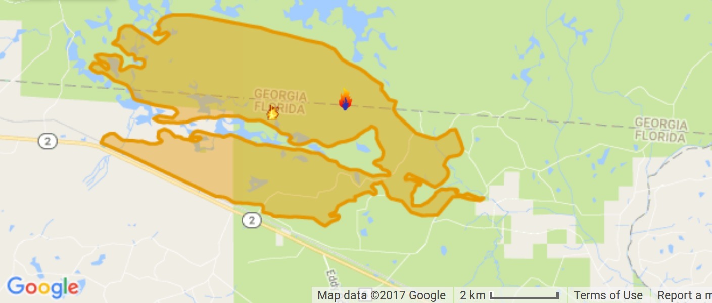
Map from InciWeb 2017-04-15.
Approximate Location 30.574 latitude, -82.323 longitude.
It’s probably best not to go there at night, since InciWeb says:
ROAD CLOSURE: FL2/GA94 from the agricultural check station at the GA/FL line to U.S. 441 in Fargo is now closed due to low visibility from smoke. It will be closed nightly from 10:00 p.m. to 10:00 a.m.
The Wilderness Canoe Trail overnight stops are being closed to overnight use beginning on Monday, April 17. Day use canoeists and guided boat tours will still be able to access the trails at the current time.
A burn ban is in place within the Okefenokee National Wildlife Refuge, including Stephen C. Foster State Park. The ban includes fires at designated campsites and charcoal grills.

Detail from WWALS Watersheds google map
showing the Upper Suwannee River watershed in the red on the left,
and the St Marys River watershed on the right.
How they’re fighting the fire is explained by Terry Dickson, jacksonville.com, 12 April 2017, West Mims Fire at 6,752 acres, Florida 2/Georgia 94 closed until further notice
One-hundred-ten personnel are battling the fire with no containment and it is burning in the Okefenokee National Wildlife Refuge in Florida and Georgia and in Florida alone in the Osceola National Forest and the John M. Bethea State Forest, a fire public information officer said in a prepared statement.
Crews have conducted “strategic firing operations” below the southern perimeter of the fire to burn out potential fuels to prevent it from moving further south. Most burnouts have been along the Georgia Southern and Florida Railway right-of-way parallel to Florida 2.
The fire is burning in an area with timber and undergrowth and also areas of thick, low-growing vegetation called shrub/scrub. The fire has also made some short crown runs, in which it has burned into the tree tops, according to a fire information website.
Because of smoke on the roadway and fire operations, Florida 2/Georgia 94 is closed from the Florida agriculture check station at the state line to the east to U.S. 441 at Fargo, Ga., to the west.
A Georgia Forest Commission management team will direct fire operations and the Florida Forest Service, U.S. Fish and Wildlife Service, U.S. Forest Service and the Greater Okefenokee Association of Landowners, or GOAL, are cooperating in managing the fire. GOAL is composed mostly of timber companies that own land bordering the perimeter of the refuge.
All public entrances remain open, and no private structures were in danger as of the last update late Tuesday.

NASA, 12 April 2017,
NASA’s Terra Satellite Spots West Mims Fire,
“Plumes of smoke were spotted by NASA’s Terra satellite as they streamed from the West Mims Fire near the Florida and Georgia border.”
Terry Dickson, Jacksonville.com, 14 April 2017, West Mims Fire nears 9,000 acres burned, expected to move north,
Because of the wind direction, the fire is expected to begin moving north and teams are using bulldozers and other heavy equipment to reinforce fire lines on the northwest side to keep it inside the refuge boundaries and off private land.
It appears that the fire is being kept inside the one-mile buffer of longleaf pine that has already had regular prescribed burns, organized by the Okefenokee-Osceola Local Implementation Team; see WWALS blog post of 2 August 2016 and the map below.
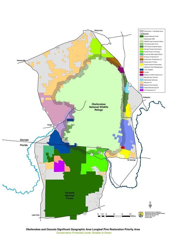
The grey area is the buffer zone, which runs along FL 2 right where the south edge of the West Mims Fire is.
We will keep observing and reporting on the West Mims Fire. Firefighting is not our specialty, but we can at least help you know what is going on.
-jsq, John S. Quarterman, Suwannee RIVERKEEPER®
You can join this fun and work by becoming a WWALS member today!
Here is the latest posted InciWeb update so far, West Mims Fire Update – April 15, 2017,
Incident: West Mims Fire Wildfire
Released: 4 hrs. ago
FAST FACTS: The West Mims Fire is currently 13,000 acres and 3% contained. 144 personnel are assigned to this incident. Equipment resources include one helicopter, ten engines, five dozers, thirteen tractor plows and one hot shot crew.
Current fire situation: The fire was reported on April 6, 2017, approximately 2.5 miles northeast of Eddy Tower within the Okefenokee National Wildlife Refuge. The lightning-caused fire is currently burning within the Okefenokee National Wildlife Refuge, John M. Bethea State Forest, and Osceola National Forest. A Georgia Forestry Commission Type 2 Incident Management Team is managing the fire. Strategic firing operations have been successful in securing private property on the west side of the fire.
Planned action: Crews will be reinforcing containment lines and mopping up to contain the fire within the swamp edge break on the western side of the current fire perimeter. In cooperation with private landowners, preparation work with heavy equipment will continue on adjacent private lands to help improve firelines.
Fire weather: Conditions are warm and dry with easterly winds that will become gusty in the late afternoon. Fire activity may increase in the afternoon with increased winds out of the east/southeast as an afternoon sea breeze moves into the area. Fog will develop overnight with areas of dense fog and smoke after midnight.
Restrictions and closures: A burn ban is in place within the Okefenokee National Wildlife Refuge, including Stephen C. Foster State Park. The ban includes fires at designated campsites and charcoal grills. FL2/GA94 from the agricultural check station at the GA/FL line to U.S. 441 in Fargo will be closed nightly from 10:00 p.m. to 10:00 a.m. Temporary road closures may still occur based on operational needs or smoke impacts.
All public entrances to the Okefenokee National Wildlife Refuge are not currently impacted by the fire.
Short Link:
Pingback: Videos: More people, equipment, and smoke: West Mims Fire Okefenokee update 2017-04-16 | WWALS Watershed Coalition (Suwannee RIVERKEEPER®)
Pingback: All the way to GA 177: West Mims Fire 2017-04-30 | WWALS Watershed Coalition (Suwannee RIVERKEEPER®)