Tag Archives: riverkeeper

HPS II phosphate mine in Union and Bradford BOCC meetings

Steve Pieczenik called the Union County Commissioners brave, honest, respectful, efficient, and transparent public servants. Jim Tatum said they had foresight and had taken appropriate steps. Both complimented the many mine opponents who showed up and spoke their piece briefly and effectively. Here are a couple of reports from Union BOCC’s Monday workshop about the HPS II phosphate mine.

Aerial: From the New River across the HPS II mine site to Lake Butler
Photo: John S. Quarterman for WWALS on Southwings flight, 17 Sep. 2017, N from New River across mine site: l. New River P. r. Beasley; left center prison; top left Lake Butler, 09:55:21, 29.9550800, -82.3183000

The next one is coming up 5PM Tuesday, January 16, 2018, at which Union BOCC is scheduled to vote on extending its moratorium against phosphate mining, as well as reviewing their proposed Comprehensive Plan changes.

Meanwhile, across the New River, Bradford BOCC Continue reading

West Mims Fire completely out; update tomorrow 2017-08-07

The biggest fire in the country, that started April 6, 2017 in the Okefenokee National Wildlife Refuge, has been out for about a month now, put out by rains, after massive containment efforts by fire crews from many counties and states. Apparently Lowndes County, Georgia, sent some assistance, since they have a special presentation about that fire on their agenda for this week. Their agendas never say whether such presentations are in the Work Session, which was this morning at 8:30 AM (it wasn’t) or in the Regular Session, Tuesday evening at 5:30 PM (must be then). Gretchen Quarterman was there this morning, and says they said the presenter will be someone unnamed from Charlton County. Gretchen will video the presentation for Lowndes Area Knowledge Exchange (LAKE).

InciWeb West Mims Fire Incident Updated 7/11/2017
Map: InciWeb West Mims Fire Incident Updated 7/11/2017.

The fire within a week burned north into the Suwannee River watershed. A party of people we know, including Continue reading

More than 100,000 acres and Billy’s Island in West Mims Fire 2017-05-03

We got smoked here in western Lowndes County yesterday and this morning 60 miles from the West Mims fire as it went up to 107,846 acres in and around the Okefenokee NWR. Many of the fire-fighting numbers went down since last post: remember, the goal is not to put the fire out, rather to contain it. As I write, a big storm just went over here heading that way, so maybe mother nature will take a hand today.

The Valdosta Daily Times has been covering this fire right along, most recently by Terry Richards, VDT, 2 May 2017, Rain barely felt at massive swamp fire,

FARGO — A mild rainfall Monday had little to no impact on the West Mims Fire burning through the Okefenokee Swamp, according to a firefighter.

The blaze, which had burned more than 100,000 acres by Tuesday afternoon, received about a tenth of an inch of rain from a weak cold front that moved through South Georgia Monday.

“It didn’t help,” said Leland Bass, a firefighter and public information officer for the Georgia Forestry Commission.

Maybe they’ll get more rain in the swamp today. Continue reading

All the way to GA 177: West Mims Fire 2017-04-30

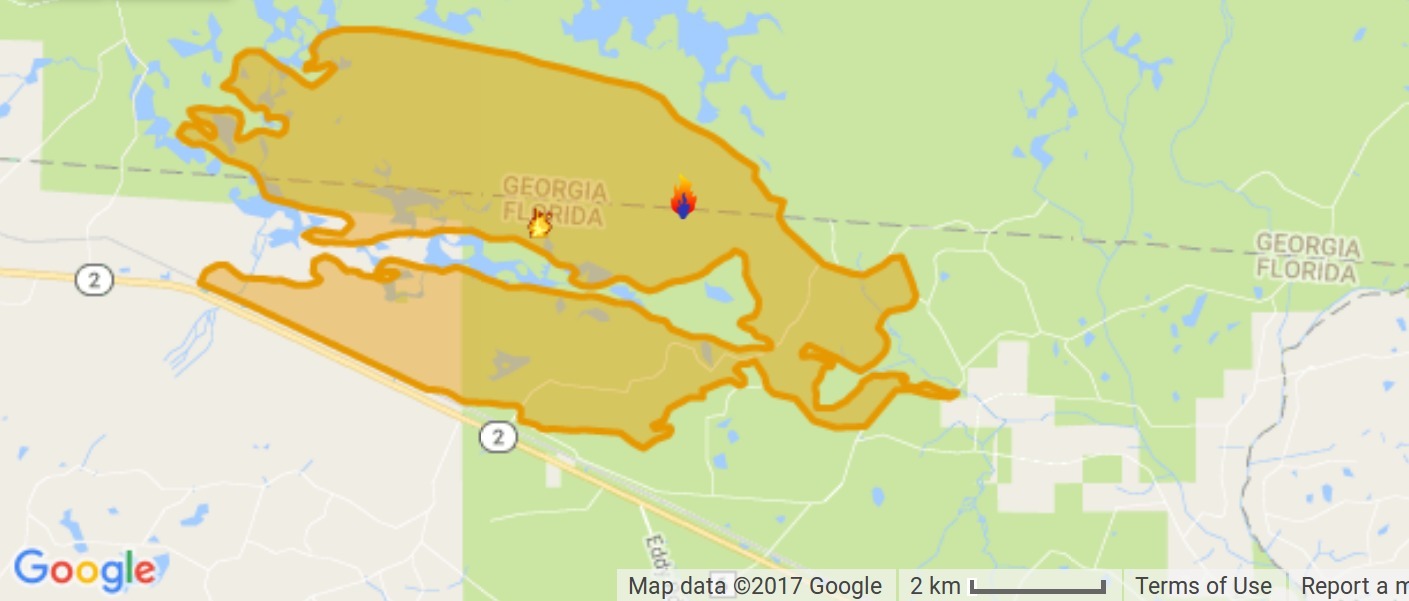
Well, this keeps escalating, now 96,248 acres, including some on Billy’s Island, opposed by 499 personnel, 6 helicopters, 57 wildland fire engines, 6 dozers, 37 tractor plows, and 2 interagency hot shot crews, according to InciWeb today. Some crews came from as far away as Denver, according to CBS Denver 26 April 2017, and the smoke has spread as far as North Carolina.

Fire Map, InciWeb, 2017-04-30
InciWeb map, West Mims Fire, 2017-04-30

Today’s InciWeb release does claim Continue reading

Videos: More people, equipment, and smoke: West Mims Fire Okefenokee update 2017-04-16

Naturally a party of people we know were paddling across the Okefenokee Swamp over the weekend, but far north of the fire, so they had no problems, getting out just before the overnight stops in the Okefenokee NWR close today. Apparently they could see skyglow of the West Mims Fire on the southern horizon at night. Meanwhile, smoke has been seen as far north as North Carolina and I can smell it in Lowndes County, 60 miles west of the fire.
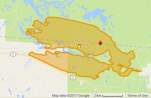
InciWeb map
Map by InciWeb, 16 April 2017.

Hannah Patrick, WWAYTV3, Wilmington, NC, 16 April 2017, Strong winds drive smoke from Georgia Wildfire into NC,

Multiple media outlets report that the National Weather Service in Raleigh said southwest winds pushed the smoke up Sunday from the southeast Georgia fire.

The Division of Environmental Quality air quality index number for the Triangle area of Raleigh, Durham and Chapel Hill hit the orange alert level Sunday. That means people who are sensitive to air quality should stay inside.

Officials believe the smoke is coming from the Georgia fire and not one in McDowell County, North Carolina, that the U.S. Forest Service said was about 85 percent contained as of Sunday.

InciWeb says the number of personnel has increased to 184, the number of engines to 17, and the number of tractor plows to 27; still 5 dozers and one hot shot crew. However, the acreage burned has increased to 18,551, with still only 3% contained, and the same estimated containment date two months out of Thursday June 15th, 2017 approx. 12:00 AM.

The fire still seems to be staying within the mile-wide buffer zone around the NWR established by the Okefenokee-Osceola Local Implementation Team.

Before we and our ancestors massively modified the environment of the U.S. southeastern coastal plains, back when there was a longleaf pine forest from southern Virginia to eastern Texas, lightning-lit fires would burn for many miles and many days.

 -jsq, John S. Quarterman, Suwannee RIVERKEEPER®

You can join this fun and work by becoming a WWALS member today!

West Mims Fire in Upper Suwannee River watershed in Okefenokee Swamp 2017-04-15

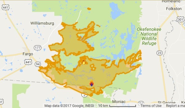
Now is not a good time to stay overnight in the Okefenokee Swamp, or to travel at night between Fargo and Moniac, because of smoke.

Lightning started the West Mims fire Thursday, apparently west of Moniac, Georgia in Baker County, Florida. That was in the St Marys River watershed, but the fire has since expanded west and north into the upper Suwannee River watershed and Ware County, Georgia. According to today’s update from InciWeb, the Incident Information System, the fire now involves 13,000 acres and is only 3% contained. Even with 110 firefighters and a variety of equipment, the estimated containment date is two months from now: “Thursday June 15th, 2017 approx. 12:00 AM”. It is a southern fire forest, after all.

Incident Map
Map from InciWeb 2017-04-15. Approximate Location 30.574 latitude, -82.323 longitude.

It’s probably best not to go there at night, since InciWeb says: Continue reading

WWALS Quarterly Board Meeting, IHOP, Adel, GA 2016-10-12

Includes planning for Valdosta wastewater and flood prevention meeting, and final review of application to Waterkeeper Alliance for Suwannee Riverkeeper.

Draft Agenda
WWALS Quarterly Board Meeting
7:30 PM Wednesday 12 October 2016
IHOP, 1200 W 4th St, Adel, GA 31620

All WWALS Board Members are expected to attend in person or by telephone. Continue reading