
 The Tifton newspaper carried the
press release Sunday April 26th
about the May 16th BIG Little River Paddle Race
at Reed Bingham State Park.
You can register online. Continue reading
The Tifton newspaper carried the
press release Sunday April 26th
about the May 16th BIG Little River Paddle Race
at Reed Bingham State Park.
You can register online. Continue reading
Category Archives: Outing
BIG Little River Paddle Race in Tifton Gazette
Third Annual BIG Little River Paddle Race PR 2015-05-16
FOR IMMEDIATE RELEASE:
 Charity paddle event to take place at Reed Bingham State Park
Valdosta, April 27th, 2015 — You are invited to paddle in the third annual BIG Little River Paddle Race on Saturday, May 16, 2015. Bring your canoe or kayak or Continue reading
Alapaha River Rise, Suwannee River, and Sabal Trail Pipeline, WWALS Outing 2015-08-15
Update 2015-07-27: Pictures and new pipeline information at this link.
 After the
Alapaha River sinks into the Florida Aquifer, some of it comes back up
at the
Alapaha Rise,
which actually flows into the Suwannee River, a bit upstream from the
Alapaha Confluence.
Come with WWALS to the Alapaha Rise, then down the Suwannee River
past the Confluences of both the Alapaha and the Withlacoochee Rivers,
seeing the proposed site of the Sabal Trail Pipeline on the way.
After the
Alapaha River sinks into the Florida Aquifer, some of it comes back up
at the
Alapaha Rise,
which actually flows into the Suwannee River, a bit upstream from the
Alapaha Confluence.
Come with WWALS to the Alapaha Rise, then down the Suwannee River
past the Confluences of both the Alapaha and the Withlacoochee Rivers,
seeing the proposed site of the Sabal Trail Pipeline on the way.
This is a pretty easy outing, but the Suwannee is deep,
so as always bring your personal flotation
device.
If you need a boat, let us know, and we can find you one.
| When: | 8AM Saturday, August 15th, 2015 |
|---|---|
| What: | 8 mile paddle from Gibson Park to Suwannee River State Park, with a side trip upstream first to the Alapaha Rise, then downstream past the Alapaha-Suwannee confluence, the proposed Sabal Trail Pipeline crossing, and ending at the Withlacoochee confluence, taking out at Suwannee River State Park. |
| Duration: | 4 hours, after a 30 minute shuttle. |
| Directions: | Florida Highway 6 in Hamilton County, Florida, west to CR751 South to park just before the river. |
| Responsible party: | Chris Mericle |
This event is FREE! All we ask is that you are a current member of WWALS Watershed Coalition. If not, it’s easy to join online today at /donations/. You do not have to be a member to come on this outing. If you like the experience, we recommend that you join to support the efforts of WWALS. Continue reading
Lanier Park to CSX RR track Hotchkiss Road, WWALS outing 2015-07-11
Update 10 July 2015: Outing leader Chris Graham says there’s plenty of water, so we’ll be putting in on the Alapaha River tomorrow morning at Lanier Park. However, he says we’ll be taking out at Hotchkiss Road (instead of CSX RR), so about 14 miles or seven hours. Bring your lunch and plenty of water. See you at 8AM. -jsq
 Breeze over mild rapids past sand beaches on the Alapaha River,
from Lakeland to US 84.
Breeze over mild rapids past sand beaches on the Alapaha River,
from Lakeland to US 84.
It’s long, but there should be no deadfalls. In most places the river may be so low you could stand up, but as always bring your personal flotation device.
| When: | 8AM Saturday, July 11th, 2015 |
|---|---|
| What: | 15 mile paddle from Lanier Park to CSX RR track on the public right way. |
| Duration: | 7-8 hours, after a 30 minute shuttle |
| Directions: | Highway 122 about 1.5 miles west of Lakeland, GA, turn south on unmarked dirt road just west of river to ramp. |
| Responsible party: | Chris Graham |
This event is FREE! All we ask is that you are a current member of WWALS Watershed Coalition. If not, it’s easy Continue reading
Sasser landing to Jennings Bluff, WWALS Outing 2015-06-14
 Update 2015-06-10: Expedition leader Chris Mericle writes:
I am pleased to report that the Alapaha River water level has increased since my last report (May 31). The Statenville gauge reports an increase of .9′ The Jennings gauage reports an increase of .8′. There should be plenty of water in the river for this weekend’s outing.
Float down the Alapaha River for a couple of hours, then walk to the Dead River Sink, where it disappears into the Floridan Aquifer. facebook event.
This is a pretty easy outing, but as always Continue reading
Update on Rowetown Church to GA 135: WWALS outing 2015-04-18
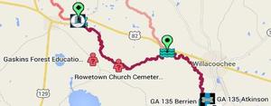 Update from expedition leader Bret Wagenhorst:
The current weather forecast for Saturday in Alapaha, GA is cloudy with 20% chance of thunderstorms. The water level on the Alapaha River at the Alapaha gauge
is 9.4 ft and appears to be plateauing. [The river has already been going down for a couple of days upstream at the Irwinville gauge. -jsq] Unless there are heavy rains in or north of Alapaha Friday, we should be able to proceed with our planned outing.
It should be a fast trip with the water this high, and with fast, high water comes increased risk, so this is probably not a great outing for a beginner.
Know that the put in is actually Continue reading
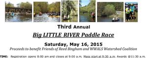
Poster for the Third Annual BIG Little River Paddle Race 2015-05-16
 Pregistration remains open throughout April for the May 16th paddle race
at Reed Bingham State Park, to benefit WWALS and FORBS.
Sunshine, great blue herons, turtles, and good fun.
Pregistration remains open throughout April for the May 16th paddle race
at Reed Bingham State Park, to benefit WWALS and FORBS.
Sunshine, great blue herons, turtles, and good fun.
Bret Wagenhorst says:
Feel free to share it with whomever might be interested and to post it on the web or on walls wherever it might get some attention.
You can register online, or print the registration form at that link and mail in with a check. Preregistration lasts through April ($20 per boat plus $5/vehicle park entrance fee).
The price goes up after May 1st or at the event ($30/boat plus $5/vehicle), 8AM Saturday morning May 16th 2015 at Red Roberts Landing on Rountree Bridge Road off I-75 Exit 41.
Printable PDF.
JPG image: Continue reading
Rowetown Church to GA 135: WWALS April outing 2015-04-18
Update 2015-04-17: Water’s high, but looks like the outing is on.
 Paddle downstream on the Alapaha River past the Willacoochee River
and the city of Willacoochee,
among ancient cypress, pines, turtles, fish, and birds.
This is a long one, so come prepared:
water, snacks, and as always personal flotation devices.
It’s also remote and possibly difficult with deadfalls,
so please be able to swim or at least float.
If you need a boat, please contact wwalswatershed@gmail.com.
Facebook event.
Paddle downstream on the Alapaha River past the Willacoochee River
and the city of Willacoochee,
among ancient cypress, pines, turtles, fish, and birds.
This is a long one, so come prepared:
water, snacks, and as always personal flotation devices.
It’s also remote and possibly difficult with deadfalls,
so please be able to swim or at least float.
If you need a boat, please contact wwalswatershed@gmail.com.
Facebook event.
| When: | 8AM April 18th 2015 |
|---|---|
| Shuttle: | 40 min. shuttle |
| Start: | 9AM on the water |
| Duration: | approximately 4 hour paddle |
| Stop: | About 1PM |
| Where: | Rowetown Church Cemetery,
7 miles east of Alapaha, GA via Moore Sawmill Road, on Rowetown Church Road, Berrien County, GA 31.33906, -83.149789 |
This event is FREE! All we ask is that Continue reading
A Day in the Woods at Gaskins Forest Education Center 2015-04-18
The Gaskins Forest Education Center invites you to A Day in the Woods: Forestry and Wildlife Activities for All the Family, on Saturday, April 18 from 9 am to 3 pm.
Educators interested in botany, forestry, wildlife, hydrology, and geology may want to take this opportunity to come out on April 18th and see the potential for planning and carrying out future teacher-led outdoor classroom activities.
This is a free community event Continue reading
Third Annual BIG Little River Paddle Race
Saturday May 16th 2015 at Reed Bingham State Park,
 you can join the annual fun paddling down our south Georgia blackwater Little River
past herons and alligators to the lake in Reed Bingham State Park, between Adel and Moultrie, equidistant from Tifton and Valdosta.
you can join the annual fun paddling down our south Georgia blackwater Little River
past herons and alligators to the lake in Reed Bingham State Park, between Adel and Moultrie, equidistant from Tifton and Valdosta.
You can register online or at the event.
-jsq