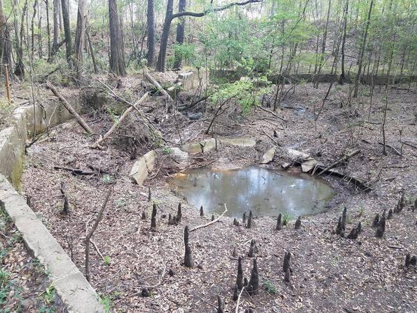
Sabal Trail has hidden the “depressions” they admitted to recently.

Updated 2017-05-23: Clarify what the google map is about.
See the Continue reading

Sabal Trail has hidden the “depressions” they admitted to recently.
Updated 2017-05-23: Clarify what the google map is about.
See the Continue reading
Received Friday:
Today Sabal Trail workers were clearing underbrush and small trees on the bank of the Suwannee River where the pipeline is installed under the river to install a sign. I could not see what the sign said, the sign was on the ground with the words facing down.

Correct me if I am wrong, but didn’t STT say Continue reading

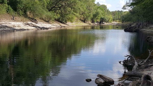
Lots more pictures now posted of this sunny Suwannee River outing past springs and sand like snow, plus Hands Across the Sand.
-jsq, John S. Quarterman, Suwannee RIVERKEEPER®
You can join this fun and work by becoming a WWALS member today!
Local cave diver Aaron Sirmons took these pictures and videos of the formerly famous Wade Springs of Brooks County, Georgia, between Blue Springs Road and the railroad, west of the Withlacoochee River. He has a letter of permission from the landowner.
These aerial photographs by Beth Gammie cover the route of the Saturady 20 May 2017 WWALS Outing down the Suwannee River from Woods Ferry Tract Launch to Suwannee Springs. She took them for WWALS 23 November 2016, on a Southwings flight piloted by Roy Zimmer. They’re all looking from Hamilton County south (or west) across the Suwannee River into Suwannee County.
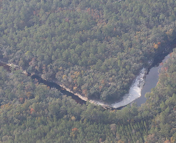
I have pulled out a few detail shots, of Woods Ferry Tract Launch and of Suwannee Springs.
Update 2023-04-13: Pictures.
Due to low water, we’re moving the May 20th outing downstream! With lunch, swim stops, and bon-bons, of course. Bring bug spray and the usual personal flotation device, boat paddles, food, drinking water, warm clothes, and first aid kit. If you don’t have a boat, there are many outfitters, or let us know and many of us have spare boats.
Two outfitters advise there should be enough water on this route to avoid much boat dragging. There is a slight 30% possibility of afternoon thunder showers. Same date, same time, same river: just a bit downstream.
When:
9AM Saturday May 20, 2017, meet to shuttle
10AM: Start paddling
12PM noon: Stop for Hands Across the Sand
“Say NO to dirty fuels and YES to clean energy”
2-3PM: Finish some time around then
Put In: Mile 158.0, Woods Ferry Tract Launch, in Suwannee County, Florida
GPS of Entrance: to Woods Ferry Tract 30.343508, -82.855187
Paddle Distance: 8.0 river miles
Paddle Duration: 4 hours
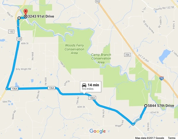
Directions to Put In: From Live Oak, travel north on Continue reading
With reference Yellow Dog.
Taken from Tyler Bridge on river mile 78.71 at Franklinville Road.
-jsq, John S. Quarterman, Suwannee RIVERKEEPER®
You can join this fun and work by becoming a WWALS member today!
Update 2017-05-17: OK, the water’s gotten too low at the original location, so we’re moving downstream to Woods Ferry Tract Launch to Suwannee Springs.
Hands Across the Sand on the Suwannee Saturday! The river is quite low (48.78 feet NAVD on the White Springs gage), but it looks doable from the put-in and take-out. A ranger at Stephen Foster State Park told me paddling from White Springs to Swift Creek would be doable, perhaps with a few dry spots. I’ll also call a local outfitter or two for their opinions.
Meanwhile, bring bug spray (gnats) and a rope (to pull your boat over sand bars), and we’re still on for 9AM Saturday 20 May 2017. See the outing announcement for more details.
Plus: that’s the day of Hands Across the Sand, “Say NO to dirty fuels and YES to clean energy”. WWALS has been saying that for years, so somewhere on the Suwannee we will stop and do Hands Across the Sand against the Sabal Trail fracked methane pipeline and for solar power.
The VDT and the City of Valdosta are feuding again about water quality,
this time about drinking water (not sewage).
 They’re both wrong and both right, and neither named
any of the other poor local water sources.
The VDT didn’t make this story easy to follow by omitting the key piece
from its first online story and not quoting its source,
and the city didn’t acknowledge some main points the VDT made.
They’re both wrong and both right, and neither named
any of the other poor local water sources.
The VDT didn’t make this story easy to follow by omitting the key piece
from its first online story and not quoting its source,
and the city didn’t acknowledge some main points the VDT made.
Kimberly Cannon, Valdosta Daily Times, 10 May 2017, City celebrates water: Mayor refutes water quality report, Continue reading
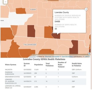
Valdosta indeed didn’t have the worst water treatment violations in Lowndes County, Georgia, but it was worse than any nearby city in Georgia or Florida (and Lowndes County was worse than any nearby county). Once again, the Valdosta Daily Times said (twice) that Valdosta “is now in full compliance”. This is about drinking water treatment; sewage is another story. But in both cases, if Valdosta doesn’t want the local newspaper to treat the city as the villain of the piece, maybe it should stop reacting like one.

The above screenshot from Threats on Tap: Widespread Violations Highlight Need for Investment in Water Infrastructure and Protections shows Georgia has been pretty bad, but Florida was much worse.
Let’s look at the area around Valdosta. Continue reading
