
 See three sinks, a waterfall, and a distributary in these videos from the
WWALS Outing to Turket Creek Waterfall, the Alapahoochee River,
the Alapaha River Sink, and the Dead River Sink, June 14, 2015.
A WWALS video playlist
follows the links to each video below. Continue reading
See three sinks, a waterfall, and a distributary in these videos from the
WWALS Outing to Turket Creek Waterfall, the Alapahoochee River,
the Alapaha River Sink, and the Dead River Sink, June 14, 2015.
A WWALS video playlist
follows the links to each video below. Continue reading
Tag Archives: Alapaha River Sink
Pictures: Alapaha and Dead River Sinks 2016-11-06
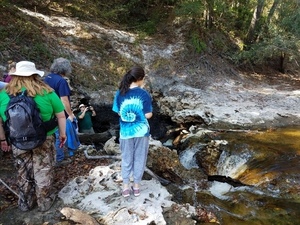 A very scenic hike to some of the most unusual geological features in all of Florida: the Alapaha River Sink and the Dead River Sink.
We walked over beds of 50-million-year-old fossilized oysters,
above all our drinking water in the Floridan Aquifer.
See many pictures
and
a few videos of the sights,
and
a google map
of the sites.
A very scenic hike to some of the most unusual geological features in all of Florida: the Alapaha River Sink and the Dead River Sink.
We walked over beds of 50-million-year-old fossilized oysters,
above all our drinking water in the Floridan Aquifer.
See many pictures
and
a few videos of the sights,
and
a google map
of the sites.
Practicing Geologist Dennis Price led us by the scenic route on this hike, explaining the karst geology on display, which underlies all of north Florida and south Georgia, containing our drinking water in the Floridan Aquifer. Dennis and hike organizer Chris Mericle recommend making this very unusual area a state park.
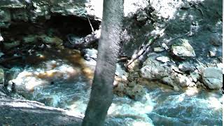
The Alapaha River goes underground here unless it has a lot of water, which usually this time of year and right now it does not.
![[Don't fall into the Devil's Den, 30.5855189, -83.0528064]](https://www.wwals.net/pictures/2016-11-06--alapaha-sink/20161106_111756.jpg)
Don’t fall into the Devil’s Den, 30.5855189, -83.0528064
Update 2022-11-17: The Jennings Gauge read 61.70′ NAVD88.
Until recently nobody knew for sure Continue reading
Dead River Sink, Alapaha River, WWALS Outing, 2PM 26 Oct 2014
This Sunday afternoon, Oct 26th at 2PM:
where the Dead River meets the Alapaha River and goes underground
at the Dead River Sink, aka the Alapaha Sink.
 Park on SRWMD’s Jennings Bluff Tract and walk in with WWALS
to see what Samuel Taylor Coleridge dreamed as
“Where Alph, the sacred river, ran
Through caverns measureless to man
Down to a sunless sea.”
No boat required: this is a walking outing.
Park on SRWMD’s Jennings Bluff Tract and walk in with WWALS
to see what Samuel Taylor Coleridge dreamed as
“Where Alph, the sacred river, ran
Through caverns measureless to man
Down to a sunless sea.”
No boat required: this is a walking outing.
It’s an adventure, as Deanna Mericle reported recently:
…the hike to the sink does have some steep parts, especially if you go the scenic route, which I recommend. The area around the sink itself is kind of steep with slick mud/clay. So wear good shoes for hiking. There were only a few Mosquitos. The area is beautiful and worth the effort.
This event is FREE! All we ask is Continue reading
Alapaha Sink: WWALS Outing 2PM 26 Oct 2014
Update 24 October 2014: Map, directions, and how to join WWALS.
Come see where the Alapaha River goes underground, near Jennings, in Hamilton County, Florida, 2PM, Sunday, October 26th, 2014. This is a walking outing; no boats required.
Directions to the parking area:
Take I-75 south to State Road 6 in Florida. Go east (left) to US 41.
Go north (left) about one mile. Turn right on NW 76th Terrace and go
a mile. Turn right on NW 25th Lane and go about a mile.
 Turn left at
the Jennings Bluff Tract sign and go .9 mile. It dead ends at the
parking area. That road is gravel and dirt and kinda bumpy. The
parking area can probably hold ten vehicles at least.
Turn left at
the Jennings Bluff Tract sign and go .9 mile. It dead ends at the
parking area. That road is gravel and dirt and kinda bumpy. The
parking area can probably hold ten vehicles at least.
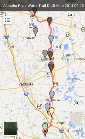
The location for the Sink on the draft Alapaha River Water Trail map apparently Continue reading