Tag Archives: Hawthorne formation

Proposal for the Recharge of the Upper Floridan Aquifer –D.J. Price P.G. 2016-11-14

Dennis J. Price, P.G., sent this proposal to the committee for the North Florida Regional Water Supply Plan (NFRWSP), and that WWALS included in our comments.

They duly noted it in their matrix of comments. But, so far as I can tell, they did not follow any of its recommendations.

[Map and Proposal]
Map and Proposal

See also Dennis’s other letter on this subject.


SE ENVIRONMENTAL GEOLOGY
DENNIS J. PRICE, P.G.
P.O. BOX 45
WHITE SPRINGS, FL 32096
cell 362-8189, den1@windstream.net
Recharge-Proposal.pdf

November 14, 2016

North Florida Regional Water Supply Partnership

RE: PROPOSAL FOR THE RECHARGE OF THE UPPER FLORIDAN AQUIFER IN THE NORTH FLORIDA FLATWOODS ENVIRONMENT, HAMILTON, COLUMBIA, UNION, BAKER AND ALACHUA COUNTIES.

My proposal is directed towards those areas in the SRWMD and the SIRWMD that are underlain by the Hawthorn formation resulting in extensive areas containing a surficial aquifer and the intermediate aquifers that exist in the Hawthorn. Recharge to the Floridan is retarded by the presence of the clay layers in the Hawthorn. Very large wetland systems are common in these areas.

Water balance studies were produced twice that I am aware of in the SRWMD, one by Continue reading

WWALS at VSU Learning in Retirement 2017-08-31

Come ask Gretchen questions this Thursday morning, 10-11AM, at VSU’s Continuing Education building in midtown Valdosta.

When: 10AM to 11AM, Thursday, August 31, 2017

Where: VSU Continuing Education
903 N Patterson St, Valdosta, Georgia 31698

Event: facebook

Gretchen Quarterman, Executive Director, WWALS Watershed Coalition
Gretchen Quarterman speaking at a WWALS public meeting at VSU last spring

WWALS will be offering an interactive lecture at Valdosta State Learning in Retirement Fall Session. We will talk about the watershed of the Suwannee Basin, the Floridan Aquifer, current challenges, and how together we can make sure our water is swimmable, fishable, and drinkable.

Continue reading

Pictures: Alapaha and Dead River Sinks 2016-11-06

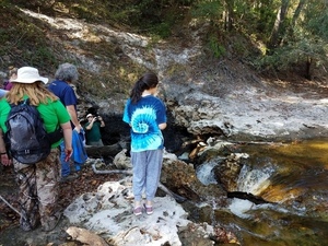
the Alapaha River sink, 30.5855189, -83.0528064 A very scenic hike to some of the most unusual geological features in all of Florida: the Alapaha River Sink and the Dead River Sink. We walked over beds of 50-million-year-old fossilized oysters, above all our drinking water in the Floridan Aquifer. See many pictures and a few videos of the sights, and a google map of the sites.

Practicing Geologist Dennis Price led us by the scenic route on this hike, explaining the karst geology on display, which underlies all of north Florida and south Georgia, containing our drinking water in the Floridan Aquifer. Dennis and hike organizer Chris Mericle recommend making this very unusual area a state park.

The Alapaha River goes underground here unless it has a lot of water, which usually this time of year and right now it does not.

[Don't fall into the Devil's Den, 30.5855189, -83.0528064]
Don’t fall into the Devil’s Den, 30.5855189, -83.0528064

Update 2022-11-17: The Jennings Gauge read 61.70′ NAVD88.

Until recently nobody knew for sure Continue reading