Tag Archives: Falling Creek

Pictures: Portage Big Shoals, Paddle Little Shoals, Suwannee River 2023-05-20

We saw the lally columns of Old Godwin Bridge, Bell Springs Run, Robinson Creek, Falling Creek, and we portaged around Big Shoals and paddled through Little Shoals, on the Suwannee River to White Springs Wayside Park Ramp, in a WWALS outing, Saturday, May 20, 2023.

[Launch, Big Shoals, Little Shoals, Falling Creek, Wayside Park, Suwannee River 2023-05-20]
Launch, Big Shoals, Little Shoals, Falling Creek, Wayside Park, Suwannee River 2023-05-20

Everyone had a good time in the balmy, breezy, partly-cloudy weather. The White Springs Gauge read 51.5 feet, which was perfect.

Plus a few small alligators.

Thanks to Dennis James Price for leading this one, and for pointing out the excellent lunch spot just below Big Shoals. Continue reading

Big Shoals and Little Shoals, Suwannee River, 2023-05-20

Update 2023-05-30: Pictures: Portage Big Shoals, Paddle Little Shoals, Suwannee River 2023-05-20.

Join us as we portage around Big Shoals, the biggest rapids in Florida, and paddle through Little Shoals on the Suwannee River.

Practicing Geologist Dennis J. Price of Hamilton County will lead us past the lally columns of Old Godwin Bridge. Two thirds of a mile later, we will take out just before Big Shoals, and portage a quarter mile through the woods. Paddlers in good health should be able to do this. We do not recommend it for small children. We will be portaging: if you want to paddle through Big Shoals, do it on a different trip.

Then we’ll paddle past several creeks, including Bell Springs Run and Falling Creek.

About 3.5 miles downstream from Big Shoals, we’ll paddle through Little Shoals, which can get up to Class II rapids. Plus there’s another little rapid just before the railroad bridge and the US 41 bridge.

When: Gather 9 AM, launch 10 AM, end 2 PM, Saturday, May 20, 2023

Put In: Big Shoals Tract Launch, From White Springs, travel north on CR 135 to SE 94 Street (Godwin Bridge Road); turn right and follow road to Big Shoals, in Hamilton County, Florida.

GPS: 30.353167, -82.687333

[Big Shoals pictures from 2021-05-19]
Big Shoals pictures from 2021-05-19

Continue reading

Water budget, limit water withdrawals, do better aquifer recharge –WWALS to NFRWSP 2023-01-31

Update 2023-09-14: Draft 2023 North Florida Regional Water Supply Plan (NFRWSP) workshop 2023-09-21.

Sent as PDF.


January 31, 2023

To: SRWMD, SJRWMD, partnership@sjrwmd.com

Re: Water budget, limit water withdrawals, do better aquifer recharge, NFRWSP

Dear Water Management Districts,

Thank you for the opportunity for public input.

[Not every demand needs water withdrawals]
Not every demand needs water withdrawals

At the November 15, 2022, public meeting about the North Florida Regional Water Supply Plan (NFRWSP), I thanked the presenters for all the hard work they had put into the details, such as in the North Florida-Southeast Georgia (NFSEG) regional groundwater flow model .

I have some issues with another level. I noticed repeated assertions in the public meeting that demand or projected demand are just taken as givens. So basically anybody who wants to build a golf course, or start another titanium mine, or plant almond trees that need lots of water, that’s just a given, that’s demand.

Continue reading

Videos: North Florida Regional Water Supply Plan meeting @ SRWMD 2022-11-15

Update 2023-02-07: Water budget, limit water withdrawals, do better aquifer recharge –WWALS to NFRWSP 2023-01-31.

Almost all the attendees were SRWMD staff; no board members. The only public comment was by me, at the NFRWSP Constraint Meeting, at SRWMD HQ yesterday.

You can comment in writing to partnership@sjrwmd.com by January 31, 2023.

[Presenters, Commenter]
Presenters, Commenter

The presentations were informative, although they omitted a major subject, which I addressed: limits on water withdrawal permits. Will the SRWMD and SJRWMD boards address it this time, or shrug it off like six years ago, after many people suggested it?

SRWMD seemed to be recording video of this meeting, and presumably they will release the slides sometime. Meanwhile, pictures of most of the slides are on the WWALS website. Here is a a WWALS video playlist: Continue reading

NFRWSP Constraint Meeting, 2022-11-15

Update 2022-11-16: Videos: North Florida Regional Water Supply Plan meeting @ SRWMD 2022-11-15.

Update 2022-11-15: Figures and Tables from NORTH FLORIDA SOUTHEAST GEORGIA GROUNDWATER MODEL (NFSEG V1.1) 2019-08-01.

January will be six years since SRWMD and SJRWMD passed the North Florida Regional Water Supply Plan (NFRWSP), mostly ignoring input from interested parties. It’s back for renovations, with public comment at the end of the workshops. Maybe you’d like to attend and comment, or send them written comments.

When: 2 PM, Tuesday, November 15, 2022

Put In: District Headquarters, 9225 CR 49, Live Oak, FL 32060

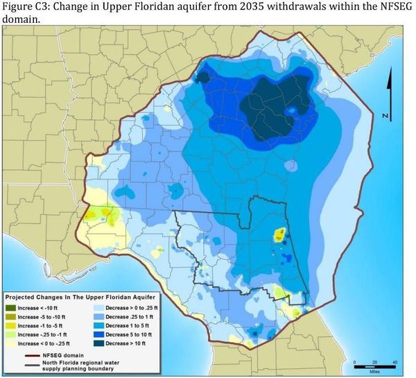
Figure C3: Aquifer surface change due to withdrawals in north Florida and south Georgia

Continue reading

Proposal for the Recharge of the Upper Floridan Aquifer –D.J. Price P.G. 2016-11-14

Dennis J. Price, P.G., sent this proposal to the committee for the North Florida Regional Water Supply Plan (NFRWSP), and that WWALS included in our comments.

They duly noted it in their matrix of comments. But, so far as I can tell, they did not follow any of its recommendations.

[Map and Proposal]
Map and Proposal

See also Dennis’s other letter on this subject.


SE ENVIRONMENTAL GEOLOGY
DENNIS J. PRICE, P.G.
P.O. BOX 45
WHITE SPRINGS, FL 32096
cell 362-8189, den1@windstream.net
Recharge-Proposal.pdf

November 14, 2016

North Florida Regional Water Supply Partnership

RE: PROPOSAL FOR THE RECHARGE OF THE UPPER FLORIDAN AQUIFER IN THE NORTH FLORIDA FLATWOODS ENVIRONMENT, HAMILTON, COLUMBIA, UNION, BAKER AND ALACHUA COUNTIES.

My proposal is directed towards those areas in the SRWMD and the SIRWMD that are underlain by the Hawthorn formation resulting in extensive areas containing a surficial aquifer and the intermediate aquifers that exist in the Hawthorn. Recharge to the Floridan is retarded by the presence of the clay layers in the Hawthorn. Very large wetland systems are common in these areas.

Water balance studies were produced twice that I am aware of in the SRWMD, one by Continue reading

The NFRWSP’s job is to figure out how to increase water levels in the aquifer. –Dennis J. Price 2016-12-12

This is a letter Practicing Geologist Dennis J. Price wrote for publication.

December 12, 2016

RE: North Florida Regional Water Supply Partnership

About 5 years ago, a report prepared for the Suwannee River Water Management District (SRWMD) indicated that under North Columbia County, East Hamilton County and Baker County, ground water levels in the Floridan aquifer (the aquifer the majority of us citizens get our water from) had dropped about 20 feet, more or less. The effects of the loss of that 20 feet was first felt and is very obvious in White Springs, 13 miles north of Lake City. The spring quit flowing for all intents and purposes. Tourism and the Towns economy plummeted.

[2019-04-03 White Sulfur Spring Flowing]
2019-04-03 White Sulfur Spring Flowing, so unusual an event it was reported for SRWMD by their Senior Hydrologist Fay Baird.

The report placed the greatest blame for the drawdown on water use by the coastal communities of South Georgia and North Florida. Scientists from the St. John’s River Water Management District (SJRWMD) at first concurred with this assessment. After objections from the Jacksonville Electric Authority (JEA) and the removal of several key employees at the SJRWMD, the SJRWMD said they weren’t sure anymore and a study needed to be done.

So, you guessed it, a committee was formed, The North Florida Regional Water Supply Partnership (NFRWSP). Don’t get me wrong regarding this committee, it is probably the single most important committee ever formed in our area. Their plans will affect the continued growth of North Florida communities along with the economy and recreational opportunities in our lakes and rivers.

Figure C3: Aquifer surface change due to withdrawals in north Florida and south Georgia

The NFRWSP’s job Continue reading

World’s largest phosphate company after 20 years loses to DeSoto County, FL

The bigger they are, the harder they fall. Mosaic Co., market cap $11.5 billion, just lost to DeSoto County, Florida, annual budget $84.3 million. Maybe this will help Bradford County to do the right thing about phosphate mines.

Craig Pittman, Tampa Bay Times, 26 July 2018, Mosaic spent 20 years planning new phosphate mine. DeSoto County has rejected it,

Mosaic Co., the world’s largest phosphate company, has spent two decades lining up a new mine in DeSoto County as part of a broader effort to move its operations south.

W across PCS Phosphate Mine,
Photo: Jim Tatum on Southwings flight for WWALS, 2016-10-22: W across PCS Phosphate Mine, 30.4429360, -82.7851800

But DeSoto County commissioners last week slammed the door in the company’s face, voting 4-1 against rezoning 18,000 acres from agricultural to mining.

A major concern: Continue reading

Nutrien (PCS) mining phosphate and water in Hamilton County and soon in Columbia County? 2018-07-11

Update 2023-05-08: Fixed some images.

Five Years Later: Hamilton County Planning Commission wants conditions on Nutrien phosphate mine permit renewal 2023-03-28.

See also: PCS Phosphate Mine dragline access permit application SAJ-1984-04652 2019-10-15.

Thanks to Jim Tatum of OSFR for spotting this op-ed in the Lake City Reporter yesterday by WWALS member and Practicing Geologist Dennis J. Price of Hamilton County, Florida about Nutrien (PCS) mining phosphate and water in Hamilton County and likely planning to expand to Columbia County.

[Dennis Price explains, 13:50:12, 30.57871, -83.05231]
Photo by John S. Quarterman of Dennis J. Price at the Dead River of the Alapaha River, 2018-01-27.

To the Editor:

Much has been written in the last year about Sam Oosterhoudt’s mitigation bank. I was involved in permitting the bank through the Army Corps (ACOE) and The Florida Department of Environmental Regulation. It took about 5 years to get all the permits. Now, 9 years after work began on the project, the phosphate company (then PCS now Nutrien) petitioned the state to shut down the mitigation bank.

I do not know for sure, but, Nutrien may tell you that during the recent sale of PCS and the review of mineral interests owned, they discovered that the mitigation bank had snuck in there and set up shop over their minerals. This probably has some truth to it but I think there is a much more involved reason.

In Hamilton County, Nurtrien/PCS is planning to run out of phosphate to mine in about 10 years, give or take a few years either way. I do not believe they are planning on shutting the doors and leaving. Occidental Chemical Company started mining in Hamilton County Continue reading

Less withdrawals, more water retention for North Florida Regional Water Supply Plan: WWALS PR 2016-12-06

FOR IMMEDIATE RELEASE

Jasper, Florida, November 6th 2016 — Better modeling and measurement of more water reuse and retention with fewer water withdrawals in both north Florida and south Georgia, WWALS Watershed Coalition (WWALS) recommended yesterday in comments (PDF) on the North Florida Regional Water Supply Plan (NFRWSP). WWALS also opposed the Falling Creek Aquifer Storage project and suggested a replacement, and recommended including threats to the FLoridan Aquifer and the Suwannee, Withlacoochee, and Alapaha Rivers such as pipelines and fracking.

Figure C3: Aquifer surface change due to withdrawals in north Florida and south Georgia WWALS applauded water supply projects involving reuse or stormwater, especially those in Jacksonvile and Gainesville, two of the sources of the general problem of falling water levels in the Floridan Aquifer. WWALS also applauded the plan to set minimum flow levels on the upper Suwannee River and WWALS expects to be involved with that.

WWALS recommended expanding the original study area, which stopped at the Suwannee River on the west and the Georgia-Florida state line on the north. WWALS president John S. Quarterman explained,

“Our rivers don’t stop because there’s a state line on a map, and there are three second-magnitude springs on the Withlacoochee River in Georgia south of Valdosta, one of them with a more than 4,000-foot cave system, that aren’t taken into account in this draft plan.”

Quarterman elaborated on a much larger concern: Continue reading