Tag Archives: Dennis J. Price

Draft 2023 North Florida Regional Water Supply Plan (NFRWSP) workshop 2023-09-21

Update 2023-09-14: Now with Agenda.

Return of the massive 2017 North Florida Regional Water Supply Plan (NFRWSP) that did nothing to stop lowering water levels or nitrates leaching into springs and rivers.

DATE AND TIME: Thursday, September 21, 2023, Posterboard Session starts at 5:45 p.m. and the Webinar Presentation starts at 6:30 p.m.

Where: SRWMD, 9225 CR 49, Live Oak, FL 32060

Or by webinar: https://attendee.gotowebinar.com/register/2570768570283041622

[Potential evaporation map 2019-08-01 with joint SRWMD SJRWMD NFRWSP approval meeting 2017-01-17]
Potential evaporation map 2019-08-01 with joint SRWMD SJRWMD NFRWSP approval meeting 2017-01-17

As I wrote SRWMD and SJRWMD this January, “I have some issues with another level. I noticed repeated assertions in the public meeting that demand or projected demand are just taken as givens. So basically anybody who wants to build a golf course, or start another titanium mine, or plant almond trees that need lots of water, that’s just a given, that’s demand.”

I continue to agree with Dennis J. Price, P.G., of Hamilton County, Florida (now a WWALS Board member), Continue reading

Valdosta Lee Street Detention Pond Trash Trap –Florida Specifier 2023-05-03

This brief mention in a Florida state-wide bi-monthly environmental review newspaper is mostly right as far as it goes. Many more people and some personnel changes at the city of Valdosta were involved.

[Valdosta Lee Street Detention Pond Trash Trap and Florida Specifier article]
Valdosta Lee Street Detention Pond Trash Trap and Florida Specifier article

Florida Specifier, April-May 2023, Valdosta trapping trash from entering waterways, Continue reading

Big Shoals and Little Shoals, Suwannee River, 2023-05-20

Update 2023-05-30: Pictures: Portage Big Shoals, Paddle Little Shoals, Suwannee River 2023-05-20.

Join us as we portage around Big Shoals, the biggest rapids in Florida, and paddle through Little Shoals on the Suwannee River.

Practicing Geologist Dennis J. Price of Hamilton County will lead us past the lally columns of Old Godwin Bridge. Two thirds of a mile later, we will take out just before Big Shoals, and portage a quarter mile through the woods. Paddlers in good health should be able to do this. We do not recommend it for small children. We will be portaging: if you want to paddle through Big Shoals, do it on a different trip.

Then we’ll paddle past several creeks, including Bell Springs Run and Falling Creek.

About 3.5 miles downstream from Big Shoals, we’ll paddle through Little Shoals, which can get up to Class II rapids. Plus there’s another little rapid just before the railroad bridge and the US 41 bridge.

When: Gather 9 AM, launch 10 AM, end 2 PM, Saturday, May 20, 2023

Put In: Big Shoals Tract Launch, From White Springs, travel north on CR 135 to SE 94 Street (Godwin Bridge Road); turn right and follow road to Big Shoals, in Hamilton County, Florida.

GPS: 30.353167, -82.687333

[Big Shoals pictures from 2021-05-19]
Big Shoals pictures from 2021-05-19

Continue reading

Water budget, limit water withdrawals, do better aquifer recharge –WWALS to NFRWSP 2023-01-31

Update 2023-09-14: Draft 2023 North Florida Regional Water Supply Plan (NFRWSP) workshop 2023-09-21.

Sent as PDF.


January 31, 2023

To: SRWMD, SJRWMD, partnership@sjrwmd.com

Re: Water budget, limit water withdrawals, do better aquifer recharge, NFRWSP

Dear Water Management Districts,

Thank you for the opportunity for public input.

[Not every demand needs water withdrawals]
Not every demand needs water withdrawals

At the November 15, 2022, public meeting about the North Florida Regional Water Supply Plan (NFRWSP), I thanked the presenters for all the hard work they had put into the details, such as in the North Florida-Southeast Georgia (NFSEG) regional groundwater flow model .

I have some issues with another level. I noticed repeated assertions in the public meeting that demand or projected demand are just taken as givens. So basically anybody who wants to build a golf course, or start another titanium mine, or plant almond trees that need lots of water, that’s just a given, that’s demand.

Continue reading

NFRWSP Constraint Meeting, 2022-11-15

Update 2022-11-16: Videos: North Florida Regional Water Supply Plan meeting @ SRWMD 2022-11-15.

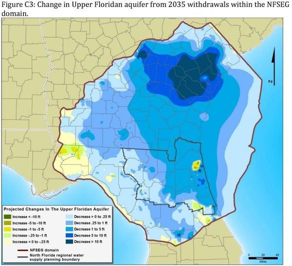
Update 2022-11-15: Figures and Tables from NORTH FLORIDA SOUTHEAST GEORGIA GROUNDWATER MODEL (NFSEG V1.1) 2019-08-01.

January will be six years since SRWMD and SJRWMD passed the North Florida Regional Water Supply Plan (NFRWSP), mostly ignoring input from interested parties. It’s back for renovations, with public comment at the end of the workshops. Maybe you’d like to attend and comment, or send them written comments.

When: 2 PM, Tuesday, November 15, 2022

Put In: District Headquarters, 9225 CR 49, Live Oak, FL 32060

Figure C3: Aquifer surface change due to withdrawals in north Florida and south Georgia

Continue reading

Hike: Bell Springs to Big Shoals, Suwannee River 2022-03-19

Due to high water, we have rescheduled the Saturday paddle to become a 2-hour easy hike from Bell Springs to Big Shoals on the Suwannee River, led by Practicing Geologist Dennis J. Price of Hamilton County, Florida. Here’s a way to see Florida’s only Class III rapids with no need for a boat.

When: Gather 8 AM, caravan 9 AM, hike 9:30 AM, end 12 PM, Saturday, March 19, 2022

Put In: Nature & Heritage Tourism Center, 10499 Spring St, White Springs, FL 32096, at the corner of Bridge and Spring Street.

GPS: 30.32947, -82.759426

Take Out: Meet at the Tourism Center, sign in, and Dennis will lead a caravan to Bell Springs, where the hike begins and ends.

Bring: hiking boots and clothes, drinking water, and first aid kit. Also trash pickers and trash bags: every WWALS outing is also a cleanup.

Free: This outing is free to WWALS members, and $10 (ten dollars) for non-members. You can pay the $10 at the outing, or online:
https://wwals.net/outings

We recommend you support the work of WWALS by becoming a WWALS member today!
https://wwals.net/donations/#join

Event: facebook, meetup

[Map: Bell-Springs to Big Shoals]
Map: Bell-Springs to Big Shoals

Continue reading

Bridge to Bridge Suwannee River paddle for White Springs Wild Azalea Festival 2022-03-19

Update 2022-03-15: Due to high water, replaced by Hike: Bell Springs to Big Shoals, Suwannee River 2022-03-19.

Join us for a geologic education paddle through millions of years, on a scenic two-mile stretch of the Suwannee River. Led by Practicing Geologist Dennis J. Price of Hamilton County, Florida, we will pass White Sulphur Spring, the first Floridan Aquifer Spring encountered on the Suwannee River.

Once you land, you can go on up to the Wild Azalea Festival! The festival is conveniently located at the corner of Spring and Bridge Street, 10499 Spring St, White Springs, FL 32096.

[US 41 Bridge past FL 136 Bridge, Suwannee River, White Springs, Florida]
US 41 Bridge past FL 136 Bridge, Suwannee River, White Springs, Florida

Dennis Price explains, “For millions of years, Florida was a limestone platform not connected to the now North American continent. For eons the limestone bed would emerge, the bed surface would erode then sink again, several times. Each time the limestone would build again with a different set of fossils. The last limestone bed to deposit was the Suwannee Limestone. Florida thru this time was separated from the continent by the Suwannee Straits, similar to the Florida straits separating Florida from Cuba. Erosional sediments from the continent was slowly filling the Straits and when finally filled, sediments began covering the limestone that was Florida. These sediments are known as the Hawthorne formation today.”

When: Gather 8 AM, launch 8:30 AM, end 10 AM, Saturday, March 19, 2022

Put In: Suwannee River Wayside Park Ramp @ US 41. From White Springs, travel south on US 41 to the river; the ramp is on the south side in the town park, in Hamilton County.
This is where the Suwannee River Wilderness Trail officially starts, although the WWALS web pages and map include the entire river up into Georgia and the Okefenokee Swamp.

GPS: 30.3255, -82.739167 ,

Take Out: Stephen Foster Folk Culture Center State Park Launch, 11016 Lillian Saunders Drive/U.S. Highway 41, White Springs FL 32096.
$5.00 per vehicle (up to 8 people) State Park entry fee.

White Sulphur Springs is after the second bridge but before the takeout. It was one of the first tourist attractions in Florida. Nowadays you can visit the empty bathhouse, see the trickle of water coming out, and read what Dennis wrote: The NFRWSP’s job is to figure out how to increase water levels in the aquifer. –Dennis J. Price 2016-12-12.

Bring: the usual personal flotation device, boat, paddles, food, drinking water, warm clothes, and first aid kit. Also trash pickers and trash bags: every WWALS outing is also a cleanup. Mosquitoes can be bad at dusk so come prepared.

Free: This outing is free to WWALS members, and $10 (ten dollars) for non-members. You can pay the $10 at the outing, or online:
https://wwals.net/outings

We recommend you support the work of WWALS by becoming a WWALS member today!
https://wwals.net/donations/#join

Continue reading

Worse than Falling Creek: SRWMD wants to pipe Suwannee River water twice to Ichetucknee Springs 2021-06-08

Four years ago SRWMD proposed to pipe Suwannee River water from near White Springs to a sinkhole near Falling Creek to replenish the Ichetucknee River. Now the District has come up with something worse: not one, but two pipelines, adding one from Branford, both to spread water on the ground nearer the Ichetucknee headspring. SRWMD told reporters these were just tentative plans, but SRWMD’s own slides lay out a process just like four years ago when a plan was rubberstamped by SRWMD and SJRWMD despite numerous objections. Head it off now!

Here are some easier, less costly, and simpler methods than pipeline boondoggles: send pine plantation ditch water into the aquifer; three ways to limit water withdrawals, and Right to Clean Water.

[Map: Recharge %]
Map: Recharge % in SRWMD’s slides Prevention and Recovery Strategy for the Lower Santa Fe and Ichetucknee Rivers and Priority Springs.

What we wrote four years ago applies twice as much this time:

“The Falling Creek project has very large up-front expense, involves environmental risk in running a large-diameter pipe through wetlands, and has high maintenance cost. In addition it only benefits the Ichetucknee Springs watershed. It is seasonal, for instance at the water levels now in the Suwannee, there is no water to pump to Falling Creek.”

Back then we included in our comments to SRWMD a much simpler and less costly proposal Continue reading

Proposal for the Recharge of the Upper Floridan Aquifer –D.J. Price P.G. 2016-11-14

Dennis J. Price, P.G., sent this proposal to the committee for the North Florida Regional Water Supply Plan (NFRWSP), and that WWALS included in our comments.

They duly noted it in their matrix of comments. But, so far as I can tell, they did not follow any of its recommendations.

[Map and Proposal]
Map and Proposal

See also Dennis’s other letter on this subject.


SE ENVIRONMENTAL GEOLOGY
DENNIS J. PRICE, P.G.
P.O. BOX 45
WHITE SPRINGS, FL 32096
cell 362-8189, den1@windstream.net
Recharge-Proposal.pdf

November 14, 2016

North Florida Regional Water Supply Partnership

RE: PROPOSAL FOR THE RECHARGE OF THE UPPER FLORIDAN AQUIFER IN THE NORTH FLORIDA FLATWOODS ENVIRONMENT, HAMILTON, COLUMBIA, UNION, BAKER AND ALACHUA COUNTIES.

My proposal is directed towards those areas in the SRWMD and the SIRWMD that are underlain by the Hawthorn formation resulting in extensive areas containing a surficial aquifer and the intermediate aquifers that exist in the Hawthorn. Recharge to the Floridan is retarded by the presence of the clay layers in the Hawthorn. Very large wetland systems are common in these areas.

Water balance studies were produced twice that I am aware of in the SRWMD, one by Continue reading

The NFRWSP’s job is to figure out how to increase water levels in the aquifer. –Dennis J. Price 2016-12-12

This is a letter Practicing Geologist Dennis J. Price wrote for publication.

December 12, 2016

RE: North Florida Regional Water Supply Partnership

About 5 years ago, a report prepared for the Suwannee River Water Management District (SRWMD) indicated that under North Columbia County, East Hamilton County and Baker County, ground water levels in the Floridan aquifer (the aquifer the majority of us citizens get our water from) had dropped about 20 feet, more or less. The effects of the loss of that 20 feet was first felt and is very obvious in White Springs, 13 miles north of Lake City. The spring quit flowing for all intents and purposes. Tourism and the Towns economy plummeted.

[2019-04-03 White Sulfur Spring Flowing]
2019-04-03 White Sulfur Spring Flowing, so unusual an event it was reported for SRWMD by their Senior Hydrologist Fay Baird.

The report placed the greatest blame for the drawdown on water use by the coastal communities of South Georgia and North Florida. Scientists from the St. John’s River Water Management District (SJRWMD) at first concurred with this assessment. After objections from the Jacksonville Electric Authority (JEA) and the removal of several key employees at the SJRWMD, the SJRWMD said they weren’t sure anymore and a study needed to be done.

So, you guessed it, a committee was formed, The North Florida Regional Water Supply Partnership (NFRWSP). Don’t get me wrong regarding this committee, it is probably the single most important committee ever formed in our area. Their plans will affect the continued growth of North Florida communities along with the economy and recreational opportunities in our lakes and rivers.

Figure C3: Aquifer surface change due to withdrawals in north Florida and south Georgia

The NFRWSP’s job Continue reading