Tag Archives: Best Management Practices

Video: The effects of forest management on water quality –Heather Brasell, WWALS Webinar 2024-11-14

Heather Brasell demonstrated why she is the 2023 Tree Farmer of the Year of the American Tree Farm System, in a thorough discussion of many aspects of forest management, from water quality testing to logging, replanting, prescribed burns, and herbicides, to educating the public.

As she said, forestry is more than just Best Management Practices, and sustainable forestry is more than replanting trees. Plus good stewardship costs money that may not be offset by income.

Here is the video:
https://youtu.be/WLyaMNlBAx4

She spoke in a WWALS Webinar via zoom on the impacts of forest management on water quality, from noon to 1 PM, Thursday, November 14, 2024. WWALS president Sara Squires Jones gave a brief introduction before Heather spoke, and the last ten minutes were for questions and answers.

[Forest Management and Waterways, Heather Brasell, GEFC, WWALS Webinar 2024-11-14]
Forest Management and Waterways, Heather Brasell, GEFC, WWALS Webinar 2024-11-14

This is the same topic as when Heather spoke at the Continue reading

Road widening south of Grand Bay, Lakeland Highway, Lightsey Road to Shiner Pond Road 2023-07-18

Watch out for road work on Lakeland Highway across Grand Bay Creek.

[Map and Grand Bay Creek Bridge]
Map and Grand Bay Creek Bridge

The Public Notice doesn’t say when the work will start on GA 31 aka US 221 aka Lakeland Highway, but you have 30 days from yesterday to comment. I will ask for a copy of the application. Meanwhile, the Public Notice is below, and here is the gist of it (I added the links):

State Route 31 from State Route 7 to State Route 135
(GPS Coordinates: 30.97284, -83.10488; 30.90854, -83.18506)

The proposed project will impact the buffer of Open Water (OW) 4, OW 13, and OW 31. The project will add passing lanes at four sites in two interconnected corridors along State Route (SR) 31 in Lanier and Lowndes Counties. The project will impact the state mandated 25-ft buffer within the Suwannee Watershed (HUC 03110202). The disturbance will cover 5,903 square feet and include discharging of fill and clearing and grubbing to widen SR 31, culvert replacement, and the installation of Best Management Practices (BMPs).

GA 31 is commonly known as Lakeland Highway, and also as US 221.

The coordinates supplied actually put the southwest end of the road work just east of Lightsey Road aka CCC Road in Lowndes County, and the northeast end east of Shiner Pond Road aka Spells Road CR 12 in Lanier County.

[Map: Lakeland Highway widening in ARWT]
Map: Lakeland Highway widening in the WWALS map of the Alapaha River Water Trail (ARWT)

OW 4, 13, and 31 presumably are numbered for this particular project. I would guess Continue reading

State geologist Greenhalgh says BMPs don’t work to solve BMAPs

Someone inside FDEP has been brave enough for years to say the emperor has no clothes regarding contamination in the Suwannee River Basin.

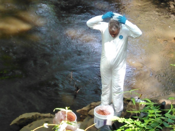
Suiting up, Thomas Greenhalgh
Photo: John S. Quarterman for WWALS, of Thomas Greenhalgh suiting up at the Alapaha Dye Test, 2016-06-22.

Dinah Voyles Pulver, The Daytona-Beach News-Journal, 24 November 2018, State geologist challenging springs action plan raised questions before, Continue reading

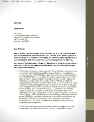
Farmer Randy Dowdy objects to Sabal Trail’s soil mixing evaluation plan 2018-03-13

How can there be soil mixing yet zero noncompliance incidents? FERC saw soil mixing first visit without digging, Dowdy to FERC Randy Dowdy asked directly to FERC, following up his call in AgWeb for an independent investigation of Sabal Trail’s destruction of his world-record-holding soybean fields in Brooks County, Georgia.

Dowdy doesn’t trust Sabal Trail or anybody it sends to investigate that soil mixing. He’s hardly the first to say Sabal Trail’s inspectors don’t; see for example FERC’s Moultrie Scoping Meeting 2015-09-29 where James Bell said pipeline inspectors stood around until they noticed him watching, Sandra Jones said the surveyors were not qualified, and Attorney Daniel Dunn said Sabal Trail operates under darkness of misinformation. Dowdy may be late to the opposition, but he is determined.

Sabal Trail is still a stagecoach line in an electric car world, except stagecoaches didn’t destroy farmers’ fields.

Letter from Randy Dowdy to FERC

Continue reading

Randy Dowdy calls for independent investigation of Sabal Trail soil mixing 2018-03-06

Dear pipeline companies: if you gouge through a rock-star farmer’s world-record-holding soybean fields, you may find he gets national coverage.

Bryan Mitchell, March 6, 2018 08:16 AM, AgWeb powered by Farm Journal, Pipeline Nightmare: Randy Dowdy Calls For Independent Investigation,

Randy Dowdy’s soil death is no mystery, insists the Georgia producer, and now a federal inspection report appears to back his claims of soil damage on record-breaking farmland due to pipeline construction. A letter (Feb. 6) from the Federal Regulatory Commission (FERC) to the Sabal Trail Pipeline Project describes “topsoil and subsoil mixing” on Dowdy’s farming operation, yet significantly does not address issues of noncompliance.

GA-BR-029.000 Dowdy south field, Little Creek, MP 217, 1657-PL-DG-70197-219,, Dowdy parcel 053 00161 Brooks County, GA
GA-BR-029.000 Dowdy south field, Little Creek, MP 217, 1657-PL-DG-70197-219, 30.9439700, -83.6154600

Dowdy signed Continue reading

Fragility of monoculture agriculture in varying water conditions

They don’t want to say “we don’t know,” but they don’t know. At least they have a working hypothesis about the collapse of the 2017 peanut crop in much of Florida: it has to do with variations in rainfall.

Bob Kemerait, Southeast Farm Press, 22 January 2018, Peanut collapse: Something happened but it’s not clear exactly why,

…For months, University of Florida’s Institute of Food and Agricultural Sciences Extension agents led by Anthony Drew, Mace Bauer and Dee Broughton had been sounding the alarm that an unprecedented collapse of the peanut crop was occurring across large areas of Florida’s production region. Symptoms of this collapse included stunted plants, late-season yellowing and leaves with distinctive marginal leaf necrosis. Where most severe, entire fields wilted in the weeks prior to harvest. Abysmal yields, off by as much as 45 percent, forced some to consider their future in farming if solution could not be found.

During the latter third of the season, Continue reading

Crop nitrogen losses into Suwannee Basin

Here is a very interesting paper about increasing nitrogen from crops into the Suwannee River Basin and its springs (promoting algae growth), with actual data on how well best management practices (BMPs) are containing the runoff: Environmental Nitrogen Losses from Commercial Crop Production Systems in the Suwannee River Basin of Florida, by Rishi Prasad, George J. Hochmuth, PLOSOne, Published: December 1, 2016, http://dx.doi.org/10.1371/journal.pone.0167558


Fig 3. Comparison of A) environmental nitrogen losses (Nenvloss) from three crops (potato, sweet corn and silage corn) during four growing seasons (2010 to2013) and B) relationship between seasonal total N rates and environmental nitrogen losses at the study farm in the Middle Suwannee River Basin, Florida. Silage corn was not studied during 2013. Mean values of Nenvloss (represented by individual bars and their standard errors for the three crops) followed by different letters indicate significant difference at α = 0.05 level

Abstract Continue reading

Dust Storm on Lakeland Sands land in Hamilton County, FL

300x225 Dust right up to dirt road, in Dust Storm on Lakeland Sands land in Hamilton County, FL, by John S. Quarterman, for WWALS.net, 25 March 2014 Received yesterday. -jsq

These pictures are of a dust storm that occurred earlier this year. The dust is from Bill Gates’ farms. Look closely, there is a power transmission tower in the picture. Continue reading