Tag Archives: USDA

Farmer Randy Dowdy objects to Sabal Trail’s soil mixing evaluation plan 2018-03-13

How can there be soil mixing yet zero noncompliance incidents? FERC saw soil mixing first visit without digging, Dowdy to FERC 
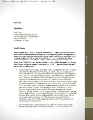
Randy Dowdy asked directly to FERC, following up his call in AgWeb for an independent investigation of Sabal Trail’s
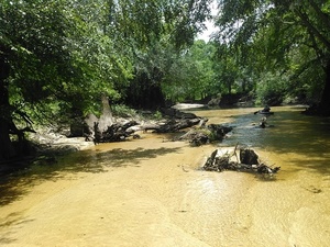
 destruction of his world-record-holding soybean fields in Brooks County, Georgia.

Dowdy doesn’t trust Sabal Trail or anybody it sends to investigate that soil mixing. He’s hardly the first to say Sabal Trail’s inspectors don’t; see for example FERC’s Moultrie Scoping Meeting 2015-09-29 where James Bell said pipeline inspectors stood around until they noticed him watching, Sandra Jones said the surveyors were not qualified, and Attorney Daniel Dunn said Sabal Trail operates under darkness of misinformation. Dowdy may be late to the opposition, but he is determined.

Sabal Trail is still a stagecoach line in an electric car world, except stagecoaches didn’t destroy farmers’ fields.

Letter from Randy Dowdy to FERC

Continue reading

WWALS receives grant for water conservation outreach to farmers and community

FOR IMMEDIATE RELEASE

WWALS receives grant for water conservation outreach to farmers and community (PDF)

Hahira, Georgia; December 27, 2016 — Local water conservation group WWALS Watershed Coalition (WWALS) has received a grant of Just enough water here, 31.0016918, -83.4573364 $6,000 from the Georgia Water Coalition (GWC) to help groups in towns, counties, and countryside to draw the big picture of watershed conservation, as well as to help organize at least one grant from a different source to assist at least one farmer in erosion control.

The award contract of November 11, 2016, says Continue reading

WWALS Watersheds google map

Update 2020-01-25: Superseded by WWALS Suwannee River Basin Map and All Landings in the Suwannee River Basin, now that Suwannee Riverkeeper territory includes the entire Basin plus Estuary, since Waterkeeper Alliance agreed to add the Ichetucknee and Santa Fe Rivers on September 26, 2019.

Update 2017-10-30: River flowlines.
Update 2017-10-08: Better colors plus a Suwannee River Basin map.
Update 2017-04-13: Since December 2016 WWALS Watersheds have included the Lower Suwannee River HUC 03110205 and the Suwannee River Estuary, approved by Waterkeeper Alliance the same time as the license for Suwannee RIVERKEEPER®.

Small, WWALS Watersheds Map Legend

Click on this link for an interactive google map of WWALS watersheds.

The images you see here are static screenshots of that google map. Follow the link above for the actual google map.

The watershed outlines are from Continue reading

Piscola Creek

300x388 Piscola Creek Watersheds, in Piscola Creek, by John S. Quarterman, for WWALS.net, 2013 Running through Thomas and Brooks Counties, Georgia to the Withlacoochee River, Piscola Creek is on the USDA National Resources Conservation Service (NRCS) National Water Quality Initiative (NWQI) as two of the three Georgia Priority Watersheds, all of which are in WWALS watersheds.

Upper Piscola Creek Watershed encompasses 25,936 acres of land in the southeast part of Thomas and western part of Brooks Counties in southwest Georgia. The land around the watershed is about 75 percent photo by Georgia NRCS crop, pasture, range and other associated agriculture use. About 20 percent of the watershed is forested. The other five percent is commercial or communities.

Middle Piscola Creek Watershed encompasses Continue reading