Tag Archives: Cypress Creek

Permit application deficiencies; water modeling, monitoring, and management, mercury, spills, slimes, Florida –WWALS to GA-EPD, TPM TiO2 mining 2024-04-09

Here are the WWALS comments sent to GA-EPD yesterday against the proposed titanium dioxide mine too near the Okefenokee Swamp.

Thanks to all who also sent comments to the Georgia Environmental Protection Division (GA-EPD) during the 60-day comment period.

[Application deficiencies in TPM TiO2 mining permits: Modeling, mercury, spills, slimes, Florida --WWALS to GA-EPD 2024-04-09]
Application deficiencies in TPM TiO2 mining permits: Modeling, mercury, spills, slimes, Florida –WWALS to GA-EPD 2024-04-09

Next, we wait for GA-EPD to read all the comments. Supposedly they have to reply to all questions in those comments.

Most likely then GA-EPD will issue the actual permits. Then lawsuits start flying.

If I am not mistaken, you can still send comments to TwinPines.Comment@dnr.ga.gov. They won’t be considered part of the 60-day comment period, but they will go into the public record, retrievable via an open records request, and usable in lawsuits.

The WWALS Comment

See also PDF. Continue reading

Okefenokee poll and U.S. Interior Secretary Deb Haaland 2022-09-16

Update 2022-12-08: Unacceptable risk to mine near the Okefenokee Swamp –U.S. Interior Secretary Haaland 2022-12-07.

Update 2022-10-06: GA-DNR Board does not discuss mining near Okefenokee Swamp 2022-09-27.

Last Friday Interior Secretary Deb Haaland toured to Okefenokee Swamp, along with Georgia U.S. Senator Jon Ossoff.

[Deb Haaland at ONWR]
Deb Haaland at ONWR

I was there Continue reading

Georgia National Hunting and Fishing Day at Paradise PFA 2022-09-24

This is not a WWALS event, but it sounds fun and we support it. Of the many specific events by GA-DNR Wildlife Resources Division, one is at Paradise Public Fishing Area in our Withlacoochee and Little River Water Trail. That’s east of Tifton on US 82, near Enigma, in Berrien County, Georgia.

[Logo, Map]
Logo, Map

Since the voters approved it in 2006, Georgia has a right of hunting and fishing, in the state Bill of Rights, up there with freedom of speech:

Georgia Constitution, Article I, Section 1, Paragraph XXVIII, The tradition of fishing and hunting and the taking of fish and wildlife shall be preserved for the people and shall be managed by law and regulation for the public good.

Now we can add a Right to Clean Water so fish and wildlife (and people) will have a healthy environment in which to live.


NATIONAL HUNTING AND FISHING DAY IN GEORGIA
SATURDAY, SEPTEMBER 24, 2022
Continue reading

Okefenokee Swamp south drains west to Suwannee River

Update 2022-12-21: Okefenokee Swamp watershed boundaries 2015-08-01.

Most of the south end of the Okefenokee Swamp drains west into the Suwannee River.

This is one reason Suwannee Riverkeeper is so interested in stopping titanium strip mine proposed far too near the southeast corner of the Swamp by Twin Pines Minerals LLC of Alabama.

Please send your comments to Georgia officials asking them to thoroughly review and then reject the five permit applications from the miners:
https://waterkeeper.org/news/help-suwannee-riverkeeper-save-okefenokee-swamp/

[WWALS map: All Landings in the Suwannee River Basin]
WWALS map: All Landings in the Suwannee River Basin

Highlighted on the left is the Little Swannee Creek Confluence with the Suwannee River, several miles downstream from Fargo. That creek connects with Breakfast Branch, which comes down out of the Swamp before crossing FL 2 (GA 94). Orange waterways are in the Suwannee River Basin, and red ones are in the St. Marys River Basin, according to USGS, but see below.

Next to the north is Cypress Creek, which has tributaries way out in the Swamp, and flows pretty much straight west, reaching the Suwannee River a couple of miles downstream of Fargo.

Upstream from Fargo, almost halfway to Griffis Fish Camp, is a creek for which USGS has no name. I’m calling it Strange Island Creek, because it comes west out of the Swamp past North Strange Island and Middle Strange Island. It has branches coming south down from Jack Island. Those islands show up Continue reading

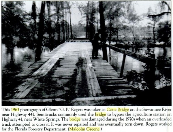
Old wooden Cone Bridge over the Suwannee River, takeout for WWALS outing 2015-11-22

We’ll float down the Suwannee River to this spot Sunday afternoon: come join us!

Old Cone Bridge, 1963, Suwannee River
Picture from Hamilton County, by Marsanne Petty, on page 12; found by Chris Mericle.

Continue reading

Suwannee River from CR 6 to Cone Bridge, WWALS Outing 2015-11-22

Convenient to Lake City, Live Oak, and Jasper, not to mention Fargo, Statenville, Lakeland, and Valdosta, it’s a half-day paddle down the iconic Suwannee River in the cool of November.

CR 6 to Cone Bridge Boat Ramp When: 9AM Sunday November 22nd 2015 Continue reading