Tag Archives: flooding

Valdosta wastewater and flood prevention public meeting by WWALS 2016-10-27

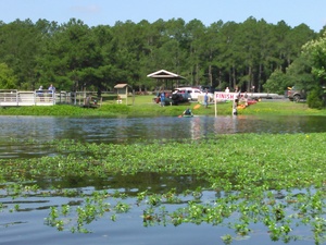
New WWTP, 30.8327808, -83.3283234 Update 2016-10-23: Seen from the air.

Update 2016-10-19: PDF flyer.

Come hear about the $60 million in wastewater fixes Valdosta just finished, what remains to be done, and what they’re doing about flood prevention for the entire Suwannee River Basin in Georgia and Florida. You can ask questions in this first of a new WWALS Quarterly Speaker Series, and the people organizing this work will be there to answer:

  • Henry Hicks, Utilities Director, about wastewater
  • Emily Davenport, Assistant Director of Engineering, about flooding, and
  • Tim Carroll, Valdosta City Council, about solar power for utilities.

When: 6PM Thursday October 27th

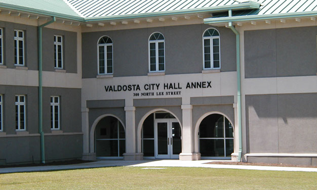
Where: Valdosta City Hall Annex
Multipurpose Room
300 N Lee St.
Valdosta, GA 31601 Continue reading

Road Closures in 2009 Flood, Lowndes County, GA

Back in 2009, Lowndes County spent hundreds of times more in infrastructure repairs than the $40,000 that Valdosta is asking as a match to build an online flood warning map, beyond just fixing sewer system spills to dealing with the rest of the flooding problem. Map of roads closed At recent meetings, some County Commissioners seemed reluctant to authorize the request because the proposed map mostly covers subdivisions in Valdosta. But the entire county was affected by road closures in 2009, so maybe Commissioners could ask to expand the map to cover the whole county, which could also help find sources of the flooding problem. Sources and effects extend all the way to the edges of the county, as you can see in this a google map I built back then:

Roads closed in Lowndes County, Georgia, as of 9:38 a.m April 6th, according to the Valdosta Daily Times. This map shows locations and terrain. It’s a Google map, so it’s interactive: you can zoom and pan and change to satellite view, street map, street view, etc. Some of the locations are guesstimates from the cryptic descriptions in the VDT article. The one green blob is the one reopening mentioned in the article: “North Valdosta Road Withlacoochee River Bridge opened at 10 p.m. Sunday.”

That VDT article no longer seems to be online, but this one is. Jason Schaefer, VDT, 27 April 2013, What natural events cost Lowndes taxpayers, Continue reading

Typical USGS streamgage costs with example near Okapilco Creek

Update 2021-03-09: The funding cost per gauge has gone up, to $22,500, of which usually the USGS contributes about $900.

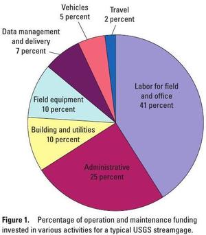
How much would it cost to fund the Okapilco Creek gage so it won’t go offline July 31st? 300x342 Pie: Percentages of funding in various activities, in Streamgage Operation and Maintenance Cost Evaluation, by U.S. Geological Survey, for WWALS.net, 1 June 2010 About $13,600/year, more or less, mostly for field and office labor and administration, with only 10% for the field equipment. Since this gage is located in Brooks County, Georgia, the most likely funding body (after USGS itself) would be the Brooks County Commission. Yes, it’s in WWALS watersheds; no, WWALS doesn’t plan to take on funding streamgages. If some funding organization appeared that wanted to pass the funds through WWALS, which is a 501(c)(3) educational institution, that would be possible. But this seems more like a government issue.

Costs

Continue reading

WWALS Goals for 2015

Boating on our rivers and water trails for them, issues and education: you can help with the fun and work of WWALS! Here’s much of what can be done laid out in a list of a dozen WWALS Goals for 2015. The board has at least one opening right now, and the committees always could use more members. You can apply through the online form.

See also the monthly newsletter, the news about WWALS, and of course the website with blog, facebook the page and group, and WWALS on twitter, Youtube, and the membership google group. You can become a member or corporate sponsor of WWALS online right now.

The WWALS Executive Committee 11 March 2015 recommended Continue reading

Valdosta spilled into Alapaha as well as Withlacoochee watersheds in February

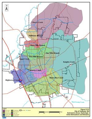
Spilling sewage into the Withlacoochee River apparently wasn’t enough 300x388 Figure 2.2.5. Sub-basins Areas, in Section 2 Methodology, by City of Valdosta, for WWALS.net, 14 January 2011 for Valdosta: in February it also spilled three times into the Alapaha River watershed. At least once this was due to rains directly on Valdosta, for which the levee proposed by the Army Corps of Engineers on Sugar Creek at the Withlacoochee River wouldn’t help. It’s time for Valdosta to move along with fixing its wastewater problems. More transparency from Valdosta would also help. And I, for one, would like to see that promised Corps flooding study of the entire Suwannee River Basin.

In three different reports in February, Valdosta mentioned sewage overflows into either Knights Creek or Dukes Bay Canal, without mentioning that those flow into Mud Swamp Creek, which joins with Grand Bay Creek to form the Alapahoochee River, which joins the Alapaha River, which flows into the Suwannee River. The Florida Department of Health apparently didn’t know that, since it didn’t mention the Alapaha River in its advisories for counties downstream. But Valdosta should know, according to its own SWMP Update Phase 1 Final Report, Section 2 Methodology, 2011-01-14, that about half of Valdosta is drained by Knights Creek and Dukes Bay Canal: Continue reading

WWALS Goals for 2014

A surprising number of the Board’s nine goals for 2014 have been accomplished, and some new ones have already been added. What goals should WWALS have for 2015?

Goals accomplished include becoming an IRS 501(c)(3) and raising money for and purchasing insurance. Some we’ve been doing right along: cleanups, including Rivers Alive. Some are so much the core of what WWALS does that we didn’t even list them as goals, but we’ve been doing them anyway: monthly outings and indoor events.

The later-added goal of the Alapaha River Water Trail is Continue reading

Water issues with VA-2014-07 at Baytree and Azalea Drive in Valdosta –WWALS to Valdosta City Council

Gretchen sent this letter to the Valdosta City Council last Thursday, and is going to read it to them tonight at their Regular Session (PDF. -jsq

Dear Valdosta City Council Members,

300x389 Letter, in Rezoning Water Issues in Valdosta, by WWALS, for WWALS.net, 8 September 2014 WWALS Watershed Coalition, Inc. would like to draw your attention to some issues related to rezoning VA-2014-07 Brooks Turner LLC at the corner of Baytree and Azalea Drive. As you are aware, flooding in Sugar Creek has been a problem for many years. The proposed development of lots between Baytree and Pinetree will result in the removal of approximately seventy (70) mature pine trees, increase paving percentage (the lots are mostly grass with clearly less than 50% covered by rooftops and hard paved surfaces), and most dramatically replace Continue reading

Study before Levee –Tim Carroll

Comment on facebook 10 May 2014 and he told me the same by telephone.

It is clear a full watershed wide study must be completed before any decisions can be made. As established in this first study—The City of Valdosta is the recipient-not the origin- of the flood waters. While it confirms what we already knew, my job is to try and keep the ball rolling forward. Engage congressional leaders, secure funding and find long term, sustainable solutions that benefit all communities within the watershed basin. A levee by itself is not the answer.
–Tim Carroll

This was a comment on Videos: Flooding study by Army Corps of Engineers @ VCC 2014-05-06, which was about the initial study that was confined to Valdosta, and in which the Corps proposed a levee at the mouth of Sugar Creek, above the Withlacoochee River. To their credit, the Corps were clear that they also want a long-term watershed-wide study (they want to do the entire Suwannee River drainage area), and one of the main conclusions of the initial study was:

This report established that there could be Federal interest in pursuing future flood management risk studies undre other USACE authorities.

-jsq

Flooding charts: Withlacoochee and Little Rivers

Related to the Withlacoochee and Little River Water Trail and the double USACE flooding study presentation tonight in Valdosta, here are river level charts upstream and down on the Little River, Okapilco Creek, and the Withlacoochee River related to a new USGS flood-tracking chart. In the example charts on the right, you can see the Little River peaked days ago at Tifton and yesterday at Hahira.

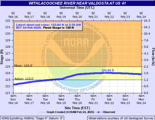
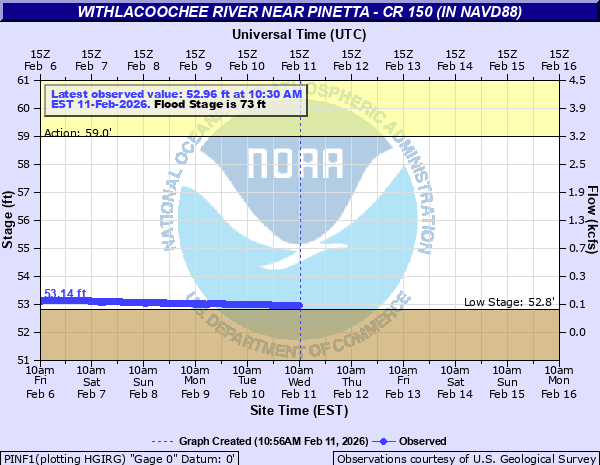
The Withlacoochee River peaked yesterday at US 41. while downstream it’s going up at US 84, and barely starting up at Pinetta (click on the above chart example for the rest). Right now you can see all that in the charts below. If this works, you’ll see something different later, because you’ll see current charts whenever you refresh this page.

Update 2016-05-31: See sea level gage reports.

Update 2016-04-27: graphs from water.weather.gov and some WRWT Safe Water Levels.

Update 2014-11-04: Simplified gage formatting.

Update 2014-11-03: That works, and see also Alapaha River water levels.


Tifton Gauge, Little River at Upper Ty Ty Road, near Tifton, GA, Tift County, GA (02317797)

Highest safe 3.9 feet, 271 NAVD. Lowest boatable 0.1 feet, 267.2 NAVD.

Adel Gauge, Little River near Adel, GA, Cook County, GA (02318000)

Highest safe 7.9 feet, 181 NAVD. Lowest boatable 2.2 feet, 175.3 NAVD.

Hahira Gauge, Little River at GA 122, near Hahira, GA, Lowndes County, GA (02318380)

Highest safe 11 feet, 144 NAVD. Lowest boatable 4.25 feet, 137 NAVD.

Skipper Bridge Gauge, Withlacoochee River at Skipper Bridge Road, near Bemiss, GA, Lowndes County, GA (023177483)

Highest safe 10.7 feet, 131 NAVD. Lowest boatable 2.3 feet, 122.6 NAVD.

Valdosta Gauge, Withlacoochee River at US 41 near Valdosta, GA, Lowndes County, GA (02317755)

Highest safe 12.7 feet, 123′ NAVD. Lowest boatable 5.7 feet, 116′ NAVD.
Okapilco Creek Gauge, Okapilco Creek at GA 333, near Quitman, GA, Brooks County, GA (02318700)


Quitman Gauge, Withlacoochee River at US 84, near Quitman, GA, Brooks County, GA (02318500)

Highest safe 10.5 feet, 94 NAVD. Lowest boatable 2.0 feet, 85.5 NAVD.

Pinetta Gauge, Withlacoochee River near Pinetta, FL., Madison County, FL (02319000)

Highest safe 12.5 feet, 59 NAVD. Lowest boatable 6.0 feet, 52.5 NAVD.
Madison Gauge, Withlacoochee River near Madison, FL , Madison County, FL (02319300)

Highest safe 10.0 feet, 50 NAVD. Lowest boatable 0.1 feet, 40.1 NAVD.
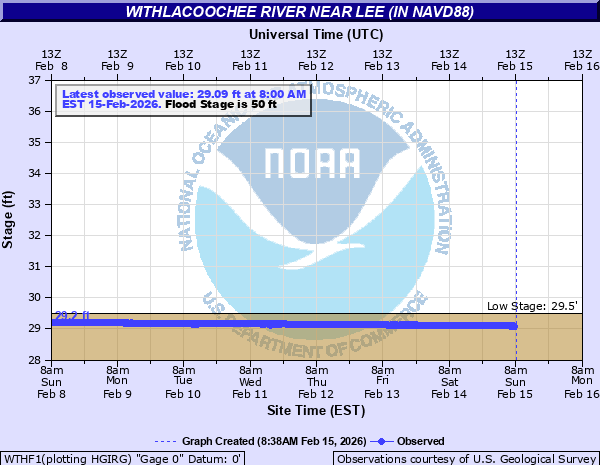
Lee Gauge, Withlacoochee River near Lee, FL, Madison County, FL (02319394)

Highest safe 44.0 feet, 44 NAVD. Lowest boatable 29.5 feet, 29.5 NAVD.
315x535 WRWT, in Withlacoochee River Water Trail gauges, by John S. Quarterman, for WWALS.net, 8 June 2015

 -jsq, John S. Quarterman, Suwannee RIVERKEEPER®

You can join this fun and work by becoming a WWALS member today!

Flooding study presentations by Army Corps in Valdosta 6 May 2014

Received today. -jsq

Good afternoon Mr. Quarterman,

As requested, the date for the U.S. Army Corps of Engineers (USACE) presentation will be on May 6th to Mayor/Council at the work session which begins at 5:30 pm. The City will also have a meeting with the residents and businesses in the USACE project / study area that same night at 6:30 pm at the City Hall Annex – Multipurpose Room.

Continue reading