
 Filed Friday as FERC accession number 20160708-5096,
http://elibrary.ferc.gov/idmws/file_list.asp?document_id=14476452,
“Two new reasons for a USACE Supplemental Environmental Impact Statement and a halt to Sabal Trail permits; see also accession numbers 20160708-5089 and 20160708-5088, by WWALS Watershed Coalition, Inc. under CP15-17.” (PDF) Continue reading
Filed Friday as FERC accession number 20160708-5096,
http://elibrary.ferc.gov/idmws/file_list.asp?document_id=14476452,
“Two new reasons for a USACE Supplemental Environmental Impact Statement and a halt to Sabal Trail permits; see also accession numbers 20160708-5089 and 20160708-5088, by WWALS Watershed Coalition, Inc. under CP15-17.” (PDF) Continue reading
Tag Archives: GA EPD
CR/T Class 3 Permit Change Meeting Report 2016-06-22
A small but inquisitive group attended the CRT Class 3 Permit Change Public meeting on Wednesday June 22nd at the Public Library on Woodrow Wilson Drive in Valdosta.
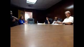 The representatives of the company included Ramesh Mulani (Operations Manager for CR/T), Brian Jones from International Paper (apparently International Paper is responsible for the monitoring of the wells), Carol Northern from EarthCon Consultants, a subcontractor to International Paper and a gentleman whose name I failed to record. Ms. Northern gave a detailed overview of the reasons for the two permit change requests.
- The first permit change was to Continue reading
Request for Class 3 Permit Modification by CR/T from GA-EPD 2016-06-22
Update 2016-06-24: report and video of the meeting.
A chemical plant on E. Hill Ave. in Valdosta wants to stop monitoring chemicals
in one of its wells,
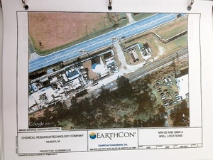 it says because of difficult access due to stormwater that collects there.
Yet they want to “add analysis of naphthalene, 2-methylphenol, and phenol for the post-closure care monitoring program.”
it says because of difficult access due to stormwater that collects there.
Yet they want to “add analysis of naphthalene, 2-methylphenol, and phenol for the post-closure care monitoring program.”
Facebook: event
When: 6-7 PM Wed June 22nd 2016
Where: South Georgia Regional Library
300 Woodrow Wilson Dr, Valdosta, Georgia 31602
This is the same location as the Arizona Chemical plant that almost closed in 2008. Stuart Taylor, VDT, 30 November 2014, Made in Valdosta: Chemical Research Technology, Continue reading
Joint Regional Water Planning Council Meeting, Dublin, GA 2016-06-23
Apparently we get dragged into a meeting of all regional councils with waters flowing into the Atlantic
 because the Suwannee-Satilla RWPC includes much of the Satilla and
St Marys Rivers, even though most of the SSRWPC territory is in our Upper Suwannee watershed.
A tiny bit of our Little River Watershed is in Wilcox County,
which is in the Altamaha RWPC.
because the Suwannee-Satilla RWPC includes much of the Satilla and
St Marys Rivers, even though most of the SSRWPC territory is in our Upper Suwannee watershed.
A tiny bit of our Little River Watershed is in Wilcox County,
which is in the Altamaha RWPC.
Received from GA-DNR May 25th 2016, NOTICE:
JOINT REGIONAL WATER PLANNING COUNCIL MEETING Continue reading
Suwannee-Satilla Regional Water Planning Council meeting, Nashville, GA 2016-03-09
Received today this NOTICE, SUWANNEE-SATILLA REGIONAL WATER PLANNING COUNCIL MEETING, Announcement Date: February 16, 2016, TO ALL INTERESTED PERSONS AND PARTIES::
The Suwannee-Satilla Regional Water Planning Council is holding its next meeting for the Review and Revision of the Suwannee-Satilla Regional Water Plan at the following date, time, and location:
Wednesday, March 9, 2016
Registration: 9:00 A.M. – 9:30 A.M.
Meeting: 9:30 A.M. – 4:00 P.M.Nashville Community Center Continue reading
Reject Sabal Trail easement payment tonight –WWALS to Lowndes County Commission 2016-01-26
The Lowndes County Commission is voting tonight on an easement for the Sabal Trail fracked methane pipeline through a mercury-contaminated closed landfill.
 They only gave one day’s notice, and they didn’t mention the landfill.
Here is the letter (PDF) I just sent them asking them to reject that easement,
to support their own previous unanimous resolution against Sabal Trail,
and to contact state and federal elected and appointed officials and ask them
also to reject Sabal Trail.
You can write them, too, to commissioner@lowndescounty.com.
They only gave one day’s notice, and they didn’t mention the landfill.
Here is the letter (PDF) I just sent them asking them to reject that easement,
to support their own previous unanimous resolution against Sabal Trail,
and to contact state and federal elected and appointed officials and ask them
also to reject Sabal Trail.
You can write them, too, to commissioner@lowndescounty.com.
To: Lowndes County Board of County Commissioners, Continue reading
EPA stepped back, while opposition ramps up against Sabal Trail fracked methane pipeline
FOR IMMEDIATE RELEASE
EPA stepped back, while opposition ramps up against Sabal Trail fracked methane pipeline
Hahira and Albany, Georgia, December 18, 2015— (PDF) Mysteriously contradicting a substantive October letter from U.S. Environmental Protection Agency (EPA) Region 4 in Atlanta, a different EPA branch last Friday sent a brief and sketchy letter to the U.S. Army Corps of Engineers uncritically accepting what Sabal Trail’s attorney’s told it, even as multiple environmental and landowner organizations filed objections with the Corps and multiple state agencies against that invading natural gas pipeline.

Tim Carroll, Valdosta City Council member, said, “I don’t understand how EPA and FERC can say there will not be a negative impact on our environment, aquifer, streams and rivers. A number of experts testified and spoke up saying the likelihood is very high that there could be damage to the aquifer and the environment. Why would we want to allow this to happen, to run the risk of seriously degrading one of the best water resources in the world.,” Valdosta, Moultrie, and Albany, the three biggest cities along the pipeline path in Georgia, all passed resolutions against Sabal Trail, as did the counties of Terrell, Dougherty, Colquitt, Brooks, and Lowndes, in Georgia, and Hamilton and Suwannee Counties in Florida.
“The one government agency actually defending our drinking in the Floridan Aquifer and the many rivers in Georgia and Florida just stifled itself,” Continue reading
Draft TMDL for Suwannee River Basin
Downstream from Valdosta and Tifton on the Withlacoochee River, and downstream from Fitzgerald on the Willacoochee River: room for improvement in fecal coliform,
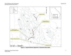 said the Georgia Environmental Protection Division in a draft report issued Friday.
The comment deadline is January 20th, 2016.
On a quick read, the various wastewater treatment plants do not seem to be the main source of the contamination.
Other likely culprits include leaking septic tanks, concentrated livestock operations, and landfills and land application sites, both closed and operating.
Also notice the proposed Sabal Trail fracked methane pipeline would cross most if not all of these TMDL locations in Lowndes County.
Would drilling under the Withlacoochee River and open cuts in these areas help the TMDL problem?
said the Georgia Environmental Protection Division in a draft report issued Friday.
The comment deadline is January 20th, 2016.
On a quick read, the various wastewater treatment plants do not seem to be the main source of the contamination.
Other likely culprits include leaking septic tanks, concentrated livestock operations, and landfills and land application sites, both closed and operating.
Also notice the proposed Sabal Trail fracked methane pipeline would cross most if not all of these TMDL locations in Lowndes County.
Would drilling under the Withlacoochee River and open cuts in these areas help the TMDL problem?
Here’s the NOTICE OF AVAILABILITY OF PROPOSED TOTAL MAXIMUM DAILY LOADS FOR WATERS AND POLLUTANTS OF CONCERN IN THE STATE OF GEORGIA November 20, 2015, which includes: Continue reading
Stop the Sinkhole Trail Pipeline tonight in Albany, GA: Public Hearing, Sabal Trail Compressor Air Quality Permit, GA-EPD 2015-11-05
FERC requires state permits, including an air quality permit from GA-EPD: no permit, no pipeline. You can help stop Spectra Energy’s the Sabal “Sinkhole” Trail pipeline 6:30 PM tonight, 5 November 2015 at Albany Technical College, Kirkland Conference Center, 1704 S. Slappey Boulevard, Albany, GA 31701. There will be a press conference by the opposition about 5:45.
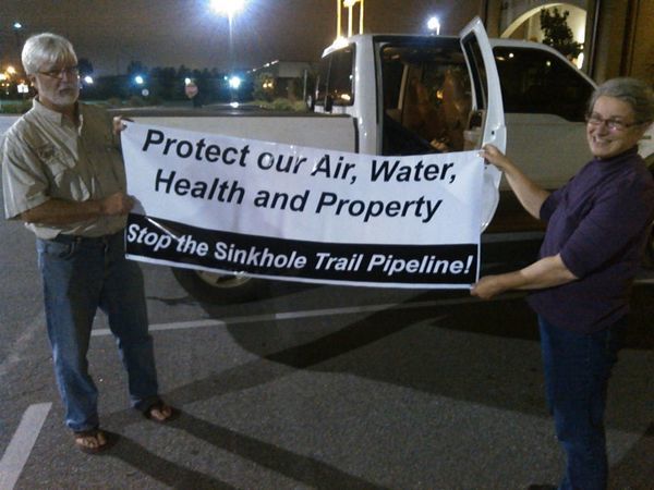
Gretchen Quarterman, WWALS Watershed Coalition and Gordon Rogers, Flint Riverkeeper, last night with the banner he had made for the occasion.
Here are Press release and other details.
You can oppose this unnecessary, destructive, and hazardous pipeline in many other ways, including supporting WWALS opposition to an FDEP permit to drill under the Suwannee River in Florida.
-jsq
You can join this fun and work by becoming a WWALS member today!
Hazardous Site Inventory –GA-EPD
Press Release, 28 August 2015, Public Advisory: Georgia EPD Issues 2015 Hazardous Site Inventory with Interactive Map,
The Hazardous Site Inventory (HSI) is a list of sites in Georgia where there has been a known or suspected release of a regulated substance above a reportable quantity and which have yet to show they meet state clean-up standards. The HSI is published annually by the Georgia Environmental Protection Division. The new interactive Map uses the familiar Google Maps interface and includes basic information about each site as well as links to individual Site Summary pages. More information about the HSI, including the Google Maps feature, is available at: http://epd.georgia.gov/hazardous-site-inventory.
Follow that link and you’ll find an interactive map plus an introduction and lists by name, county, site number, and class.
Not all the hazardous sites shown above are in WWALS territory. For comparison, Continue reading