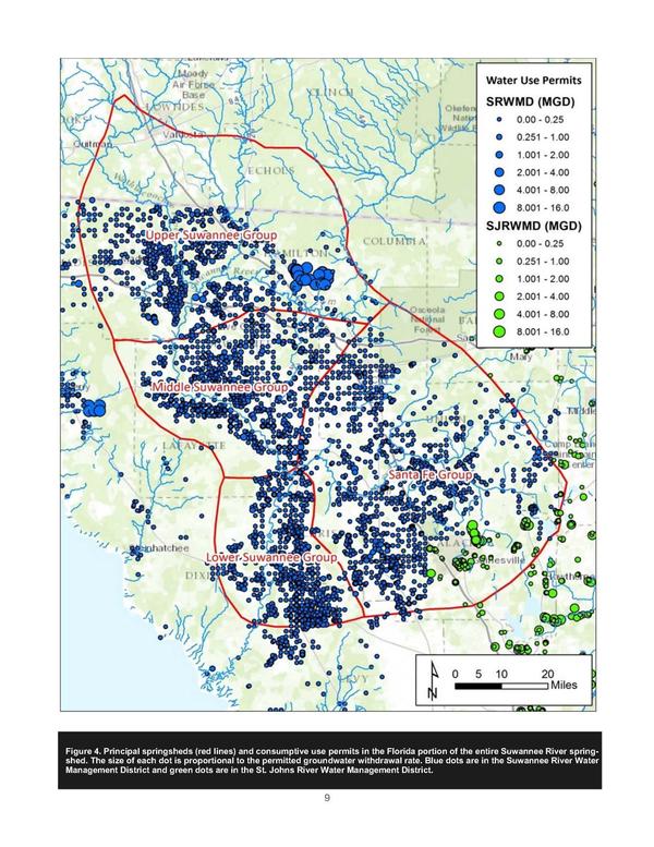
Tag Archives: Quantity

Suwannee-Satilla and GA coastal river water councils in Dublin, GA 2016-11-17

Next month, once again the upper Suwannee that drains into the Gulf gets pulled into a meeting with coastal Georgia Water Planning Councils. This is the meeting that got delayed by hurricane.

GA DNR, Bulletin, 18 October 2016,

Joint Regional Water Planning Council Meeting NEW DATE: November 17, 2016

Georgia Department of Natural Resources sent this bulletin at 10/18/2016 09:18 AM EDT

NOTICE:

JOINT REGIONAL WATER PLANNING COUNCIL MEETING

Announcement Date: October 18, 2016

TO ALL INTERESTED PERSONS AND PARTIES:

A Joint Council Meeting will be held for the Altamaha, Coastal Georgia, Middle Ocmulgee, Savannah-Upper Ogeechee, Suwannee-Satilla and Upper Oconee Regional Water Planning Councils at the following date, time, and location:

Continue reading

Valdosta wastewater and flood prevention public meeting by WWALS 2016-10-27

New WWTP, 30.8327808, -83.3283234 Update 2016-10-23: Seen from the air.

Update 2016-10-19: PDF flyer.

Come hear about the $60 million in wastewater fixes Valdosta just finished, what remains to be done, and what they’re doing about flood prevention for the entire Suwannee River Basin in Georgia and Florida. You can ask questions in this first of a new WWALS Quarterly Speaker Series, and the people organizing this work will be there to answer:

  • Henry Hicks, Utilities Director, about wastewater
  • Emily Davenport, Assistant Director of Engineering, about flooding, and
  • Tim Carroll, Valdosta City Council, about solar power for utilities.

When: 6PM Thursday October 27th

Where: Valdosta City Hall Annex
Multipurpose Room
300 N Lee St.
Valdosta, GA 31601 Continue reading

Suwannee-Satilla and GA coastal river water councils in Dublin, GA 2016-10-06

Update 2016-10-07: Postponed due to Hurricane Matthew. New date not yet known.

Next week, once again the upper Suwannee that drains into the Gulf gets pulled into a meeting with coastal Georgia Water Planning Councils.

GA DNR, Bulletin, 27 September 2016, Statewide Water Plan – Joint Council Meeting #2 Agenda – October 6 / Dublin, GA,

Joint Council Meeting #2 — Eastern Councils
Thursday, October 6, 2016

Dubose Porter Center
Oconee Fall Line Technical College
560 Pinehill Road
Dublin, GA 31021

Agenda Continue reading

Bill Gates, Suwannee Farms, Lakeland Sands, examples from the air 2016-06-21

Here are a few pictures of some Bill Gates properties from the MIDS Southwings flyover of June 21st, 2016, including Lakeland Sands 208th St. to Suwannee Farms 30.0667640, -82.9828050 Suwannee Farms which we previously discovered a Gates subsidiary had bought.

Notice how close these lands are to the Suwannee River or the Withlacoochee River and Madison Blue Spring. Some of them look freshly cleared. Many of them are probably also in Floridan Aquifer recharge zones. There is more identification work to be done. And we have more aerial pictures (and video).

See also the WWALS web page on Corporate Agriculture.

You can join this fun and work by becoming a WWALS member today!

Continue reading

Federal permits inflame opposition to Sabal Trail fracked methane pipeline boondoggle WWALS PR 2016-08-16

PDF FOR IMMEDIATE RELEASE

Hahira, Georgia, August 16th 2016 — There is no excuse for $3 billion down this rathole of a 20th century dying fossil fuel industry now that there are more solar power jobs than in all of oil and gas extraction. One federal permit Friday and another federal go-ahead impending for the Sabal Trail invasion of private property and wetlands in Georgia, Florida, and Alabama stiffens the resolve of the rapidly expanding opposition. WWALS Watershed Coalition (WWALS) has revealed apparent wetlands violations and federal rule violations by Spectra Energy, the Houston, Texas pipeline company that wants to gouge under our Withlacoochee and Suwannee Rivers, risking our water supply for its profit. Sierra Club has vowed to use “all legal means necessary to stop this fracked gas pipeline.” Opposition across Georgia continues as dozens of new groups joined the fight a week ago in Gainesville, Florida. News Friday of a U.S. Army Corps of Engineers (USACE) wetlands permit has inflamed opposition across the country to this latest fossil fuel land and water grab.

Last month WWALS reported to USACE and to the Federal Energy Regulatory Commission (FERC) that Sabal Trail already has Continue reading

Road Closures in 2009 Flood, Lowndes County, GA

Back in 2009, Lowndes County spent hundreds of times more in infrastructure repairs than the $40,000 that Valdosta is asking as a match to build an online flood warning map, beyond just fixing sewer system spills to dealing with the rest of the flooding problem. Map of roads closed At recent meetings, some County Commissioners seemed reluctant to authorize the request because the proposed map mostly covers subdivisions in Valdosta. But the entire county was affected by road closures in 2009, so maybe Commissioners could ask to expand the map to cover the whole county, which could also help find sources of the flooding problem. Sources and effects extend all the way to the edges of the county, as you can see in this a google map I built back then:

Roads closed in Lowndes County, Georgia, as of 9:38 a.m April 6th, according to the Valdosta Daily Times. This map shows locations and terrain. It’s a Google map, so it’s interactive: you can zoom and pan and change to satellite view, street map, street view, etc. Some of the locations are guesstimates from the cryptic descriptions in the VDT article. The one green blob is the one reopening mentioned in the article: “North Valdosta Road Withlacoochee River Bridge opened at 10 p.m. Sunday.”

That VDT article no longer seems to be online, but this one is. Jason Schaefer, VDT, 27 April 2013, What natural events cost Lowndes taxpayers, Continue reading

Lowndes County to match Valdosta funding for LiDAR flood mapping? 2016-07-11

Valdosta already had an airplane fly over Lowndes County and collect Light Detection and Ranging (LiDAR) data for flood mapping. Will Lowndes County step up and match Valdosta on this project that affects everybody in the county (and downstream into Florida)? Valdosta started this LiDAR project in March 2015, and Valdosta fronted the entire cost to get it done, we know because Valdosta Assistant Director of Utilities Emily Davenport and Valdosta City Council Tim Carroll told us at a meeting Valdosta held at the request of WWALS for interested parties downstream in Florida and from as far away as Atlanta.

On the agenda for the 8:30 AM Monday morning Lowndes County Commission Work Session, item 7.d. Continue reading

Where to look for dye from Alapaha Dye test

Update 2023-05-01: Alapaha Swallets Dye Trace Project 2016-10-01.

Tom Greenhalgh dying the Dead River, Harley Means, and a drone Tom Greenhalgh started putting the dye in the Dead River Swallet about 11:06 this morning, with Harley Means observing in this picture, plus a drone also taking pictures. See below for where to look for the dye coming back up in the next few days. If you see it, please take a water sample for SRWMD. Continue reading

Madison, FL BOCC tonight: WWALS on agenda about Sabal Trail 2016-06-22

Sabal Trail would go far too close to Madison Blue Spring and water wells in Madison County, it doesn’t have all permits, and the Madison BOCC could help stop this unnecessary, destructive, and hazardous fracked methane pipeline boondoggle. I have five minutes to say all that tonight to the Madison Board of County Commissioners.

Madison County, FL Courthouse Annex
Photograph by George Lansing Taylor Jr.

Anybody else who wants to speak, please sign up in advance, according to the Madison BOCC meeting rules. And the more people who come, the more likely they’ll pay attention.

When: 6PM Wednesday June 22nd 2016

Where: Courthouse Annex, 229 S.W. Pinckney Street, Madison, Florida 32340

Excerpt from the agenda. Continue reading

WWALS flies with Southwings

Many thanks to Southwings and pilot Roy Zimmer for the ride on Roy’s Rollercoaster. The wind did pick up a bit towards mid-day but that only made it more fun.

Chris Mericle, John S. Quarterman, Roy Zimmer, Can Denizman
Chris Mericle, John S. Quarterman, Roy Zimmer of Southwings, Can Denizman

We saw what we flew to see. More on that later.

-jsq

You can join this fun and work by becoming a WWALS member today!