Tag Archives: Suwannee River

Atlantic Sunrise: Williams fracking pipeline through Sabal Trail to LNG export in Florida, Georgia, Maryland, and elsewhere

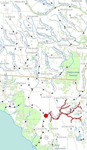
Fracked methane would come from Pennsylvania across our Withlacoochee River twice to LNG export in Florida, and many other rivers and aquifers would have the same problem throughout North America, as would domestic natural gas users as LNG export drives prices up, and local and state taxpayers having to clean up after insufficiently-insured pipeline companies. All the named coastal arrows on this map from Williams’ Atlantic Sunrise project in Pennsylvania branch off from Williams Transco to LNG export operations:

Continue reading

Springs, shoals, and pipeline: Withlacoochee and Suwannee Rivers 21 Sep 2014

Update 5 September 2014: Join us on the rivers even if you’re not yet a member, and many things have happened in the past few weeks: see new post.

Update 25 August 2014: Chris Mericle, our local host for this outing, spoke to the Hamilton County Commission Tuesday 19 August 2014 about what he’s trying to protect from the pipeline.

Paddle past springs, shoals, sinkholes, and where Sabal Trail proposes a fracked methane pipeline to cross the Withlacoochee and Suwannee Rivers in Florida: the WWALS September Outing. Spend five Sunday hours on about ten miles of two of our fabulous southern blackwater rivers.

Meet 10AM Sunday September 21st at the CR 143 Ramp at mile 8 on the Withlacoochee River, 30.449111, -83.221352 or 30° 26′ 56.796″ N 83° 13′ 16.8666″ W. Take out at Anderson Spring, just past I-10, 30° 21′ 10.6806″ N 83° 11′ 21.7314″ S

This event is FREE! All we ask is that you are a current member of WWALS Watershed Coalition. If not, its easy to join online today at /donations/. Continue reading

LNG export proposed from Suwannee and St Johns River Watersheds

A fourth Florida LNG export operation seeks approval, this one explicitly wanting to use methane from the Sabal Trail Transmission fracked methane pipeline. It’s on the divide between our Suwannee River Basin and the St Johns River Basin, where Jaxport is proposing to ship out liquid natural gas from Jacksonville. St Johns Riverkeeper and Our Santa Fe River beware.

The Sabal Trail pipeline itself was already proposed to cross three rivers in the Suwannee Basin: Continue reading

Cross the Suwannee River: Sabal Trail permit application with FL-DEP

After an application for an exemption for the Withlacoochee River and the Santa Fe River, here’s Sabal Trail’s application to drill under the Suwannee River in between. Should we also expect an “HDD CROSSING” permit application for the Withlacoochee and Suwannee Rivers? And watch out, The Villages in Sumter County, Florida! Sabal Trail has applied for a permit in your county, too. Continue reading

Sabal Trail has applied for a Withlacoochee River water permit with Florida DEP

Sabal Trail is asking for permits for its fracked methane pipeline from the Florida Department of Environmental Protection. One of them is for our Withlacoochee River.

ERP is Environmental Resource Permit, and here’s a permit found in ERP Exemption Permit applications, FL DEP Northeast Office: Continue reading

Suwannee Bioregion Coalition?

Related to population centers in the Suwannee River watershed, someone asked, “Do we need an interstate Suwannee Bioregion Coalition to guard the waters that feed into the Suwannee River?” We’ve got pieces of it already cooperating to some extent in opposing the Sabal Trail pipeline. There are many other even larger issues that everyone in the Suwannee River basin faces.

In south Georgia and north Florida we have Continue reading

Our Santa Fe River and Ichetucknee Alliance for water conservation

Much conservation activism lately on the third main tributary of the Suwannee River, the Santa Fe River, with its tributary the Ichetucknee River, both completely in Florida, unlike WWALS’ Withlacoochee and Alapaha Rivers, which cross from Georgia into Florida. They each have their own watershed groups, somewhat like WWALS.

Christopher Curry wrote for the Gainesville Sun 21 June 2014, Grassroots environmentalists fight to protect Ichetucknee, Santa Fe,

At the head spring, a woman stands in knee-deep water on the stairs leading into the swimming hole. About 20 feet in front of her, splashing, swimming family members shout out some encouragement to try to coax her into the cold blue water.

It’s an idyllic scene of summer fun. At a nearby picnic table in the shade, the atmosphere is more serious.

There, some folks from two small but active environmental groups in the Suwannee River Water Management District Our Santa Fe River and the Ichetucknee Alliance — are gathered, sharing Continue reading

Regional Water Council Meeting Wednesday AM in Valdosta

Meeting notice: -jsq

NOTICE:

SUWANNEE-SATILLA
REGIONAL WATER PLANNING COUNCIL MEETING
FOR
REGIONAL ASSESSMENT OF IMPLEMENTATION STATUS

Announcement Date: May 6, 2014

TO ALL INTERESTED PERSONS AND PARTIES:
The Suwannee-Satilla Regional Water Planning Council is holding its next meeting
at the following date, time, and location:
Wednesday, May 21, 2014
Registration: 9:30 A.M. – 10:00 A.M.
Meeting: 10:00 A.M. – 1:00 P.M.


Valdosta City Hall Annex
Multipurpose Room
300 N. Lee Street
Valdosta, GA

For additional information about the Suwannee-Satilla Regional Water Planning
Council please contact:
Cliff Lewis, Assistant Branch Chief – EPD Watershed Protection Branch
229-391-2400 or Cliff.Lewis@dnr.state.ga.us

Pipeline would cross Withlacoochee River twice

The detail maps in the General Project Description in the 15 November 2013 update to FERC by Sabal Trail Transmission reveal that the proposed path would cross the Withlacoochee River both where the river is the border of Brooks and Lowndes County and where it is the border between Hamilton and Madison County near Ellaville. In between, the pipeline would run through many wetlands near the river and through quite a few recharge zones for our drinking water source, the Floridan Aquifer. Then it crosses our downstream river, the Suwannee, into Suwannee County, Florida.

Continue reading

Streamer on the Suwannee, Alapaha, and Withlacoochee Rivers: ten or more rivers and many creeks, lakes, swamps, and ponds

Update 3 March 2016: Suwannee River, ten rivers, and current location of USGS streamer.

The USGS Streamer interactive map shows all (well, most) tributaries of our two biggest WWALS rivers. Visitors sometimes refer to our “four rivers” since we only originally named four in our WWALS mission: Withlacoochee, Willacoochee, Alapaha, and Little. Yet we added the upper Suwannee, and there always were more than that: from one to ten rivers, depending on how you count them.

600x817 WWALS Rivers, in WWALS Rivers, by John S. Quarterman, for WWALS.net, 25 July 2015

The Withlacoochee River tributary map here shows the New River south of Tifton joining the Withlacoochee between Nashville and Adel.

Withlacoochee River Alapaha River

The New River is rather important, since it forms half of the boundary between Cook and Berrien Counties (the Withlacoochee River forms the other half): Continue reading