Tag Archives: USGS

Alapaha River water levels

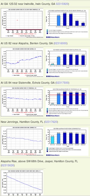
300x655 Example 2014-11-03, in Alapaha River Water Levels, by John S. Quarterman, for WWALS.net, 3 November 2014 Update 2016-12-23: graphs from water.weather.gov.

Update 2016-05-31: See sea level gage reports.

Update 2015-04-28: Added flood stages and tentative highest safe and lowest boatable water levels, both above the charts for each gauge and in a summary table. If you have data, please let us know.

Here are water level gauges for the Alapaha River in Georgia and Florida, north to south. The graphs should show the current levels at this time, in feet, plus for most of the gauges a bar graph of selected historic levels.

This is a draft of a concept for use with the Alapaha River Water Trail. See also Alapaha River Rainy Season.

It is also a companion to the similar set of graphs for the Withlacoochee and Little Rivers.

See below for the current Alapaha River water level graphs. Continue reading

Cook County, GA ground water depletion –USGS

In USGS’s web page on Groundwater depletion:

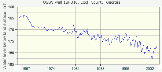
The chart below shows monthly-mean water levels from 1964 to 2003 for a well in Cook County, sourthwest Georgia. The well is used for irrigation and public- supply purposes and offers a good visual representation of long-term groundwat er declines due to excessive pumping. [d]—data for the chart is available.

West-central Florida— Continue reading

USGS warns Withlacoochee River already leaks into Floridan Aquifer

There’s a reason Valdosta’s water wells are 400 feet deep. Its earlier, shallower wells were sucking up Withlacoochee River water that still leaks into groundwater. Should we risk a fracked methane pipeline digging under that same river and possibly causing more sinkholes and underground movement of contaminants, some perhaps coming from the pipeline itself or its demands for pressure testing water?

Sustainability of Ground-water Resources, by William M. Alley Thomas E. Reilly O. Lehn Franke, 1 January 1999, U.S. Department of the Interior, U.S. Geological Survey – Publisher. In Box E on Page 63:

The Connection Between Surface-Water Quality and Ground-Water Quality in a Karst Aquifer


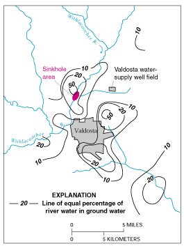
Figure E-1. Estimated percentage of Withlacoochee River water in ground water in the Upper Floridan aquifer, June 1991. (Modified from Plummer and others, 1998.)
The Upper Floridan aquifer, which is the sole source of water supply for Valdosta, Georgia, and much of the surrounding area, receives large volumes of direct discharge from the Withlacoochee River through sinkholes in the streambed or off-channel. A highly interconnected conduit system has developed Continue reading

Flooding charts: Withlacoochee and Little Rivers

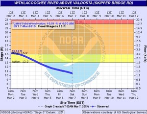
Related to the Withlacoochee and Little River Water Trail and the double USACE flooding study presentation tonight in Valdosta, here are river level charts upstream and down on the Little River, Okapilco Creek, and the Withlacoochee River related to a new USGS flood-tracking chart. In the example charts on the right, you can see the Little River peaked days ago at Tifton and yesterday at Hahira.

The Withlacoochee River peaked yesterday at US 41. while downstream it’s going up at US 84, and barely starting up at Pinetta (click on the above chart example for the rest). Right now you can see all that in the charts below. If this works, you’ll see something different later, because you’ll see current charts whenever you refresh this page.

Update 2016-05-31: See sea level gage reports.

Update 2016-04-27: graphs from water.weather.gov and some WRWT Safe Water Levels.

Update 2014-11-04: Simplified gage formatting.

Update 2014-11-03: That works, and see also Alapaha River water levels.


Tifton Gauge, Little River at Upper Ty Ty Road, near Tifton, GA, Tift County, GA (02317797)

Highest safe 3.9 feet, 271 NAVD. Lowest boatable 0.1 feet, 267.2 NAVD.

Adel Gauge, Little River near Adel, GA, Cook County, GA (02318000)

Highest safe 7.9 feet, 181 NAVD. Lowest boatable 2.2 feet, 175.3 NAVD.

Hahira Gauge, Little River at GA 122, near Hahira, GA, Lowndes County, GA (02318380)

Highest safe 11 feet, 144 NAVD. Lowest boatable 4.25 feet, 137 NAVD.

Skipper Bridge Gauge, Withlacoochee River at Skipper Bridge Road, near Bemiss, GA, Lowndes County, GA (023177483)

Highest safe 10.7 feet, 131 NAVD. Lowest boatable 2.3 feet, 122.6 NAVD.

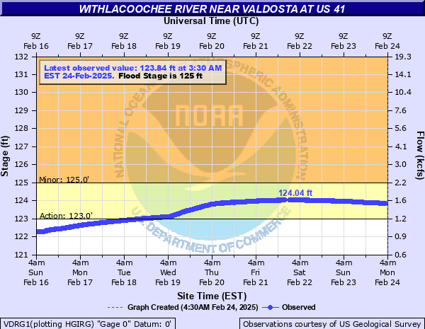
Valdosta Gauge, Withlacoochee River at US 41 near Valdosta, GA, Lowndes County, GA (02317755)

Highest safe 12.7 feet, 123′ NAVD. Lowest boatable 5.7 feet, 116′ NAVD.
Okapilco Creek Gauge, Okapilco Creek at GA 333, near Quitman, GA, Brooks County, GA (02318700)


Quitman Gauge, Withlacoochee River at US 84, near Quitman, GA, Brooks County, GA (02318500)

Highest safe 10.5 feet, 94 NAVD. Lowest boatable 2.0 feet, 85.5 NAVD.

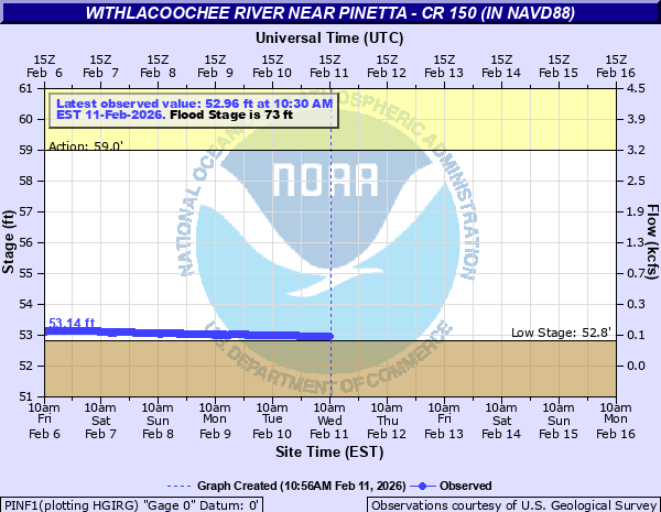
Pinetta Gauge, Withlacoochee River near Pinetta, FL., Madison County, FL (02319000)

Highest safe 12.5 feet, 59 NAVD. Lowest boatable 6.0 feet, 52.5 NAVD.
Madison Gauge, Withlacoochee River near Madison, FL , Madison County, FL (02319300)

Highest safe 10.0 feet, 50 NAVD. Lowest boatable 0.1 feet, 40.1 NAVD.
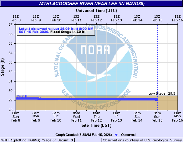
Lee Gauge, Withlacoochee River near Lee, FL, Madison County, FL (02319394)

Highest safe 44.0 feet, 44 NAVD. Lowest boatable 29.5 feet, 29.5 NAVD.
315x535 WRWT, in Withlacoochee River Water Trail gauges, by John S. Quarterman, for WWALS.net, 8 June 2015

 -jsq, John S. Quarterman, Suwannee RIVERKEEPER®

You can join this fun and work by becoming a WWALS member today!

Streamer on the Suwannee, Alapaha, and Withlacoochee Rivers: ten or more rivers and many creeks, lakes, swamps, and ponds

Update 3 March 2016: Suwannee River, ten rivers, and current location of USGS streamer.

The USGS Streamer interactive map shows all (well, most) tributaries of our two biggest WWALS rivers. Visitors sometimes refer to our “four rivers” since we only originally named four in our WWALS mission: Withlacoochee, Willacoochee, Alapaha, and Little. Yet we added the upper Suwannee, and there always were more than that: from one to ten rivers, depending on how you count them.

600x817 WWALS Rivers, in WWALS Rivers, by John S. Quarterman, for WWALS.net, 25 July 2015

The Withlacoochee River tributary map here shows the New River south of Tifton joining the Withlacoochee between Nashville and Adel.

Withlacoochee River Alapaha River

The New River is rather important, since it forms half of the boundary between Cook and Berrien Counties (the Withlacoochee River forms the other half): Continue reading

Watershed meeting organized by Army Corps of Engineers

The U.S. Army Corps of Engineers (USACE) didn’t know there was a large water problem hereabouts, but now they do, and they want to take a watershed-wide approach, from the headwaters to the Gulf of Mexico, including both surface water and aquifer issues, perhaps starting with redrawing FEMA’s flood maps, and maybe even including once again funding the state water council.

Thursday 11 April 2013 there was a rather large governmental meeting organized by USACE in response to the City of Valdosta’s request of 11 March 2103. Yesterday, Valdosta City Council District 5 Tim Carroll sent the appended list of attendees, augmented by a conversation with him on the phone just now. We know little else, because no media or private citizens were invited.

  • USACE Savannah office: Jeff Morris, Georgia Silver Jackets Coordinator and Beth Williams, Hydraulic Engineer
  • USACE Jacksonville office: David Apple, Chief, Watershed and Restoration Planning Section
  • GADNR: Christopher Hill and Tom Shillock, GAEPD Floodplain Management Unit
  • GEMA: Dee Langley, Planning Program Manager and Terry Lunn, Director, Hazard Mitigation Division
  • GEMA: Gary Rice – Regional Field Coordinator
  • USGS: Brian McCallum, Supv. Hydrologist/ADir and Keith McFadden, Physical Scientist
  • FEMA Region 4: Susan Wilson, CFM, Floodplain Management and Insurance Branch Chief and Janice Mitchell, Insurance Specialist and Lender Compliance

Those state and national agencies were brought by:

Continue reading