Category Archives: Blueway

Updates from Trails Committee Meeting 2018-08-19

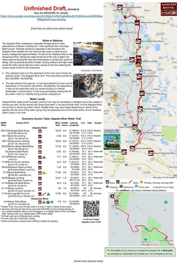
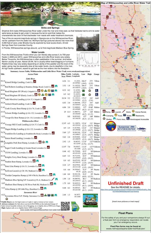
Here’s an update on the draft brochures for both WWALS Water Trails, after the recent meeting of the WWALS Water Trails Committee. We could still use more pictures.

Please email pictures to wwalswatershed@gmail.com. Please say who took each picture, when, where, and of what. High resolution, please.

ARWT Mapside, ARWT

If you want to join the WWALS Trails Committee to help continue organizing this work, actually editing the documents shown below, you must be a WWALS member and apply.

What

The Trails Committee is working on brochures for Continue reading

Alapaha Quest, TBA on Alapaha River, 2018-10-06

Update 2018-10-03: Due to low water in the Alapaha River, this outing is cancelled. Also, this is the same weekend as the Hahira Honeybee Festival, which takes a lot of WWALS resources; please come join us there.

Plus we’re doing a Cleanup at Troupville Boat Ramp on the Little River, Saturday, October 13, and the WWALS Boomerang on the Withlacoochee River from Langdale Park down to Sugar Creek and back, Saturday, November 3, and a paddle in the Okefenokee Swamp Saturday, December 8, 2018. Plus numerous festivals.

Next year the BIG Little River Paddle Race will be Saturday, April 27, 2019 at Reed Bingham State Park, and Paddle Georgia is starting at Troupville Boat Ramp for five days down the Withlaoochee and Suwannee Rivers in June 2019.

For more WWALS outings and events as they are posted, see the WWALS calendar or the WWALS outings and events web page. WWALS members also get an upcoming list in the Tannin Times newsletter.

 -jsq, John S. Quarterman, Suwannee RIVERKEEPER®

You can join this fun and work by becoming a WWALS member today!

Experience the wilderness of the Alapaha River Water Trail as we continue the Alapaha Quest. Location for this outing will be determined dependent on water levels.

When: 8 AM, Saturday, October 6, 2018

Put In: To be announced (TBA).

Take Out: TBA

Bring: the usual personal flotation device, boat paddles, food, drinking water, warm clothes, and first aid kit. Also trash pickers and trash bags: every WWALS outing is also a cleanup.

Free: This outing is free to WWALS members, and $10 (ten dollars) for non-members. We recommend you support the work of WWALS by becoming a WWALS member today!

Event: facebook, meetup

Movie: Birds singing (3.4M),
Birds were singing, 2017-02-11.

Continue reading

Brochures: Trails Committee Meeting 2018-08-19

After only four years, we’re almost finished with both WWALS Water Trails! You can help get them done.

The new Chair of the WWALS Trails Committee, Dan Phillips, has called a meeting to work on one of the final steps: designing printed brochures. Anyone can attend, and anyone can send in pictures or suggestions.

Please email pictures to wwalswatershed@gmail.com. Please say who took each picture, when, where, and of what. High resolution, please.

When: 2:30-5PM, Sunday, 19 August 2018

Where: Community Hall 2,
South Georgia Regional Library,
2906 Julia Dr, Valdosta, GA 31602

By phone: Dial-in Number: (641) 715-3580
Meeting ID: 855-676

Event: facebook, meetup

WLRWT Mapside, WLRWT

If you want to join the WWALS Trails Committee to help continue organizing this work, actually editing the documents shown below, you must be Continue reading

Alapaha Quest, Rowetown to Willacoochee, Alapaha River, 2018-08-11

Bring a rope in case we need to drag the boats across deadfalls, and expect low-hanging branches, as we experience the wilderness from Rowetown Church Landing to Willacoochee Landing, on the Alapaha River Water Trail, continuing Alapaha Quest.

When: 8 AM, Saturday, August 11, 2018

Put In: Rowetown Church Landing, 1291 Rowetown Church Road, Alapaha, GA 31622, River bank on private road back of cemetery, we have permission.

Take Out: Willacoochee Landing, GA 135, Atkinson County side, 2.8 miles south of Willacoochee, GA, Atkinson County.

Bring: the usual personal flotation device, boat paddles, food, drinking water, warm clothes, and first aid kit, and don’t forget the rope. Also trash pickers and trash bags: every WWALS outing is also a cleanup.

600x450 Movie: Under branches (1.0M), in Alapaha deadfalls, by John S. Quarterman, for WWALS.net, 17 January 2015
Movie: Under branches (1.0M), in Alapaha deadfalls, by John S. Quarterman, for WWALS.net, 17 January 2015.

Free: This outing is free to WWALS members, and $10 (ten dollars) for non-members. We recommend you support the work of WWALS by becoming a WWALS member today!

Event: Continue reading

BMAP petition letters including from a Florida state springs expert

Unlike FDEP’s BMAP plans, “When a new building code is final in Florida, [Rusty] Payton [CEO, Florida Home Builders Association] said, “there’s always six months between the final rule and the date the rule takes effect.” Because of his organization’s petition for more time to file a protest, none of Florida’s new Basin Management Action Plans (BMAPs) have gone into effect yet, which gives spring and river advocates (and FDEP) more time to try to fix them.

Dinah Voyles Pulver, Daily Commercial, 30 July 2018, Groups protest new Florida springs action plans,

A sweeping effort to adopt action plans to improve water quality in 13 springs systems across the state is on hold after a dozen groups and individuals asked to intervene with the Florida Department of Environmental Protection, including one of the department’s own springs experts.

Thomas Greenhalgh, a hydrogeologist with the department’s Florida Geological Survey, is one of two people who asked for an administrative hearing on one of the 13 “basin management action plans” signed by Noah Valenstein in late June.

Suiting up, Thomas Greenhalgh
Thomas Greenhalgh suiting up before releasing dye into the Dead River of the Alapaha River to go into the Dead River Sink, 2016-06-22, Picture by John S. Quarterman for WWALS.

“There are many claims and statements in the BMAP that I believe are inaccurate and unsubstantiated,” wrote Greenhalgh in seeking a state hearing on the plan for the Suwannee River, where he owns property.

He’s not alone.

In addition Continue reading

Banks Lake Sunset Paddle 2018-07-27

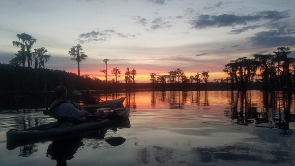
Venus gleamed through the fires of sunset as the full moon and Mars hid behind clouds.

Sunset, On the water

The sound of frogs brought out swoops of bats, as a dozen or two paddlers braved the placid flat waters of Banks Lake Friday evening in the least strenuous yet one of the most enjoyable of all WWALS outings. As one new participant remarked, it’s one thing to see it from the road, but out on the water the size, the lucidity, and the sunset are startling while calming.

Bret Wagenhorst, who brought a crew of new people from Tifton and paddled out with them first, reports: “Got to see: ospreys and nest, eastern kingbirds, egrets, ibises, bats, gators and hear Continue reading

Withlacoochee River near Troupville 2018-07-21

Got some deadfalls in the Withlacoochee River at Troupville, Valdosta, Lowndes County, Georgia, on the Withlacoochee and Little River Water Trail (WLRWT), found once again by intrepid WWALS explorer Aaron Sirmons. Here are some pictures and a Google map.

[Log in tree, 2018:07:14 10:02:25, 30.8495694, -83.3402911]
Log in tree, 2018:07:14 10:02:25, 30.8495694, -83.3402911

Troupville, the old county seat of Lowndes County, Georgia, was mostly west of the Withlacoochee River over to the Little River and down to its confluence, although as you can see in this map Troupville Cemetery was to the east of the Withlacoochee River.

[Withlacoochee River at GA 133 in the WWALS map of the Withlacoochee and Little River Water Trail (WLRWT)]
Withlacoochee River at GA 133 in the WWALS map of the Withlacoochee and Little River Water Trail (WLRWT)
This is a still image from the interactive Google map.

WWALS did a cleanup recently down to the Confluence, by permissionon private land that is for sale. All about the history of Troupville. You could start at Troupville Boat Ramp and paddle a week downstream on the Withlacoochee and Suwannee Rivers, even in June.

[Beavers?, 2018:07:14 10:02:45, 30.8491566, -83.3404211]
Beavers?, 2018:07:14 10:02:45, 30.8491566, -83.3404211

Trash, River
Trash, River

Start of cutoff, Oxbow cutoff

Narrow, Oxbow cutoff

Deer stand, Oxbow cutoff

[Deer stand, 2018:07:14 10:11:39, 30.8472271, -83.3428214]
Deer stand, 2018:07:14 10:11:39, 30.8472271, -83.3428214

Reflections, Oxbow cutoff

Wider, Oxbow cutoff
Wider, Oxbow cutoff

Deadfall ready to block entire river, Oxbow cutoff

[Side deadfall, 2018:07:14 10:17:13, 30.8461670, -83.3430003]
Side deadfall, 2018:07:14 10:17:13, 30.8461670, -83.3430003

[End of cutoff, 2018:07:14 10:18:11, 30.8467601, -83.3425382]
End of cutoff, 2018:07:14 10:18:11, 30.8467601, -83.3425382

Trees, Downstream

[Trees, 2018:07:14 10:41:51, 30.8479584, -83.3408428]
Trees, 2018:07:14 10:41:51, 30.8479584, -83.3408428

[Power line, 2018:07:14 10:52:08, 30.8499246, -83.3400640]
Power line, 2018:07:14 10:52:08, 30.8499246, -83.3400640

[Submerged deadfall, 2018:07:14 11:14:34, 30.8519610, -83.3391584]
Submerged deadfall, 2018:07:14 11:14:34, 30.8519610, -83.3391584

 -jsq, John S. Quarterman, Suwannee RIVERKEEPER®

You can join this fun and work by becoming a WWALS member today!

Google Map

Follow this link for the interactive google map, or it’s also embedded below. This map also includes the deadfall upstream from I-75 of Aaron’s other report.

Deadfall, Withlacoochee River, upstream of I-75, 2018-07-21

Update 2018-07-24: Deadfalls and an oxbow cutoff downstream by Troupville, with a map including the deadfall in this post.

Yet another deadfall in the Withlacoochee River, this one just upstream from the I-75 bridge, discovered by intrepid WWALS explorer Aaron Sirmons.

Deadfall middle, Deadfall
Deadfall

Finding out what’s in the rivers is part of the Withlacoochee and Little River Water Trail (WLRWT).

More pictures: Continue reading

Pictures of all the BLRPR paddlers 2018-04-28

You’ve seen who won the eleven awards. Now here are the rest of the paddlers in the 6th Annual BIG Little River Paddle Race, from more counties, states, and watersheds than ever before. Also more Solo Female Kayaks than Solo Male Kayaks, and several whole families of paddlers.

[Finish]
Finish

Statistics: 2018 BIG Little River Paddle Race

43 Boats 
37 kayaks
6 canoes

49 Paddlers
29 male
20 female Continue reading

Cleanup at Sheboggy plus upstream paddle Alapaha River 2018-09-09

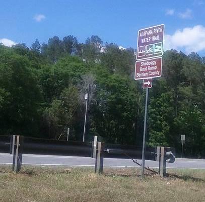
The traditional annual WWALS Sheboggy Georgia Adopt-A-Stream cleanup at Sheboggy, plus an upstream paddle, from this most upstream of the access points on the Alapaha River Water Trail (ARWT). Oh, and we still want those Sheboggy road signs back.

When: 1 PM, Sunday, September 9, 2018

Put In: Sheboggy Boat Ramp, 11004 US Highway 82, Alapaha, GA 31622, a few miles east of Alapaha, Georgia, in Berrien County.

GPS: 31.386279, -83.191609

Take Out: Sheboggy Boat Ramp

Bring: the usual personal flotation device, boat paddles, food, drinking water, warm clothes, and first aid kit. Also trash pickers and trash bags: every WWALS outing is also a cleanup.

Free: This outing is free to WWALS members, and $10 (ten dollars) for non-members for the paddle (the cleanup is free to everyone). We recommend you support the work of WWALS by becoming a WWALS member today!

Event: facebook, meetup

Sign, Last Seen
Sheboggy road signs last seen, April 27, 2018. Photo: Jack Hickox; we still want them back.

Continue reading