Category Archives: Law

Entering Floridan Aquifer Recharge Zone

Maybe we need signs like that around here to remind people that what goes into the ground comes out in our drinking water. For example, San Antonio has its Edwards Aquifer Protection Program. Maybe our local governments need to have Floridan Aquifer Protection Programs. Georgia state law seems to indicate they should.

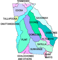
GA Secretary of State has GA Code §391-3-16-.02 Criteria For Protection of Groundwater Recharge Areas. (more legible copy on GA EPD website),

Georgia's Groundwater Recharge Areas (1) Background. Variable levels of recharge area protection can be based upon the State’s hydrogeology (e.g., areas such as the Dougherty Plain where a major aquifer crops out would receive a relatively high degree of protection whereas other areas, such as the shale hills of northwest Georgia, would receive a lower degree of protection). Recharge area protection within the significant recharge areas would be further refined, based upon the local susceptibility or vulnerability to human induced pollution (e.g., high, medium, or low). The significant recharge areas have already been identified and mapped (about 22-23% of the State). Pollution susceptibility mapping is ongoing. Existing statutes are adequate for protecting the remaining recharge areas (about 77-78% of the State).

[…]

(2)(f)3. In the Coastal Plain, the significant recharge areas are Continue reading

JIA map shows all marsh as land at mean high tide –David Egan

Received Thursday on Marsh is not land, not here, not at Jekyll Island –WWALS Watershed Coalition -jsq

WWALS Watershed Coalition is on target with its analysis of the Jekyll 65-35 issue! Just a quick glance at the the 65-35 map under consideration by the JIA reveals all —- according to the JIA, ALL of Jekyll’s tidal marsh is above water, as in dry, at mean high tide, and is therefore part of the land area of Jekyll Islnsd subject to the 65-35 law. On-site conditions deny the accuracy of that map, for most of the marsh is actually under water (as in wet) at the time of high tide. The JIA’s map can be viewed at http://www.savejekyllisland.org/MPMOAAMHWPapJuly2013.html

-David Egan


SaveJekyllIsland.org wrote: Continue reading

Marsh is not land, not here, not at Jekyll Island –WWALS Watershed Coalition

Unanimously approved Wednesday by the WWALS board (PDF). JIA meets next Monday 15 July 2013.

From:
WWALS Watershed Coalition
3338 Country Club Road #L336
Valdosta, GA 31605
www.wwals.net
10 July 2013

To:
Governor Nathan Deal,
Attorney General Sam Olens,
the Jekyll Island Authority,
and the Georgia Legislature

Frog viewing swamp Here in central south Georgia our pocosin swamps and blackwater river flood plains are important for fishing, hunting, wildlife and ecological preservation as well as recreation and flood control. In our watersheds we have serious problems of flooding at least partly due to Continue reading

Ask Georgia Power to conserve our water –WWALS to GA PSC

Approved 12 June 2013 by unanimous vote of the WWALS board, Dave has mailed a signed copy to the Georgia Public Service Commission, and I will go read it to the PSC Tuesday morning at 10 AM 18 June 2013, at their hearing about

Docket 36498, Georgia Power Company’s 2013 Integrated Resource Plan and Application for Decertification of Various Units
and
Docket 36499, Application for the Certification of Amended Demand Side Management Plan

Y’all come! -jsq

From: WWALS Watershed Coalition, Inc.
3338 Country Club Road #L336
Valdosta, GA 31605
12 June 2013

To: Georgia
Public Service Commission

244 Washington Street, SW
Atlanta GA, 30334-9052

Dear Public Service Commissioners and Staff,

The recent rains have swollen our blackwater rivers, Withlacoochee, Willacoochee, Alapaha, and Little, under our longleaf pines and Spanish-moss-covered oaks, and filled up the tea-colored tannin waters in our frog-singing pocosin cypress swamps here in central South Georgia. But that was only a dent in our protracted drought that ranges from mild to extreme, with projections not much better.

We do not need more traditional big baseload power plants gulping down our river or aquifer water when solar and wind power use far less, and those renewables are now at grid parity with coal, natural gas, and nuclear.

Power plants are thirsty, as the Union of Concerned Scientists pointed out in a 2011 report, “Freshwater Use by U.S. Power Plants: Electricity’s Thirst for a Precious Resource”.

Much of the water used to cool power plants evaporates, and is Continue reading

Nonpoint Source Pollution biggest water quality problem –EPA

EPA found phosphorus and nitrogen from fertilizers, bacteria and other pollutants from urban runoff, plus mercury, in most U.S. rivers and streams. And they didn’t even mention low dissolved oxygen.

Ian Simpson wrote for Reuters, carried by NBC, EPA: More than half of U.S. rivers unsuitable for aquatic life,

Fifty-five percent of U.S. river and stream lengths were in poor condition for aquatic life, largely under threat from runoff contaminated by fertilizers, the U.S. Environmental Protection Agency said on Tuesday.

High levels of phosphorus and nitrogen, runoff from urban areas, shrinking ground cover and pollution from mercury and bacteria were putting the 1.2 million miles of streams and rivers surveyed under stress, the EPA said.

“This new science shows that America’s streams and rivers are under significant pressure,” Nancy Stone, acting administrator of the EPA’s Office of Water, said in a statement.

Twenty-one percent of the United States’ river and stream length was

Continue reading

Reservoirs for control of stormwater –Tim Carroll

Valdosta City Council Tim Carroll spoke about the need for watershed-wide planning to reduce flooding and provide water for agriculture with distributed flood containment reservoirs. He referred to the materials he sent in advance as well as to some additional data about water quality measurements upstream and downstream of selected points. And he sent an update the next day.

Tim Carroll noted that one thing that was clear from the Valdosta City Manager Larry Hanson’s 2010 presentation to the Suwannee-Satilla Water Council about the 2009 flood was that the drainage basin study proposed by that Council (which completed its report and disbanded) still needs to be completed. For that purpose, Hanson had just sent a letter to the Army Corps of Engineers requesting assistance. Apparently they have partial answer, and they’re also talking the state.

Carroll said that with the renewed attention to flooding problems Continue reading

Hotchkiss Landing Closed

On Tuesday evening, the Lowndes County Board of Commissioners voted 3-1, with one commissioner absent to close Hotchkiss Landing, the only public access to the Alapaha River in Lowndes County. The only commissioner to vote against the closure of the road was Demarcus Marshall, and I would like to thank him for listening to the public on this issue, and ultimately deciding on its merit.

Lead, arsenic, and uranium in water causing cancer –Janet McMahan

Uranium? Yes, really: it comes out of granite rocks up deep water wells in the Georgia Piedmont. The other metals arsenic come from human energy, industrial, and agricultural activities, ranging from fenceposts to Plant Scherer, dirtiest coal plant in the country, emitting mercury, some of which ends up in the Alapaha River. Here’s video of Janet McMahan speaking about this:


Janet McMahan spoke to the group after the
Adopt-A-Stream water quality testing training
taught by Angela Bray and Richard Batten.
Video by Gretchen Quarterman for WWALS Watershed Coalition (WWALS),
Valdosta, Lowndes County, Georgia, 5 August 2012

Janet McMahan adds:

Continue reading

Rules for river corridor protection –GA EPD

Georgia Lakes, Rivers and Water Resources So Georgia state law requires protection for perennial river corridors and the major rivers in the WWALS watersheds qualify as perennial rivers. What are the rules? Apparently to be a “Qualified Local Government” a comprehensive plan including River Corridor Protection Plans with protection for a natural vegetative buffer area bordering each protected river is required.

Rules of Georgia Department of Natural Resources,
Environmental Protection Division
Chapter 391-3-16
Rules for Environmental Planning Criteria

391-3-16-.04 Criteria for River Corridor Protection

Georgia Rivers (1)(b) The Comprehensive Georgia Planning Act of 1989 provides for the development of coordinated and comprehensive planning by municipal and county governments. Such comprehensive plans shall consider the natural resources, environments, and vital areas within the jurisdiction of the local government. Maintenance of the status as a “Qualified Local Government” is contingent upon the development of such comprehensive plans (O.C.G.A. 50-8-1 et seq.).

Continue reading