Tag Archives: planning

Applicant slides and sound recording, 2,109-acre PUD, Chiefland, FL 2024-06-24

Update 2024-08-12: Packet: Return of the proposed 2,109-acre rezoning for Planned Unit Development in floodplain –City of Chiefland, FL 2024-08-12.

Here is audio of the applicant’s answers to citizen questions in the June 24, 2024 Chiefland City Commission meeting, as well as the applicant’s slides.

[Applicant slides, sound recordings 2024-06-24, Proposed 2,109-acre PUD, Chiefland, FL, Manatee Springshed]
Applicant slides, sound recordings 2024-06-24, Proposed 2,109-acre PUD, Chiefland, FL, Manatee Springshed

If somebody wants to transcribe these audio files, that would be most helpful.

Here is part 1 of audio from the June 24, Chiefland City Commission meeting:

Continue reading

Proposed 2,109-acre rezoning for Planned Unit Development in floodplain –City of Chiefland, FL 2024-07-08

Update 2024-08-12: Packet: Return of the proposed 2,109-acre rezoning for Planned Unit Development in floodplain –City of Chiefland, FL 2024-08-12.

Update 2024-07-20: Applicant slides and sound recording, 2,109-acre PUD, Chiefland, FL 2024-06-24.

The City of Chiefland has an application for a 2,109-acre Planned Unit Development with a 50-year plan for residential, commercial, industrial, and other uses, in an area now zoned as Agricultural / Rural Residential. It is mostly in the floodplain of Long Pond, and upstream of the Suwannee River.

[2,109-acre 50-year PUD rezoning, in Agricultural / Rural Residential Area, Floodplain upstream from Suwannee River, City of Chiefland, FL 2024-07-08]
2,109-acre 50-year PUD rezoning

A development where “when you live in the development you don’t have to leave” is not a bad idea. But the location is unfortunate.

Fortunately, the applicant pulled the agenda item for yesterday’s Chiefland City Commission meeting. Chiefland City Hall told me he would resubmit when he thinks he’s ready. So watch for it reappearing.

Two weeks before, many citizens asked many questions. The minutes for that June 24, 2024, City Commission meeting says a representative of the applicant answered all the questions, but the minutes do not say what the answers were.

The agenda for July 8 also does not say what the answers were.

If you oppose this rezoning, you can use the time to organize before the application re-appears.

You may want to consider joining the public facebook group RURL Residents United for Rural Levy.

Apparently the connection to the Suwannee River may involve an underground section. Continue reading

Packet: Levy County Planning Commission, with 3RT Sand Mine Special Exception application 2023-07-10

Update 2023-07-23: Levy County 3RT Sand Mine is in Springshed of Rainbow Springs 2023-07-23.

Only one Levy County Planning Commissioner, a former miner, voted against recommending a Special Exception for a proposed 1,100-acre sand mine, after 70 people testified for four hours under oath that the mine is a bad idea in a rural residential agricultural area.

The county mailed about 2,800 notices in April to residences within two miles of the site, because of the large number of truck trips that would be required, about one every 90 seconds.

When this case comes up before the Board of County Commissioners of Levy County, I recommend interested parties show up and speak. And meanwhile send them a letter or call them.

If approved, this mine will be there for 40 years, and maybe 100 years.

[Collage, 3RT Sand Mine, Levy Count Planning Commission Packet 2023-07-10]

This case will not be heard by the Levy County Commission at its next meeting on Tuesday, July 25, 2023, because on July 18th the Planning & Zoning Office received official notice from the 3RT Sand Mine (SE 23-01) applicant, Ryan Thomas, requesting a continuation to a date uncertain to have time to assess the project with the Planning Commission conditions.

This is a standard developer tactic: delay hoping the opposition will forget. I recommend the opposition keep on it.

The Levy County parcels of the mine site and other parcels proposed for access are shown in yellow on this map. Manatee Spring on the Suwannee River is highlighted towards the left. Levy County staff wrote, “e) Site is not located within one mile corridor (one-half mile on either side) of known geological features with the potential to Impact Manatee Springs or Fanning Springs. Additional study is not recommended to be required.” Apparently the staff believe what DNM Engineering & Associates, Inc., told them on behalf of the miners. I’d prefer to see further study. Continue reading

WWALS to Valdosta: please deny deannexation of Cherry Creek Mitigation Bank 2021-08-05

Update 2021-08-31: Denied: Deannexation of Cherry Creek Mitigation Bank @ VCC 2021-08-05.

August 5, 2021 (see also PDF)

To: Matt Martin, Valdosta City Planner, mlmartin@valdostacity.com

Re: Please deny VA-2021-16 Deannexation Request by Uvalde Land Company

Dear Planner Martin,

WWALS Watershed Coalition, Inc. asks the Valdosta Mayor and Council to deny deannexation of half of the Cherry Creek Mitigation Bank (CCMB) in VA-2021-16 at its meeting this Thursday, August 5, 2021. As you know, the Greater Lowndes Planning Commission (GLPC) already voted 6-3 to recommend against deannexation.

[Location, Sinkholes]
Location, Sinkholes

Given the lack of any good reasons by the applicant for deannexation of that 310 acres of Withlacoochee River floodplain around Cherry Creek, let me remind everyone of some reasons not to deannex.

The CCMB is directly across the Withlacoochee River from Shadrick Sink. Valdosta already had to sink its water wells on Guest Road twice as deep because of river water going into Shadrick Sink, then through ground water several miles east to those wells. The choice was to pay for much more expensive methods to deal with tannic acid and biological components of the river water, or dig the wells deeper. This is literally a textbook case: Continue reading

Withlacoochee River floodplain deannexation at Valdosta City Council 2021-08-05

Update 2021-08-05: WWALS to Valdosta: please deny deannexation of Cherry Creek Mitigation Bank 2021-08-05.

Thursday evening the Valdosta City Council decides whether to deannex 310 acres of Withlacoochee River floodplain around Cherry Creek, uphill from the Withlacoochee River.

The Greater Lowndes Planning Commission voted 6-3 to recommend denial, apparently deciding no good reason for deannexation was given by the applicant. There are substantial reasons to be concerned about potential uses of that land if deannexed.

Instead, Valdosta and Lowndes County should purchase the entire 530.24 acre property down to the Withlacoochee River to add to a trails system up along the Withlacoochee River, connecting with the Withlacoochee and Little River Water Trail all the way down to the future Troupville River Camp.

[Location, Agenda]
Location, Agenda

It’s a Public Hearing, so you can speak. Or go ahead and send a letter to Valdosta City Planner Matt Martin: mlmartin@valdostacity.com

 -jsq, John S. Quarterman, Suwannee RIVERKEEPER®

You can join this fun and work by becoming a WWALS member today!

[Cherry Creek Mitigation Bank, Withlacoochee River to future Troupville River Camp]
Cherry Creek Mitigation Bank, Withlacoochee River to future Troupville River Camp in the WWALS map of the Withlacoochee and Little River Water Trail.

Why Withlacoochee River floodplain deannexation from Valdosta? @ GLPC 2021-07-26 2021-07-26

Update 2021-08-02: Withlacoochee River floodplain deannexation at Valdosta City Council 2021-08-05.

Valdosta should not deannex 310 acres of Withlacoochee River floodplain around Cherry Creek. No good reason for deannexation has been given by the applicant, and there are substantial reasons to be concerned about potential uses of that land if deannexed. Instead, Valdosta and Lowndes County should purchase the entire 530.24 acre property down to the Withlacoochee River to add to a trails system up and down the Withlacoochee River. The advisory Greater Lowndes Planning Commission (GLPC) at its meeting this Monday should recommend against annexation, and then the Valdosta Mayor and Council should deny.

I am sending a letter to that effect today to Valdosta City Planner Matt Martin, and I recommend you do, as well: mlmartin@valdostacity.com

[Public land and Uvalde Land Trust Deannexation request, Withlacoochee River]
Public land and Uvalde Land Trust Deannexation request, Withlacoochee River

That deannexation is on the GLPC agenda for this Monday, July 26, 2021. The only land access to the property is through the City of Valdosta, and since that whole area of the river has extensive flood plain and little road access, Lowndes County cannot provide public utilities, fire/police protection, or emergency medical response across the river to the subject property, as the City Planner points out in the agenda sheet. The landowner’s stated purpose would be better served by the property remaining inside the city limits: “to use for wildlife management, and rec. use as it is in a mitgation bank & has no development use.” The City Planner even recommends annexing the rest of the subject property into the city, down to the river. Continue reading

VSU Geology and ASA at Land Between the Rivers 2019-11-26

Two Geology Professors visited The Land Between the Rivers and wrote a letter about many projects they and their students can do there, at the site of Troupville Boat Ramp. This is more in-kind match for the GOSP grant pre-application.

[Prof. Don Thieme & Can Denizman, 13:30:33, 30.8515417, -83.3452859]
Prof. Don Thieme & Can Denizman, 13:30:33, 30.8515417, -83.3452859

Letter from Donald M. Thieme, Associate Professor, Geology, Valdosta State University (VSU):

[Donald M. Thieme, Associate Professor, Geology, VSU]
Donald M. Thieme, Associate Professor, Geology, VSU
PDF

I am very pleased and excited about the proposal by WWALS to develop the Troupville River Camp. The property in question is Continue reading

Bradford County, FL Comprehensive Plan 2012-04-19

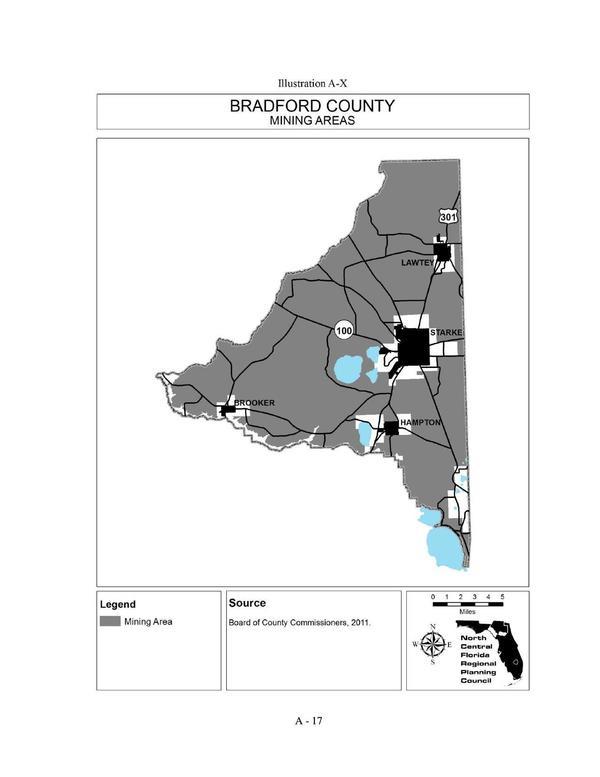
Apparently you can mine almost anywhere in Bradford County, Florida, according to the Bradford County Comprehensive Plan:

Illustration A-X Bradford County MINING AREAS

That map is about as bad as the one in Continue reading

2018 5-year update of SGRC Regional Plan Kick-off 2017-08-24

Received 21 August 2017:

Good Morning Everyone,

This email is to inform you that the Southern Georgia Regional Commission is formally kicking off its 2018 5-year update of the SGRC Regional Plan. The initial kick-off public meeting will be held during the regular SGRC Board meeting on:

Thursday, August 24, 2017
11 a.m. or soon thereafter
City of Pearson Sports Complex and Civic Center,
786 Austin Ave East, Pearson

Page 13: Conservation and Development Map

The purpose of this kick-off hearing is to Continue reading

Vallotton Farms upstream from Withlacoochee Sinks

Update 2017-09-13: The Lowndes County Commissioners surprisingly agreed to rezone “backwards” to Estate A gricultural (E-A) at their Regular Session of 14 April 2015.

300x172 Withlacoochee Sinks downstream from Cherry Creek and Vallotton Farms, in Vallotton Farms, by John S. Quarterman, for WWALS.net, 30 March 2015 A historic dairy farm wants to go back to the most agricultural zoning, upstream on Cherry Creek from the Cherry Creek Sink that leaks into the Floridan Aquifer. Vallotton Farms (both the part outlined in red that appears to be the subject of the rezoning and the bigger part west of Bemiss Road) includes quite a bit of Cherry Creek itself. Agriculture is probably better than other likely uses in such a location. Continue reading