Homerville explosion from pipeline starting in Lowndes County 2018-08-17

Gas from a tiny pipeline demolished a business and sent three women to the hospital yesterday with third-degree burns, plus it shut down Homerville, Georgia, for a day.
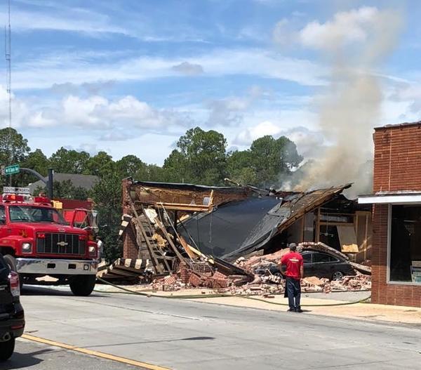
Hosing down remains of Coffee Corner, Clinch County News
Hosing down remains of Coffee Corner, Clinch County News, photo by Laura Nipper.

First and most detailed with this story is Clinch County News, and it has been carried by the Associated Press all over the U.S. and beyond.

Apparently only WCTV thought to ask about the pipeline, which is owned by Atlanta Gas Light, aka AGL Resources, and since Southern Company bought that in 2016, Southern Company Gas. Unless Southern Company comes back with a different route, the maps say that pipeline starts in Lowndes County, Georgia, on my property.

Here is Noelani Mathews of WCTV reporting about the Sabal Trail pipeline in January 2016, from where that AGL pipeline takes off from the Southern Natural Gas (SONAT) pipeline to Nashville, Georgia, which was broken by Continue reading

Video: Hollin Gammage singing Little River at SuwRK Songwriting Contest

Hollin Gammage, from McMinnville, Tennessee, outside the Suwannee River Basin, sang “Little River,” and won a prize for Best Americana, at the First Annual Suwannee Riverkeeper Songwriting Contest, Saturday, June 23, 2018, at the Salty Snapper, Valdosta, GA.

Hollin Gammage
Hollin Gammage (photo by Bret Wagenhorst)

I think we’ve all been “Half crazy til I hit the water.”

Here’s the video: Continue reading

Rivers bigger and more important that previously thought 2018-06-28

Rivers and streams cover more of the earth’s surface than previously thought, and likely interchange more CO2 and other gases with the atmosphere than previously thought. WWALS Science Committee Chair Tom Potter found this paper.

George H. Allen and Tamlin M. Pavelsky, Science, 28 Jun 2018, DOI: 10.1126/science.aat0636 Global extent of rivers and streams,

Abstract

The turbulent surfaces of rivers and streams are natural hotspots of biogeochemical exchange with the atmosphere. At the global scale, the total river-atmosphere flux of trace gasses such as CO2 depends on the proportion of Earth’s surface that is covered by the fluvial network, yet the total surface area of rivers and streams is poorly constrained. We used a global database of planform river hydromorphology and a statistical approach to show that global river and stream surface area at mean annual discharge is 773,000 ± 79,000 km2 (0.58 ± 0.06%) of Earth’s non-glaciated land surface, an area 44 ± 15% larger than previous spatial estimates. We found that rivers and streams likely play a greater role in controlling land-atmosphere fluxes than currently represented in global carbon budgets.

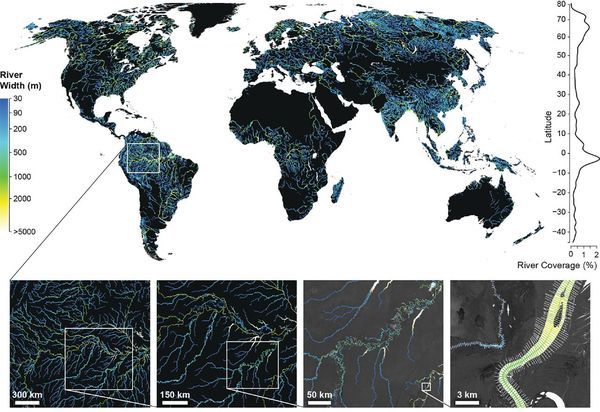
Fig. 1. Global River Widths from Landsat (GRWL) Database, Figure
Fig. 1. The Global River Widths from Landsat (GRWL) Database contains more than 58 million measurements of planform river geometry. The line plot on the right shows observed river coverage as a percentage of land area by latitude, and the bottom insets show GRWL at increasing zoom. The rightmost inset shows GRWL orthogonals over which river width was calculated, with only every eighth orthogonal shown for clarity.

You can see the lower Suwannee River in the above figure.

The authors zoom in on the Amazon River Basin in Brazil, but those last two zooms could easily be Continue reading

Brochures: Trails Committee Meeting 2018-08-19

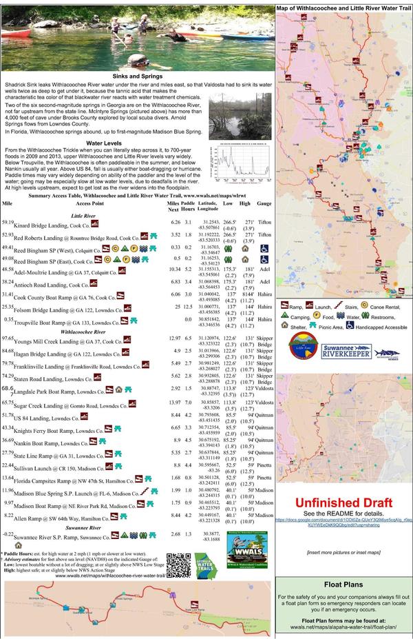
After only four years, we’re almost finished with both WWALS Water Trails! You can help get them done.

The new Chair of the WWALS Trails Committee, Dan Phillips, has called a meeting to work on one of the final steps: designing printed brochures. Anyone can attend, and anyone can send in pictures or suggestions.

Please email pictures to wwalswatershed@gmail.com. Please say who took each picture, when, where, and of what. High resolution, please.

When: 2:30-5PM, Sunday, 19 August 2018

Where: Community Hall 2,
South Georgia Regional Library,
2906 Julia Dr, Valdosta, GA 31602

By phone: Dial-in Number: (641) 715-3580
Meeting ID: 855-676

Event: facebook, meetup

WLRWT Mapside, WLRWT

If you want to join the WWALS Trails Committee to help continue organizing this work, actually editing the documents shown below, you must be Continue reading

Organizational meeting, WWALS Water Quality Testing Committee 2018-08-21

After years of trying to get local or state governments to do it, WWALS is starting a water quality monitoring program.

The new Chair of the WWALS Water Quality Testing Committee, Bobby McKenzie, has called an organizational meeting. Anyone can attend, and anyone can send in reports. Please sign up for Water Reporter at waterreporter.org, and join the Suwannee Riverkeeper group.

Suwannee Riverkeeper group, Water Reporter

When: 5-7:45 PM Tuesday 21 August 2018

Where: Community Hall 2,
South Georgia Regional Library,
2906 Julia Dr, Valdosta, GA 31602

By phone: Dial-in Number: (641) 715-3580
Meeting ID: 855-676

Event: facebook, meetup

If you want to join the WWALS Water Quality Testing Committee, you must be a WWALS member and apply.

The meeting will be about Continue reading

135,000 gallons from Valdosta Mud Creek Wastewater Treatment Plant 2018-08-13

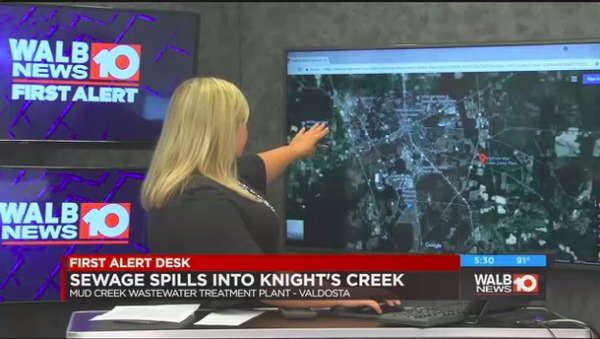
Valdosta spilled again, and again bigger than any recently from Albany or Tifton. This news was first seen on WALB TV out of Albany 5:10 PM last night. Valdosta sent email to WWALS at 10:17 PM.

Should Suwannee Riverkeeper have to watch WALB in Albany to learn first about a wastewater spill in Valdosta, the biggest city in the Suwannee River Basin?

More importantly, if “Spills of any nature are unacceptable,” why do you keep having them, Valdosta? Especially with only 1.5 inches of rain? What will you do in another tropical storm or hurricane? And how and when will we know?

WALB TV, TV

Krista Monk, WALB TV, 5:10 PM, 14 August 2018, City of Valdosta reports 135K gallon sewage spill, Continue reading

Lowndes County lift station pumps 2018-08-13

Once again the Lowndes County Commission considers replacing a lift station pump at Bevel Creek. The agenda sheet says:

The Bevel Creek lift station is a triplex lift station on our main trunk line that delivers over 60% of our wastewater flow to the LAS. This station is currently running on two pumps. We have a quote from AAG Inc. to repair the pump that is out of service for $13,971.04. Staff recommends the pump be repaired for $13,971.04.

Replacing that pump sounds like a good idea. LAS is Land Application Site, as in spray field, a few thousand feet from the GA-FL state line and slightly upstream from the Withlacoochee River. Lowndes County does not have a wastewater treatment plant, and nobody wants sewage leaking at Bevel Creek or at the LAS.

Lowndes County Utilities Director Steve Stalvey
Lowndes County Utilities Director Steve Stalvey, 8 May 2018.

I do wonder, though, why we’re needing to replace a pump at Bevel Creek again, after just replacing Continue reading

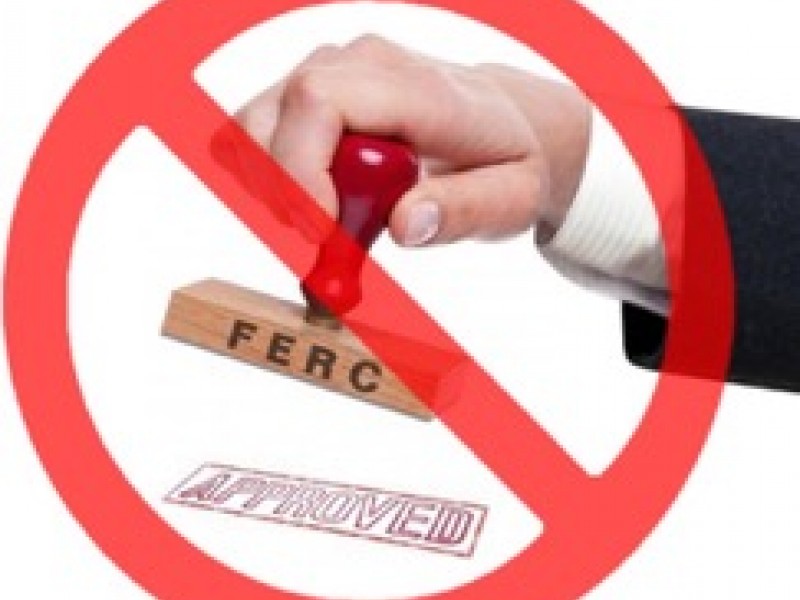
FERC rubberstamps four rehearing denials and a new pipeline on a Friday 2018-08-10

Scurrying to use its rubberstamp before a Commissioner departing leaves it tied 2:2, FERC once again rubberstamped multiple pipelines, this time three on a Friday plus an LNG export project, while neither its main online library nor its backup library yielded copies of the orders.

I found these four by googling:

  • 164 FERC ¶ 61,099 Florida Southeast Connection, LLC Transcontinental Gas Pipe Line Company, Sabal Trail Transmission, Docket Nos. CP14-554-003, LLC CP15-16-004, LLC CP15-17-003, ORDER DENYING REHEARING, Issued August 10, 2018
  • 164 FERC ¶ 61,098, PennEast Pipeline Company, LLC, Docket No. CP15-558-001, ORDER ON REHEARING, August 10, 2018.
  • 164 FERC ¶ 61,100, Atlantic Coast Pipeline, LLC, Dominion Transmission, Inc., Atlantic Coast Pipeline, LLC, Piedmont Natural Gas Company, Inc., Docket Nos. CP15-554-002, CP15-555-001, CP15-556-001, Order on Rehearing, August 10 2018.
  • 164 FERC ¶ 61,102, Dominion Energy Cove Point LNG, LP, Docket No. CP17-15-001, ORDER DENYING REHEARING, August 10, 2018.

Oh, wait, a mention of a docket number in a FERC agenda leads me to one more Friday rubberstamp, of a new Transco pipeline in New Jersey:

FERC rubberstamp

  • 164 FERC ¶ 61,101, Transcontinental Gas Pipe Line Company, LLC, Docket No. CP17-490-000, ORDER ISSUING CERTIFICATE, August 10, 2018.

Commissioner Cheryl A. LaFleur dissented from Continue reading

Bob’s River Place variances 2018-08-14

The Bob’s River Place agenda item on the SRWMD agenda for August 14, 2018 turns out to be the latest in year-long series. Every time I’ve stopped by it’s been closed, so I have no dog in this fight. I’m merely presenting what I’ve dug up in a few minutes by following leads backwards. This agenda-and-minute trail is probably incomplete, but what I’ve found tells a tale about SRWMD granting permits, then receiving citizen complaints including about safety. After which it seems SRWMD discovered numerous structures and other features that had been operational for years, yet had not been permitted.

[Slip and slide ramp removed from permit application 2/5/2013 yet constructed 4/7/2017]
Slip and slide ramp removed from permit application 2/5/2013 yet constructed 4/7/2017
PDF

FAR 2018-01-17

Starting with the earliest mention I’ve found in this series and going forwards, Florida Administrative Register, Volume 44, Number 11, January 17, 2018, Continue reading

Packet, SRWMD Board, 2018-08-14

The many interesting items on the agenda for next Tuesday morning’s SRWMD board meeting in Live Oak, include a springs campaign discussion, water withdrawals, creek clearing in Bradford County, and the latest in a long-running series about Bob’s River Place in Dixie County.

When: 9AM Tuesday, August 14, 2018

Where: 9225 CR 49, Live Oak, FL 32060

See also the other post about Bob’s River Place.

 -jsq, John S. Quarterman, Suwannee RIVERKEEPER®

You can join this fun and work by becoming a WWALS member today!