
Withlacoochee River at GA 223


We talked about outings at 7:30 as scheduled, although it’s not clear who could hear. The whole St Augustine Rd area is dark, including Black Crow’s online streaming. We’re scheduling another time for next week. And thanks to Chris and the crew who camped out in the station all night!

Chris Beckham asked if we would reschedule the Suwannee River outing. Yep, delayed until Monday due to weather.
Here are Continue reading
It looks like Hermine will have moved along east by Saturday, or at least by Sunday, which is the fallback date for the WWALS paddle outing this weekend from Redoux Suwannee River Roline to Cypress Creek. We won’t be able to tell for a day or so what the situation will be, but so far we’re still planning on Saturday morning. Expedition leader Phil Hubbard will make a determination before then.

-jsq
You can join this fun and work by becoming a WWALS member today!
An easy hike following Alapaha River as it flows into the Dead River
and disappears into the Dead River Sink: you don’t see this just anywhere!.

Update 2016-10-15: Be aware the path does get steep and rough towards the sink, and there are mosquitoes and chiggers.
Bring water, a snack, and bug repellent.
No boat required. Really: you don’t want to try to boat up the Dead River. But you do want to see the Dead River Sink.
When: 10AM Saturday November 6th 2016
Duration: 2-3 hours
Where: Jennings Bluff Landing, 30.579864, -83.039308
This outing is Free! But we encourage you to join WWALS today to support our fun outings and important work: /donations/. Continue reading
8AM Friday morning WWALS will be on Chris Beckham’s drive-time radio show.
![]() WWALS president John S. Quarterman will be talking about
Saturday morning’s Suwannee River paddle outing
and other outings upcoming on the Alapaha and Withlacoochee Rivers,
along with other developments on the
Alapaha River Water Trail and the
Withlacoochee and Little River Water Trail,
along with
many other things WWALS does.
Plus what you can do about
the FERC rubberstamp of the Sabal Trail fracked methane pipeline
drilling under the Withlacoochee and Suwannee Rivers.
WWALS president John S. Quarterman will be talking about
Saturday morning’s Suwannee River paddle outing
and other outings upcoming on the Alapaha and Withlacoochee Rivers,
along with other developments on the
Alapaha River Water Trail and the
Withlacoochee and Little River Water Trail,
along with
many other things WWALS does.
Plus what you can do about
the FERC rubberstamp of the Sabal Trail fracked methane pipeline
drilling under the Withlacoochee and Suwannee Rivers.
When: 8:00 7:30AM Friday September 2nd 2016
Where: Continue reading
Update 2017-04-28:
Sandhills and wildlife at Alapaha WMA
WWALS is gratified that people are contacting us about the WMA,
but we’re just reporting on it, we do not run it.
Contact information for the Alapaha WMA:
Greg Nelms,
Wildlife Biologist, Game Management,
Wildlife Resources Division, GA-DNR
(229) 426-5267 | M: (404) 985-6424
Update 2016-10-20: WMA check-in hunt does not count towards Georgia bag limit.
Update 2016-10-18: Video of Deserter Lake in the Alapaha WMA and hunting dates and bag limits.
Halfway between Tifton and Ocilla on the Alapaha River in Irwin County,
apparently announced only by a public hearing in July about hunting reglations:
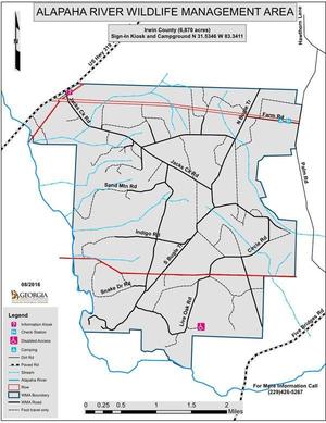 the new 7,000-acre Alapaha River Wildlife Management Area (WMA).
There’s an information kiosk off of US 319.
the new 7,000-acre Alapaha River Wildlife Management Area (WMA).
There’s an information kiosk off of US 319. , with the sign-in kiosk and campground across the WMA:
from Ocilla take US 319 S, left onto Hawthorn Ln, right onto Palm Rd, right onto Farm Rd.
Update 2016-08-30: According to Greg Nelms, Wildlife Biologist, DNR, the main entrance will be off of US 319; there is already a WMA sign there. It’s not quite open yet; they’re still working on roads. A ribbon cutting is scheduled for September 30th. The first hunting season will be an archery hunt on October 1st; hunters can go in at noon the previous day to set up stands.
Here’s the announcement of the public hearing: GA DNR/Wildlife Resources Division/Game Management, 6 July 2016, Proposed Regulations for Alapaha River WMA; Public Hearing Scheduled,
The new regulations, probably adopted unchanged, and which seem to consist of dates and conditions for hunting seasons for various game animals, are online here.
Several maps are linked in for Continue reading
Sites in WWALS watersheds include Paradise Public Fishing Area (PFA)
at the headwaters of our Withlacoochee River,
 Reed Bingham State Park on our Little River,
Grand Bay Wildlife Management Area (WMA) upstream from our Alapaha River,
and
Stephen C. Foster State Park at the headwaters of our Suwannee River in the Okefenokee Swamp,
all on the Anhinga Trek of the
Southern Rivers Birding Trail.
Reed Bingham State Park on our Little River,
Grand Bay Wildlife Management Area (WMA) upstream from our Alapaha River,
and
Stephen C. Foster State Park at the headwaters of our Suwannee River in the Okefenokee Swamp,
all on the Anhinga Trek of the
Southern Rivers Birding Trail.
You can buy a license for any of these parks or WMAs from the state, and you can also see anhingas and other fascinating wildlife on our water trails.
Or come along on upcoming WWALS outings: Continue reading
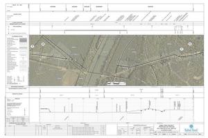
Update 2016-10-10: Going beyond the ones named in FERC’s commence order, this blog post includes maps for ALL RIVER CROSSINGS IN ALL THREE STATES!
Update 2016-10-10: All 527 of Sabal Trail’s April 2016 alignment maps are now available in small, big, huge, and PDF formats, courtesy of Lowndes Area Knowledge Exchange (LAKE): follow this link to the LAKE website.
Nevermind that
historic 128 to 34 Georgia House vote against river-drilling easements.
 The Georgia Attorney General’s office declined to defend lawsuits in
county Superior Courts (including Lowndes County, GA), and judges gave Sabal Trail the easements.
Then the U.S. Army Corps of Engineers issued its permit.
So Thursday John Peconom of FERC told Sabal Trail to start drilling under
Georgia’s Chattahoochee,
Flint, Ochlockonee, and
Withlacoochee Rivers,
as well as
Hannahatchee Creek.
They avoided Okapilco Creek by Continue reading
The Georgia Attorney General’s office declined to defend lawsuits in
county Superior Courts (including Lowndes County, GA), and judges gave Sabal Trail the easements.
Then the U.S. Army Corps of Engineers issued its permit.
So Thursday John Peconom of FERC told Sabal Trail to start drilling under
Georgia’s Chattahoochee,
Flint, Ochlockonee, and
Withlacoochee Rivers,
as well as
Hannahatchee Creek.
They avoided Okapilco Creek by Continue reading
Update 2016-09-04: “We’re on for Monday morning! River excellent condition,” says expedition leader Phil Hubbard.
Update 2016-09-02: Delayed until 10AM Monday 5th September due to aftereffects of Hurricane Hermine.
Update 2016-09-01: Watching Tropical Storm Hermine.
More people want to go after the pictures and reports from a few weeks ago,
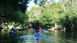 so WWALS has scheduled a redo from Roline to Cypress Creek on the iconic Suwannee River in north Florida.
Also with a slightly later start this time; more convenient for far-away folks.
so WWALS has scheduled a redo from Roline to Cypress Creek on the iconic Suwannee River in north Florida.
Also with a slightly later start this time; more convenient for far-away folks.
When: 10AM Saturday September 3rd 2016
Put in: Roline Launch, 30°33’51.0″N 82°43’30.6″W or 30.564185, -82.725167
Duration: 7.5 miles, about 4 hours.
Directions: Continue reading