Sabal Trail Georgia Section 401 Water Quality Permit

Received today from GA-EPD, although they issued it three weeks ago. Sabal-Trail-WQC-SAS16-Signed-Copy-0001 2013.0000000, 6.0000000 Basically, they believed Sabal Trail, with a few requirements, and issued the permit.

GA-EPD sent three documents, which are inline below with links to the PDF copies that were attached: Continue reading

Management update public hearing, Suwannee River State Park 2016-07-26

Received today from FDEP:

Recreation and Parks Public Hearing

CONTACT: DEP Press Office, 850.245.2112, DEPNews@dep.state.fl.us

DEP’s Florida Park Service is in the process of updating the Unit Management Plan for Suwannee River State Park. Citizens are invited to attend a public hearing to learn more about the proposed plans for the state park and to provide their comments.

Please review the public notice, agenda and draft plan. Copies may also be obtained by emailing Craig.Liney@dep.state.fl.us or calling 386-362-2746. The public is invited to review and submit comments to the Division of Recreation and Parks at FL_StateParkPlanning@dep.state.fl.us until Aug. 10, 2016.

WHAT: Public Hearing

WHEN: July 26, 2016
5-8 p.m.

WHERE: Suwannee River Water Management District Complex
9225 County Road 49
Live Oak, FL 32060

Continue reading

SRWMD listens about Sabal Trail easements, chooses unfortunately, yet offers assistance 2016-07-12

Attached are my comments to the SRWMD Governing Board today (July 12th 2016) in regards to the Sabal Trail crossing site over the Falmouth Cathedral Cave System.

I was the first to speak at the public comment period followed by Jim Tatum then Merrillee. Jim and Merrillee echoed my concerns. The three of us set the tone for the meeting! The Board was interested and engaged asking questions to better understand what impacts Sabal Trail poses for the cave system and the District. About Time!


Merrillee Malwitz-Jipson of Sierra Club Florida speaking to SRWMD 2016-07-12
Photo credit: Our Santa Fe River

Executive Director, Noah Valenstein offered to personally call the ACE to request Continue reading

Sabal Trail easements at SRWMD 2016-07-12 and SFWMD 2016-07-14

Tomorrow this morning (Thursday July 14th 2016) Sabal Trail is on the agenda of the South Florida Water Management District (SFWMD) for permission to use conservation easements Sierra Club facebook event
for its fracked methane pipeline. How does this square with Sabal Trail’s assertions that it already has all the permits it needs? The irony of meeting for this in West Palm Beach, a stone’s throw from four already-approved LNG export operations at the end of the Sabal Trail pipeline chain in Martin County. How does profit for a pipeline company from Houston and LNG export to Asia square with the mission of the Florida Department of Environmental Protection? If you’re in the area, please write, call, or go, before or by 9AM tomorrow morning to oppose these easements and put a kink in Sabal Trail’s pipeline. Continue reading

Road Closures in 2009 Flood, Lowndes County, GA

Back in 2009, Lowndes County spent hundreds of times more in infrastructure repairs than the $40,000 that Valdosta is asking as a match to build an online flood warning map, beyond just fixing sewer system spills to dealing with the rest of the flooding problem. Map of roads closed At recent meetings, some County Commissioners seemed reluctant to authorize the request because the proposed map mostly covers subdivisions in Valdosta. But the entire county was affected by road closures in 2009, so maybe Commissioners could ask to expand the map to cover the whole county, which could also help find sources of the flooding problem. Sources and effects extend all the way to the edges of the county, as you can see in this a google map I built back then:

Roads closed in Lowndes County, Georgia, as of 9:38 a.m April 6th, according to the Valdosta Daily Times. This map shows locations and terrain. It’s a Google map, so it’s interactive: you can zoom and pan and change to satellite view, street map, street view, etc. Some of the locations are guesstimates from the cryptic descriptions in the VDT article. The one green blob is the one reopening mentioned in the article: “North Valdosta Road Withlacoochee River Bridge opened at 10 p.m. Sunday.”

That VDT article no longer seems to be online, but this one is. Jason Schaefer, VDT, 27 April 2013, What natural events cost Lowndes taxpayers, Continue reading

Today: WWALS annual and board meetings, IHOP, Adel, GA 2016-07-13

This evening in Adel, come to the IHOP for the annual report and election of (some) board members at the WWALS membership meeting, and the annual election of officers and other business at the quarterly board meeting. 300x376 WWALS Rivers (small), in WWALS Rivers, by John S. Quarterman, for WWALS.net, 25 July 2015

When: 7PM WWALS Annual Meeting
7:30 PM WWALS Quarterly Board Meeting

Where: 1200 W 4Th St, Adel, GA 31620-2911
Here’s the IHOP’s own web page.

Agendas: See previous post

What: From the July 2016 Tannin Times, the WWALS membership newsletter: Continue reading

Pictures, Ribbon Cutting, Withlacoochee Water Pollution Control Plant 2016-07-12

The crowd was large, the speeches were brief, the food was good, and the tour later was, ah, redolant, but the new plant works better than the old, and, best of all, it’s out of the flood plain.

Sementha Mathews directs them all

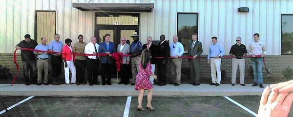
Here are a few pictures of this morning’s ribbon cutting for what was billed as the new Withlacoochee Wastewater Treatment Plant (WWTP) and Force Main, but they seem to have actually named the Withlacoochee Water Pollution Control Plant (WWPCP). The combination of WWPCP and Force Main so far has prevented any new wastewater spills, and long may it do so.

WWALS Videos will follow, including from a WWPCP tour by the plant operator.

Meanwhile, congratulations Continue reading