
David Bosch on water flowing southeast underground in the Floridan Aquifer


This Saturday, day after tomorrow, is the Withlacoochee and Little River Workshop
at VSU!
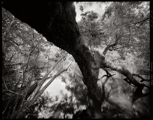 Art exhibit and auction organizer Julie Bowland sent these pictures by Bryan Garris, saying:
I will have an assortment of painting sizes on easels. I’m thinking there will be around 20 easel works and a table full of matted photographs. There will be a minimum bid set by individual artists, with 20% going to WWALS.
You can also bring your own artwork or objects to donate to WWALS for auction. See you there! Continue reading
Received today.
URGENT! — CALLS NEEDED TO STOP FRACKING BILL — SB 318

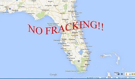
The fracking bill—SB 318—is scheduled for a vote in the Senate Appropriation Committee this Thursday, February 25.
We expect a close vote and need your help to stop the bill in this Committee.
If your State Senator is one of the 19 members of the Senate Appropriations Committee on the list below, please call him/her on now. Say that you live in the Senator’s district, and that you vote. Continue reading
Commissioners from counties on both sides of the Suwannee River saw the sinkholes and big oaks and pines directly above and near where
 Sabal Trail proposes to bore under Suwannee River State Park and the River,
led by WWALS board member and Hamilton County resident Chris Mericle,
assisted by Debra Johnson of SpectraBusters, Merrillee Malwitz-Jipson of Our Santa Fe River (OSFR), and others from as far away as south Florida.
All but one of the Suwannee County Commissioners were there, and he had a good excuse.
They also saw Falmouth Spring, which is part of a cave system which Sabal Trail claims is 100 feet deep. Both county commissions meet Tuesday March 1st; see below for details.
WWALS videos
Sabal Trail proposes to bore under Suwannee River State Park and the River,
led by WWALS board member and Hamilton County resident Chris Mericle,
assisted by Debra Johnson of SpectraBusters, Merrillee Malwitz-Jipson of Our Santa Fe River (OSFR), and others from as far away as south Florida.
All but one of the Suwannee County Commissioners were there, and he had a good excuse.
They also saw Falmouth Spring, which is part of a cave system which Sabal Trail claims is 100 feet deep. Both county commissions meet Tuesday March 1st; see below for details.
WWALS videos to come now posted.
You can see Continue reading
Update 2020-01-25: Superseded by WWALS Suwannee River Basin Map and All Landings in the Suwannee River Basin, now that Suwannee Riverkeeper territory includes the entire Basin plus Estuary, since Waterkeeper Alliance agreed to add the Ichetucknee and Santa Fe Rivers on September 26, 2019.
Update 2017-10-30:
River flowlines.
Update 2017-10-08:
Better colors plus a Suwannee River Basin map.
Update 2017-04-13: Since December 2016 WWALS Watersheds have included the Lower Suwannee River HUC 03110205
and the Suwannee River Estuary, approved by Waterkeeper Alliance the same time as the license for Suwannee RIVERKEEPER®.


Click on this link for an interactive google map of WWALS watersheds.
The images you see here are static screenshots of that google map. Follow the link above for the actual google map.
The watershed outlines are from Continue reading
You never know on our blackwater rivers in south Georgia and north Florida. The danger! The thrill of the rapids!
 OK, it was actually more like paddling on a lake with a current.
The hardest part was when the wind picked up against us a few times.
Sometimes we heard what sounded like rapids, but it was just flotsam lodged against oak trees.
OK, it was actually more like paddling on a lake with a current.
The hardest part was when the wind picked up against us a few times.
Sometimes we heard what sounded like rapids, but it was just flotsam lodged against oak trees.
But that’s the point: you really never know until you’re on the water, and on a trip like this with no good takeout until the end of the 18.25 miles, being prepared it much better than not.
The current did make for Continue reading
 Sabal Trail proposes to cross this sinkhole riddled landscape located next to Suwannee River State Park.
Chris Mericle
Sabal Trail proposes to cross this sinkhole riddled landscape located next to Suwannee River State Park.
Chris Mericle 
More pictures of the Long Alapaha River Paddle from GA 135 to GA 168. It actually took only 6 hours.
-jsq
You can join this fun and work by becoming a WWALS member today!

More pictures of the Long Alapaha River Paddle from GA 135 to GA 168. It actually took only 6 hours.
-jsq
You can join this fun and work by becoming a WWALS member today!