Tag Archives: flood

River Gage Projections for Hurricane Irma 2017-09-10

Update 2017-09-15: On the seventh day.

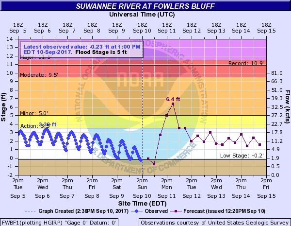
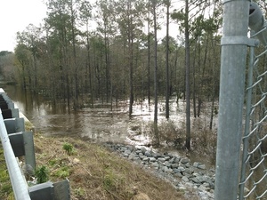
Hurricane Irma is bringing flood levels on on most of the rivers in the Suwannee River Basin. Here are the gages with projections from downstream to upstream, since Irma is coming from the south. The images here are static to show this moment, but click on any image to go through to the live gage.

Suwannee River

Suwannee River at Fowlers Bluff

Suwannee River at Fowlers Bluff

Suwannee River at Branford @ US 27

Continue reading

Bradford County, FL Comprehensive Plan 2012-04-19

Apparently you can mine almost anywhere in Bradford County, Florida, according to the Bradford County Comprehensive Plan:

Illustration A-X Bradford County MINING AREAS

That map is about as bad as the one in Continue reading

Videos: Coal Plant Public Hearing in Albany, GA 2017-05-04

You can still comment by tomorrow, Monday, May 8, 2017 on Georgia Power’s NIMBY plan for the coal ash it generated, to send it away from Plant Mitchell to local landfills, maybe yours.

Here are WWALS videos of the GA-EPD public hearing Thursday May 4, 2017 in Albany, GA, which we attended at the invitation of our neighbor Flint Riverkeeper Gordon Rogers, who said at the hearing he is lawyered up, and his attorney Chris Bowers of SELC also spoke.

Comment

You don’t have to hire an attorney; you can send in written comments by tomorrow, May 8, 2017, according to the the GA-EPD announcement of March 31, 2017: Continue reading

Coal Plant Public Hearing in Albany, GA 2017-05-04

Our neighbor Flint Riverkeeper Gordon Rogers requests people to come to Albany, GA for a coal ash public hearing. If you can’t go, please send in comments.

When: 7PM, Thursday, May 4, 2017

Where: Albany Technical College
Kirkland Conference Center
1704 S. Slappey Blvd.
Albany, GA 31701

What: Public Hearing about draft
National Pollutant Discharge Elimination System (NPDES) permit
for Georgia Power Company’s Plant Mitchell.

Why: It’s about coal ash.


Plant Mitchell (Georgia Power Co.) near Albany, GA 7/14/94. Photo courtesy of USGS. T.W. Hale, in Pamela P. Holliday, Sherpa Guides, unknown date, The Albany Levee: Trying to Tame the Flint.

Georgia Power proposed Continue reading

Okapilco Creek flooding @ GA 122 2017-01-23

Narrow Bridge 30.9955325, -83.6041529 Half a mile wide: Okapilco Creek one week ago on GA 122 between Barney and Pavo, Georgia.

Usually you have to peer down into the woods to see if you can see any water in the creek. After the recent storms, you could see water beside the highway half a mile before you got to the creek bridge.

WWALS video: Continue reading

Small Valdosta sewer spills after big rains 2017-01-23

Update 2017-01-25: And also a spill at the WWTP.

Nobody likes sewer spills, but no, these are not the same as before Valdosta’s recent wastewater system improvements: Document-0001 nothing this time came from the Withlacoochee Wastewater Treatment Plant, and the amounts were small compared to previous years (10-62%) and in far fewer locations.

That didn’t stop WTXL from using this title: Amber Lewis, WTXL, 24 January 2017, Major Sewage Spill Reported in Valdosta,

The City of Valdosta has reported that a large amount of untreated sewage has spilled in the area.

The Florida Department of Health reports that Continue reading

Lowndes County to match Valdosta funding for LiDAR flood mapping? 2016-07-11

Valdosta already had an airplane fly over Lowndes County and collect Light Detection and Ranging (LiDAR) data for flood mapping. Will Lowndes County step up and match Valdosta on this project that affects everybody in the county (and downstream into Florida)? Valdosta started this LiDAR project in March 2015, and Valdosta fronted the entire cost to get it done, we know because Valdosta Assistant Director of Utilities Emily Davenport and Valdosta City Council Tim Carroll told us at a meeting Valdosta held at the request of WWALS for interested parties downstream in Florida and from as far away as Atlanta.

On the agenda for the 8:30 AM Monday morning Lowndes County Commission Work Session, item 7.d. Continue reading

Skipper Bridge, 17.66 feet, flood level 15 feet

The water level continued up from yesterday, when it was Downstream 31.0116939, -83.2915878 17.66 feet on the USGS guage at Skipper Bridge in Lowndes County, Georgia at 9:46 AM when I took these pictures. Flood stage is 15 feet. It was so high you could have floated over the chain link fence the county put in when it replaced the bridge, thus preventing normal use of this bridge as a Withlacoochee River access point on the Withlacoochee and Little River Water Trail.

-jsq

You can join this fun and work by becoming a WWALS member today!

Downstream panorama 30.9016667, 83.2930556

Continue reading

Withlacoochee River at GA 122

This is a panorama; click on it to see the full picture.

See also Withlacoochee and Little River Water Trail and the pictures I took at Skipper Bridge a few minutes later. There’s a guage at Skipper Bridge, which read 17.66 feet, well above flood level.

-jsq

You can join this fun and work by becoming a WWALS member today!

Sea level gage reports: all USGS gages in WWALS territory in Georgia

All the Suwannee River Basin USGS gages in Georgia just got a new flood level reporting system (except they missed one). Locator Map: Central South Georgia USGS Gages They’ve added a level measurement from sea level, probably not coincidentally about the same as the Florida gages added a level measurement from dry riverbed, so both Georgia and Florida gages now have both measurements. This actually does not affect the WWALS level charts for the Withlacoochee and Little River Water Trail nor for the Alapaha River Water Trail, because those continue to display water levels from dry riverbed. To see this change at all, you have to drill down to the USGS detail pages, for example on the Withlacoochee River at Skipper Bridge Road in Georgia, or near Pinetta, Florida.

National Weather Service Weather Forecast Office, Tallahassee, FL, unknown date, Suwannee River Basin Datum Changes in South Central Georgia,

Starting on October 14, 2015, the National Weather Service in Tallahassee and Jacksonville will make adjustments to the reporting method for water level in the Suwannee River System. This includes river gages in the following rivers or creeks: Continue reading