Tag Archives: John S. Quarterman

WWALS moves to intervene with FERC about Sabal Trail pipeline

This legal action should reserve the right of WWALS to participate in legal hearings, file briefs on legal actions by others, or even to bring legal action. In addition to all the county and city resolutions listed here, Hamilton County, Florida also just moved to intervene.

Filed with FERC 16 December 2014 as Accession Number: 20141216-5051, “Motion to intervene and request for extension of filing deadline, by WWALS Watershed Coalition, Inc. under CP15-17.” Continue reading

1970s Canoe Trail FAQ

The rivers may be the same, but technology and the cast of characters have changed, as indicated by this Frequently Asked Questions (FAQ) list from the 1970s. The acronym FAQ hadn’t been invented yet, for that matter.

This Canoe Trail FAQ is courtesy of John Leonard, Executive Director of the Southe Georgia Regional Commission (SGRC). I’ve added some links and clarifications.

QUESTIONS YOU MAY HAVE CONCERNING THE CANOE TRAILS

  1. 300x388 One typewritten page, in 1970s Canoe Trail FAQ, by John S. Quarterman, for WWALS.net, 0  1979 Days to float entire trail (Alapaha) 4 days-normal water; (Withlacoochee) 3 days-normal water.

    That’s for the 83 miles of the 1970s Alapaha Canoe Trail brochures, and the 65 miles of the 1970s Canoe Guide to the Withlacoochee River Trail brochures. Those distances are shorter than the current Continue reading

Not in our county, state, or aquifer: Valdosta votes against Sabal Trail pipeline tonight

Tonight at 5:30 PM the Valdosta City Council will vote on a resolution against the Sabal Trail pipeline they discussed Tuesday at their Work Session. Valdosta added a clause about the Floridan Aquifer to the clauses already in the resolution Lowndes County passed Tuesday evening that Valdosta is supporting. Valdosta’s aquifer clause reads:

WHEREAS, the City of Valdosta has concerns regarding any potential effect the proposed pipeline or its construction might have on the Floridan aquifer, the primary source of the drinking water supply for our City, County and the south Georgia area; and

As VSU Prof. Don Thieme remarked yesterday, Continue reading

Alapaha River access at Riverside Church

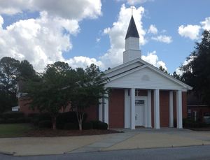
300x229 Riverside Church, in Alapaha River access at Riverside Church, by Bret Wagenhorst, 14 September 2014 Nine miles south of Willacoochee on GA 135 and twelve miles east of Nashville on GA 76, which turns into Riverside Road as it crosses GA 135, is this traditional put-in for the Alapaha River. However, it is not clear that access is public, so we can’t recommend it unless that is clarified. Continue reading

Canoeing Guide to the Withlacoochee River c. 1979

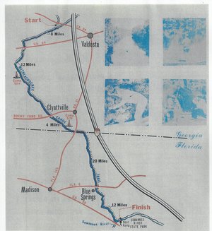
300x327 Map, in Canoe Guide to the Withlacoochee River Trail, by John S. Quarterman, for WWALS.net, 0  1979 Including both Florida and Georgia, a second river got map and guide attention back in the 1970s. To be updated in the Withlacoochee River Water Trail.

This Withlacoochee River guide is courtesy of John Leonard, Executive Director of the Southern Georgia Regional Commission (SGRC).


I would speculate that it is the most recent of the three guides posted thus far, because the Continue reading

Alapaha River rainy season?

Veteran boater Bret Wagenhorst asked:

300x214 Alapaha, GA 02316000, in Alapaha River gauge heights over time, by John S. Quarterman, for WWALS.net, 1 December 2014 Is there a defined “rainy season” on the Alapaha? I have seen the water high in December, March, July, and once even in September.

Good question!

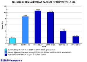
300x214 Irwinville, GA 02315920, in Alapaha River gauge heights over time, by John S. Quarterman, for WWALS.net, 1 December 2014 Looking at the record high water levels for the gauges, they’re all in April, March, February, or January.

Also, the only January one is for Irwinville, the farthest upstream, which also had its highest ever in February with that January high only slightly lower.

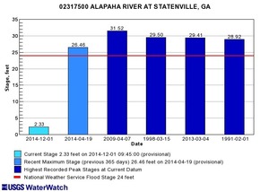
300x214 Statenville, GA 02317500, in Alapaha River gauge heights over time, by John S. Quarterman, for WWALS.net, 1 December 2014 Downstream, Continue reading

Canoeing Guide to the Alapaha River c. 1979

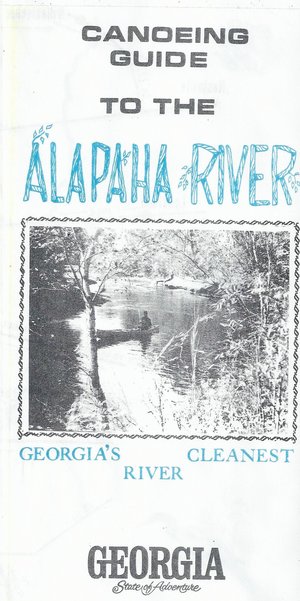
300x601 Cover: Georgias Cleanest River, in Canoeing Guide to the Alapaha River, by John S. Quarterman, for WWALS.net, 0  1979 Here’s a different guide to the Alapaha River from the one WWALS previously received; this one is courtesy of John Leonard, Executive Director of the Southern Georgia Regional Commission (SGRC). The Alapaha River Water Trail WWALS is currently developing is merely a continuation of this more than three decade old Alapaha Canoe Trail.

John Leonard said that when he started at the predecessor of the SGRC in 1980, calls came in frequently asking about water levels on the Alapaha River. It took him a while to realize why: the Alapaha River Trail had been written up in Southern Living! He did not have Continue reading

TDC Letter of support for Alapaha River Water Trail from Hamilton County, FL

300x225 Alapaha River Water Trail Committee Chair Chris Graham, Chris Mericle, TDC  check, WWALS president John S. Quarterman 2014-10-26, in TDC support letter for Alapaha River Water Trail, by Gretchen Quarterman, for WWALS.net, 19 November 2014 First a $250 check, then a letter of support, from the Hamilton County, Florida Tourist Development Council (TDC). WWALS thanks TDC!

In this picture taken at the 26 October 2014 Dead River Sink Outing Continue reading

Sabal Trail on GWC Dirty Dozen: contamination, sinkholes, aquifer –WCTV

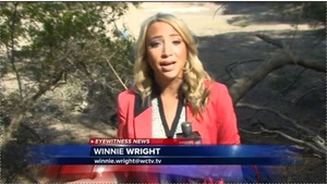
WCTV’s Winnie Wright interviewed VSU’s Don Thieme, and VSU’s Can Denizman navigated her to the the Cherry Creek sinkhole site for part of her report about 300x169 Sinkhole opened suddenly --Winnie Wright, in GWC Dirty Dozen Sabal Trail on WCTV, by John S. Quarterman, for WWALS.net, 26 November 2014 the Withlacoochee River in Georgia Water Coalition Dirty Dozen 2014 Item 9 as threatened by the Sabal Trail pipeline. Sabal Trail’s Andrea Grover is “disappointed” in being on the Dirty Dozen; does she also find it “hard to believe” like Sabal Trail’s well-documented eminent domain threats?

Winnie Wright, WCTV, 26 November 2014, Sabal Trail Pipeline Environmental Concerns Cited In Annual ‘Dirty Dozen’ Report, Continue reading

Organizational Meeting for Alapaha River Water Trail 2014-12-13

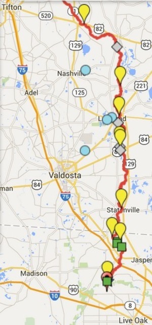
300x638 ARWT, in Alapaha River Water Trail draft map, by John S. Quarterman, for WWALS.net, 7 November 2014 WWALS Watershed Coalition, Inc.
a 501(c)(3) nonprofit corporation
3338 Country Club Road #L336
Valdosta, GA 31605
17 November 2014

Re: Alapaha River Water Trail

Dear Neighbor,

You are invited to an organizational meeting for the Alapaha River Water Trail by WWALS Watershed Coalition (WWALS). This updates and slightly extends the old Alapaha Canoe Trail from the 1970s, with new map, brochure, and website in the making.

When: 1-4PM Saturday December 13th 2014
Where: Continue reading