Tag Archives: Nashville

Old Coffee Road, Georgia

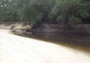
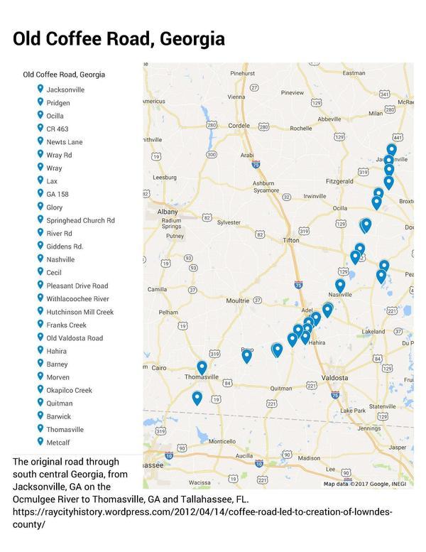
The Google map of locations on Old Coffee Road was used by many of the early settlers of south central Georgia, including in the watersheds of the Willacoochee, Alapaha, Withlacoochee, and Little Rivers and Okapilco Creek. It crossed all those and other waterways by ford or private ferry: there were no bridges back then.

Old Coffee Road map, WWALS.net
Follow this link for the interactive google map.

The Georgia Historical Commission erected markers at half a dozen locations in the 1950s and 1960, reading: Continue reading

Old Coffee Road across Alapaha River

Many of you know Julian Fields, retired forester, very knowledgable about many things around south Georgia. In this video, he’s showing people where Old Coffee Road forded the Alapaha River. I haven’t been able to find a map of any age that shows that ford. However, given that Old Coffee Road in Berrien County goes as far as Rowetown Church Road, I’d guess either Rowetown Church Road is where Old Coffee Road crossed the river, at Rowetown Church Cemetery, or it was somewhat upstream. Does anybody know?

Julian Fields

Or I suppose I could just ask Julian. Here’s the video: Continue reading

Berrien Beach Landing (GA 168) to Lakeland (GA 122), WWALS Outing 2017-02-11

12 + 4 boats and about 18 paddlers went even faster down the Alapaha River than we expected: six hours on the water between GA 168 and GA 122, including a lunch stop. That’s about 3 miles per hour on a chilly morning and a fine breezy warm day. And there were bon-bons and kumquats!

WWALS banner by Gretchen Quarterman
WWALS banner at lunch stop; picture by Gretchen Quarterman for WWALS.

Lots of native vegetation, no invasive species, some birds (buzzards, ducks, heron, flycatcher, cardinals), no animals on the land or in the water. People fishing at Lakeland said they didn’t even get a nibble. I did see a few fish beds below a creek confluence.

The water level was Continue reading

GA 168 (Berrien Beach) to GA 122 (Lakeland) Alapaha River Outing 2017-02-11

Long, but if the water is high, should be fast: 16 1/2 miles from Berrien Beach Landing to Lakeland Boat Ramp on the lovely wild Alapaha River Water Trail. As long as the rains keep coming, the river should be high and it should take less time than the usual estimate of eight hours. Bring the usual personal flotation device, boat paddles, food, drinking water, warm clothes, and first aid kit. There is no good place to take out before the end point, so be prepared to paddle all day.

When: 7:00AM, Saturday, February 11th, 2017

Put In: Berrien Beach Ramp, on GA 168 east of Nashville, Berrien County, Georgia, at 31.159076, -83.045554. Continue reading

Suwannee-Satilla Regional Water Planning Council meeting, Nashville, GA 2016-03-09

Received today this NOTICE, SUWANNEE-SATILLA REGIONAL WATER PLANNING COUNCIL MEETING, Announcement Date: February 16, 2016, TO ALL INTERESTED PERSONS AND PARTIES::

The Suwannee-Satilla Regional Water Planning Council is holding its next meeting for the Review and Revision of the Suwannee-Satilla Regional Water Plan at the following date, time, and location:

Wednesday, March 9, 2016
Registration: 9:00 A.M. – 9:30 A.M.
Meeting: 9:30 A.M. – 4:00 P.M.

Nashville Community Center Continue reading

Boating with Gwyneth on Lake Lewis and the Alapaha River 2015-05-25

Update 2015-05-17: Upcoming events.

Memorial Day Monday, Gwyneth Moody of Georgia River Network will be down from Athens to see some sights on the Alapaha River Water Trail (ARWT). You are invited to boat among the birds at 9AM on Lake Lewis with WWALS and Gwyneth, to discuss the ARWT over lunch at Puerta vel Sol in Nashville, GA, and then to paddle upstream on the Alapaha River from Berrien Beach at GA 168. Continue reading

Alapaha River @ GA 135, Berrien County south of Willacoochee

Update 2020-09-07: This location is now known as Nashville Landing.

300x210 There is a long sandy beach upstream from the bridge, which is a popular summer hangout for locals., in GA 135 Alapaha River access, by Bret Wagenhorst, for WWALS.net, 14 September 2014 There is a long sandy beach upstream from the bridge, which is a popular summer hangout for locals.

Bret Wagenhorst took these pictures 14 September 2014.

See also Alapaha River Water Trail. Continue reading

Alapaha River access at Riverside Church

300x229 Riverside Church, in Alapaha River access at Riverside Church, by Bret Wagenhorst, 14 September 2014 Nine miles south of Willacoochee on GA 135 and twelve miles east of Nashville on GA 76, which turns into Riverside Road as it crosses GA 135, is this traditional put-in for the Alapaha River. However, it is not clear that access is public, so we can’t recommend it unless that is clarified. Continue reading

Outing at Avera’s Mill Pond (Lewis Lake)

Lewis Lake, site of today’s outing at 4PM, is Avera’s Mill Pond. According to Wenda Gaile Bailey, “there was a partial draining of the lake late last year”, but she checked the water level yesterday. Here’s some history, and some pictures from five years ago of what you may see today.

WG Bailey wrote for WG Bailey photos, unknown date, Old Fashioned Pond Draining at Lake Lewis,

Avera’s Mill Pond, the oldest and largest pond in Berrien County, was founded by William M. Avera, son of pioneer, Daniel Avera, covers 1470 acres, and was built in the 1870’s at a cost of $3800.87

The mill dam is located Continue reading