Where does the buck stop for these “routinely anticipated budget shortfalls”? Who let a budget include those? Isn’t the point of a budget to, well, budget for what’s needed? Or, given the history of deliberate downsizing of environmental agencies in Florida, maybe shortfalls were the point.

Noah Valenstein got the job as secretary of the Department of
Environmental Protection on Tuesday May 23rd, on a unanimous vote by
Gov. Rick Scott and the Cabinet. His previous job? Executive
director of the Suwannee River Water Management District, which was
flagged by state auditors for $22.5 million in “questionable costs”.
The audit covered the time Valenstein led the district. He oversees
the district in his new job.
[Special to the Times]
Mary Ellen Klas, Miami Herald-Times Tallahassee Bureau, 14 July 2017, Auditors find millions in ‘questionable costs’ at water district,
Weak budgetary controls led to $22.5 million in “questionable costs,” auditors found. Officials had transferred $13.3 million of it into the district’s operating account without proper authority. They may have overspent some areas of the budget and directed money to other areas to make up for shortfalls. They set aside $3.8 million “in the event of an economic crisis” without authorization, and they steered $1.7 million “to cover routinely anticipated budget shortfalls” without explanation.
Contingency funds, sure, but “routinely anticipated”? And in an economic crisis, wouldn’t it be the legislature that should be authorizing funds?
Auditors concluded that accounts were “misclassified because district personnel misunderstood” standard accounting requirements and budget staff members were “somewhat new to the process” so they couldn’t explain how and why it happened.
That is what happens when a state massively defunds its environmental agencies and makes political tests and servicing economic development more important than competence. The article goes into that, rightly pointing a finger repeatedly at Governor Rick Scott, who said “ensuring that Florida’s precious water resources are protected and managed in the most fiscally responsible way possible” while:
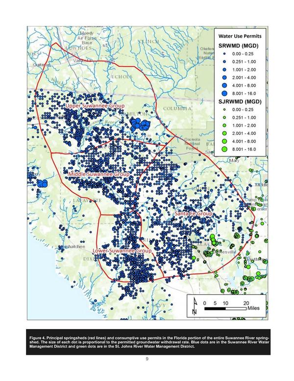
The five districts, whose boards are appointed by the governor and operate under the oversight of the Department of Environmental Protection, were purged of hundreds of veteran professionals, and budgets were cut in half. They continued cutting their budgets through 2016. Suwannee, because of its small size, had proportionally fewer cuts.
The article discusses and quotes SRWMD staff, with some pretty amusing tidbits, including this one from “Roary E. Snider, the district’s chief of staff”, who
also disputed the auditor’s claim they don’t have documentation. “While we absolutely will provide these records, these documents were largely in hard copy,” Snider said. “Staff couldn’t assemble these additional records in time.”
SRWMD staff don’t know how to use a scanner? Or they didn’t know where they put those paper documents? Or maybe the dog ate them.
The article even quotes Eric Draper of Audubon Florida about “problems we’ve seen at the Suwannee River district with the change of leadership over the years,”. If Audubon Florida “works closely with the water management districts”, what did Audubon Florida know, when did they know it, and why are they only speaking up now?
The actual audit report lists on page 2:
Executive Director
Noah Valenstein from October 13, 2015
Carlos Herd, Interim, from May 14, 2015, to October 12, 2015
Dr. Ann B. Shortelle to May 13, 2015
The article mentions that:
The district is overseen by the Florida Department of Environmental Protection, which is now headed by Noah Valenstein. His last job was executive director of the Suwannee River WMD during the time the audit was underway.
Guess which fox the foxhouse is turning to for assistance:
The district said it would turn to the Department of Environmental Protection for advice on how to resolve the dispute over whether money is owed to the state.
“DEP has communicated with staff at the Suwannee River Water Management District, and they have informed us that they are reviewing accounting and land acquisition records for additional information,” said Lauren Engel, spokesperson for Valenstein.
“If it is determined that these funds should be returned to DEP, they would go to the trust fund from which the funding was issued, however, DEP would require spending authority from the legislature to use it.”
This is the same Noah Valenstein who told me shortly after he was appointed to SRWMD that he believes that Florida law requires him and SRWMD to provide water resources for economic development. Maybe he should have paid more attention to making sure the economic resources of the District were properly organized.
The Miami Times-Herald story as carried by tbo.com (Tampa Bay Times) has a bit more pointed headline and picture caption (see top of this blog post), Auditors find millions in ‘questionable costs’ at water district, but will it matter? Continue reading