
 Calls from Atlanta and from downstream in Florida about the
three Valdosta wastewater overflows in February prompted WWALS as the local watershed organization to contact
the City of Valdosta about organizing a presentation to the interested parties.
Valdosta presented less than two weeks later, and brought their entire hierarchy related to this issue, from the mayor on down. Plus Lowndes County, which isn’t even responsible for Valdosta’s wastewater, was represented by their Chairman and a Commissioner.
In
Valdosta’s slides and the LAKE videos of that meeting of Tuesday 17 March 2015,
you can see many questions were answered, but some are still open. Continue reading
Calls from Atlanta and from downstream in Florida about the
three Valdosta wastewater overflows in February prompted WWALS as the local watershed organization to contact
the City of Valdosta about organizing a presentation to the interested parties.
Valdosta presented less than two weeks later, and brought their entire hierarchy related to this issue, from the mayor on down. Plus Lowndes County, which isn’t even responsible for Valdosta’s wastewater, was represented by their Chairman and a Commissioner.
In
Valdosta’s slides and the LAKE videos of that meeting of Tuesday 17 March 2015,
you can see many questions were answered, but some are still open. Continue reading
Tag Archives: Suwannee River Water Management District
Sabal Trail ignored springs and underground connections –TSE Plantation
 A Suwannee County, Florida landowner points to
newly-discovered connections between springs under rivers
and to
other well-known springs
Sabal Trail ignored, adding:
A Suwannee County, Florida landowner points to
newly-discovered connections between springs under rivers
and to
other well-known springs
Sabal Trail ignored, adding:
Note that the undersigned is a lay person attorney and NOT a karst expert. Basic research revealed the information contained herein and the omission of this infonnation by Sabal’s purported karst experts should raise serious questions as to the credibility of Sabal’s filings.
Filed with FERC 29 January 2015 as Accession Number: 20150129-5192, “Supplemental Information / Request of Edwards & Ragatz, P.A. under CP15-17. Supplemental Comments of Proposed Intervener, Thomas S. Edwards, Manager, TSE Plantation, LLC Opposing Portion of Sabal Trail Route and Related Motion to Accept Late Comments”, Continue reading
Springs flow under the Suwannee River next to the Withlacoochee River (Falmouth Dye Trace)
 The Sabal Trail fracked methane pipeline route went through
this area, and the new route is only slightly to the north.
There are springs all over this area.
The same karst limestone underlies the Withlacoochee River
in Georgia, where the river already leaks into the aquifer north
of Valdosta.
A pipeline anywhere in the karst limestone containing the
Floridan Aquifer is a very bad idea.
Profit for Sabal Trail, FPL, or Spectra Energy is no excuse for
risking our drinking water.
The Sabal Trail fracked methane pipeline route went through
this area, and the new route is only slightly to the north.
There are springs all over this area.
The same karst limestone underlies the Withlacoochee River
in Georgia, where the river already leaks into the aquifer north
of Valdosta.
A pipeline anywhere in the karst limestone containing the
Floridan Aquifer is a very bad idea.
Profit for Sabal Trail, FPL, or Spectra Energy is no excuse for
risking our drinking water.
SRWMD PR 4 December 2014, Falmouth dye trace reveals unknown connectivity,
FOR IMMEDIATE RELEASE
LIVE OAK, FL, December 4, 2014 — The District and Florida Geological Survey introduced dye into Falmouth Spring On September 4th, in hopes of learning which other springs were connected to the known Falmouth Cathedral Cave System. Two days after the dye was release the dye appeared in two springs previously not known to be connected, Ellaville and Suwannacoochee.
Continue reading
Alapaha River water levels
Update 2025-09-21: Graphs from water.noaa.gov.
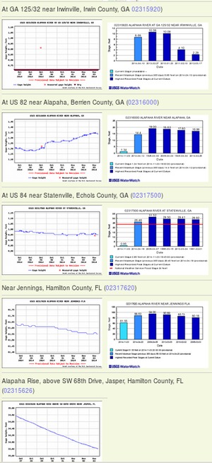 Update 2016-12-23: graphs from water.weather.gov.
Update 2016-05-31: See sea level gage reports.
Update 2015-04-28: Added flood stages and tentative highest safe and lowest boatable water levels, both above the charts for each gauge and in a summary table. If you have data, please let us know.
Here are water level gauges for the Alapaha River in Georgia and Florida, north to south. The graphs should show the current levels at this time, in feet, plus for most of the gauges a bar graph of selected historic levels.
This is a draft of a concept for use with the Alapaha River Water Trail. See also Alapaha River Rainy Season.
It is also a companion to the similar set of graphs for the Withlacoochee and Little Rivers.
See below for the current Alapaha River water level graphs. Continue reading
Dead River Sink, Alapaha River, WWALS Outing, 2PM 26 Oct 2014
This Sunday afternoon, Oct 26th at 2PM:
where the Dead River meets the Alapaha River and goes underground
at the Dead River Sink, aka the Alapaha Sink.
 Park on SRWMD’s Jennings Bluff Tract and walk in with WWALS
to see what Samuel Taylor Coleridge dreamed as
“Where Alph, the sacred river, ran
Through caverns measureless to man
Down to a sunless sea.”
No boat required: this is a walking outing.
Park on SRWMD’s Jennings Bluff Tract and walk in with WWALS
to see what Samuel Taylor Coleridge dreamed as
“Where Alph, the sacred river, ran
Through caverns measureless to man
Down to a sunless sea.”
No boat required: this is a walking outing.
It’s an adventure, as Deanna Mericle reported recently:
…the hike to the sink does have some steep parts, especially if you go the scenic route, which I recommend. The area around the sink itself is kind of steep with slick mud/clay. So wear good shoes for hiking. There were only a few Mosquitos. The area is beautiful and worth the effort.
This event is FREE! All we ask is Continue reading
Withlacoochee and Suwannee paddle: springs, shoals, and pipeline 21 Sept 2014
Update 20 September 2014: Now with a lunch stop at Chris and Deanna’s house! Bring your own lunch or snacks, but the Mericles have picnic tables and bathrooms. Chris reports the Withlacoochee is high enough that the shoals are no problem, and the weather report says clear all day tomorrow. See also his report on FERC and Sabal Trail’s recent visit to this same area and what Sabal Trail wrote to FERC the next day.
 Sabal Trail may be thinking of moving their pipeline, but WWALS is
still padding past the original location 10AM Sunday September 21st.
All are invited to come see for themselves the springs, shoals, and sinkholes
that we value more highly than pipeline profit for a company from Houston.
Join us for a fine day on two of our fabulous southern blackwater rivers:
the Withlacoochee River and the Suwannee River, in Hamilton and Suwannee
Counties, Florida.
Sabal Trail may be thinking of moving their pipeline, but WWALS is
still padding past the original location 10AM Sunday September 21st.
All are invited to come see for themselves the springs, shoals, and sinkholes
that we value more highly than pipeline profit for a company from Houston.
Join us for a fine day on two of our fabulous southern blackwater rivers:
the Withlacoochee River and the Suwannee River, in Hamilton and Suwannee
Counties, Florida.
The meeting place is the CR 143 Boat Ramp on the Withlacoochee River near Jennings, Florida. For directions, please see the earlier post about this outing.
This event is FREE! All we ask is Continue reading