Tag Archives: Suwannee River

Hydrogeologic Issues of Concern, HDD under Suwannee River –Peter J. Schreuder 2016-06-23

See press release, New hydrology report exposes Sabal Trail pipeline risk to Floridan Aquifer, and this report is also available in PDF.

Hydrogeologic Issues of Concern

Schreuder, Inc. Water-Resources & Environmental Consultants

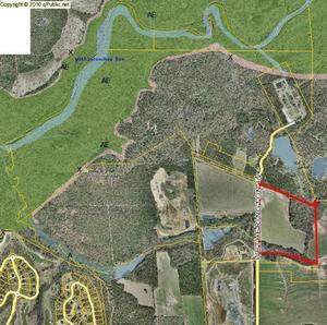
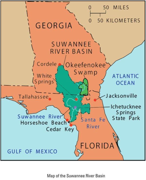
Directional Horizontal Drilling (HDD) under the
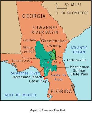
Suwannee River
At Suwannee River State Park

Hydrogeologic Issues of Concern

In any review of potential environmental consequences related to the use of Horizontal Directional Drilling (HDD), both the geotechnical and scientific communities can be expected to raise serious concerns when such drilling is done around karst areas, and in regions which over lie the Floridan Aquifer System (FAS), which includes the Upper Floridan Aquifer, and the karstic geologic subsurface features at the location proposed in Continue reading

Ribbon Cutting, new WWTP and Force Main 2016-07-12

Finally ready for prime time and a ribbon cutting: the new, uphill, out-of-the-floodplain, long-awaited Withlacoochee Wastewater Treatment Plant (WWTP) and Force Main, New WWTP site near Withlacoochee River which have not overflowed or otherwise caused sewage spills in the recent rains, so maybe Valdosta’s chronic problem smelt downstream all the way to the Gulf is perhaps finally fixed. Congratulations, Valdosta!

When: 8AM Tuesday July 12th 2016

Where: At the new WWTP on Wetherington Lane, north off US 84, west of I-75 exit 16

Invitations: Paper invitations were mailed last week, including to counties and health departments downstream in Florida, according to Sementha Mathews. If you didn’t get one, contact her, and she says the event is in any case open to the public.

Update 2016-05-30: Sementha Mathews says the paper invitations were mailed Tuesday (day before yesterday), so they should arrive by the end of the week. Arrived.

Contact: Sementha Mathews Continue reading

Push to block Sabal Trail gas pipeline looks to enlist U.S. Army Corps of Engineers –Florida Bulldog

Again tying Florida Governor Rick Scott into the Sabal Trail fracked methane pipeline invasion, Florida Bulldog reports about last month’s elected official hike at the Suwannee River, Pastured Life, Peurrung, Hildreth Compressor Station but could get no response from hike attendee Ted Yoho FL-03. And FL Bulldog confirmed that as of last week the Corps had not responded to Sanford Bishop GA-02.

Jake Galvin and Dan Christensen, Florida Bulldog, 28 June 2016, Push to block Sabal Trail gas pipeline looks to enlist U.S. Army Corps of Engineers, Continue reading

Pipeline Opposition Meeting in Gainesville, FL 2016-08-06

August 6th in Gainesville, you can join groups and individuals in Gainesville to defend water and property rights from the invading Sabal Trail fracked methane pipeline.

Third place: Jessica Bowman, Branford High School, 12 grade
Picture by Jessica Bowman, Branford High School, 12 grade, Third Place in Lime Run Sink Photography Contest organized by the Woman’s Club of Live Oak and WWALS Watershed Coalition.

You can register for the conference here, and soon we’ll hear the location and times of day. All of Florida and south Georgia drinks from the Floridan Aquifer, and the Suwannee, Santa Fe, and other rivers with their springs such as Lime Run (depicted here) are gems that also bring in substantial tourism revenue to Florida.

While Sabal Trail only aims at the southwest corner of Alachua County, Gainesville is near the center of the proposed pipeline path of destruction and hazard in Florida. WWALS will be there, and we welcome many new groups to the pipeline opposition which is water conservation and protection of property rights.

Below is what Johanna de Graffenreid of Gulf Restoration Network sent as background. I’ve added some pictures and some links for easy access. WWALS applauds Gulf Restoration Network for taking on the task of organizing this conference.

STOP THE SABAL TRAIL PIPELINE

Continue reading

Where to look for dye from Alapaha Dye test

Update 2023-05-01: Alapaha Swallets Dye Trace Project 2016-10-01.

Tom Greenhalgh dying the Dead River, Harley Means, and a drone Tom Greenhalgh started putting the dye in the Dead River Swallet about 11:06 this morning, with Harley Means observing in this picture, plus a drone also taking pictures. See below for where to look for the dye coming back up in the next few days. If you see it, please take a water sample for SRWMD. Continue reading

Dye test in Dead River Sink on Alapaha River

Update 2016-06-22: Dye test into the Dead River Sink: it came back up several days later and eighteen river miles south, in the Alapaha River Rise and Holton Bluff Spring, both on the Suwannee River.

The Alapaha River disappears underground in dry seasons, and nobody has ever known where it comes back up. Soon, we will know.

Green Publishing, 16 June 2016, Dye test held for river basins,

The Florida Geological Survey will be conducing a dye test for the Suwannee River Water Management District in the Upper Suwannee/Alapaha River basins later this month. They will introduce dye into the Dead River Swallet (swallets are sinkholes that capture flow) and a swallet that is located on privately owned land. They will also have sampling devices setup at Continue reading

Map of Suwannee River Basin

Map of Suwannee River Basin Yet another map, this one from the Suwannee River Basin and Estuary Integrated Science Workshop, USGS, 22-24 September 2004, Cedar Key, Florida, Compiled by Brian Katz and Ellen Raabe. Here are the slides from that workshop.

This map is a bit odd in that it does not show the biggest city in the entire Suwannee River Basin.

However, it shows nearby larger cities. I never really realized Jacksonville is closer than Tallahassee to most of the Basin.

Map of Suwannee River Basin

For more maps, see the WWALS Suwannee River Basin web page.

-jsq

You can join this fun and work by becoming a WWALS member today!

Sabal Trail reacts to Sanford Bishop GA-02, WWALS, Price P.G.

It’s time for more people and organizations, especially Congress members, to ask the Corps for a Supplemental Environmental Impact Statement, after Sabal Trail side-stepped many of the questions Cover letter in a 130-page claim that it had already addressed every recent point from U.S. Rep. Sanford Bishop GA-02, WWALS Watershed Coalition, Flint Riverkeeper, and Dennis Price P.G. in recent letters to the U.S. Army Corps of Engineers. If karst concerns alone were enough to move Sabal Trail off of the Withlacoochee River in Florida, and the Itchetucknee River, and to move it to a different crossing for the Santa Fe River, they should be enough to move it off the Suwannee River, where the conditions are quite similar.

In case anybody wondered whether Sabal Trail is watching the web for anything posted by its opponents, note where Sabal Trail said in its included 6 June 2016 letter to Mark R. Evans of the Corps that it first saw Sanford Bishop’s letter: Continue reading

Valdosta force main and new WWTP are online and working

The recent rains caused little wastewater overflow, according to Valdosta City Council Tim Carroll, who forwarded cryptic Valdosta press release yesterday and then explained on the telephone what it meant: Map the two biggest pieces of Valdosta’s wastewater and sewer fixes are operational already.

The press release referred to “the new force main” as if it were already in operation, yet nothing on Valdosta’s website says it is. So I called Tim Carroll and he confirmed that yes, the force main is online. Not only that, but 5 million gallons less water than usual for such rains entered the new Withlacoochee Wastewater Treatment Plant (WWTP).

Wait, does that mean the new, uphill, out-of-the-floodplain WWTP is also online? Yes, confirmed Carroll. And the less inflow was due to less INI.

What’s INI, I asked, ignorantly? Continue reading

Roline to Cypress Creek, Suwannee River, 2016-08-13

Join us for a summer morning paddle on the iconic Suwannee River in Florida.

Shuttle When: 8AM Saturday August 13th 2016

Put in: Roline Launch, 30°33’51.0″N 82°43’30.6″W or 30.564185, -82.725167

Directions: From Jasper: east on CR 6 approx. 15 miles, left on Woodpecker Rd. (Dirt) about 3 miles, follow sign to launch.

Take out: Cypress Creek South Launch

Duration: 7.5 miles, about 4 hours.

Events: facebook, meetup.

Shuttle: Continue reading