Tag Archives: testing

Valdosta water quality testing data 2018-09-12

Here is most of a year’s river water quality testing data from the city of Valdosta, on a Water Reporter map:

Valdosta stations, Map

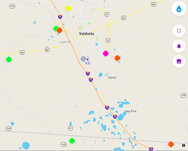
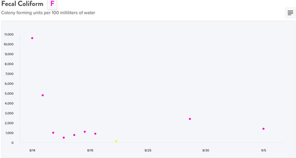
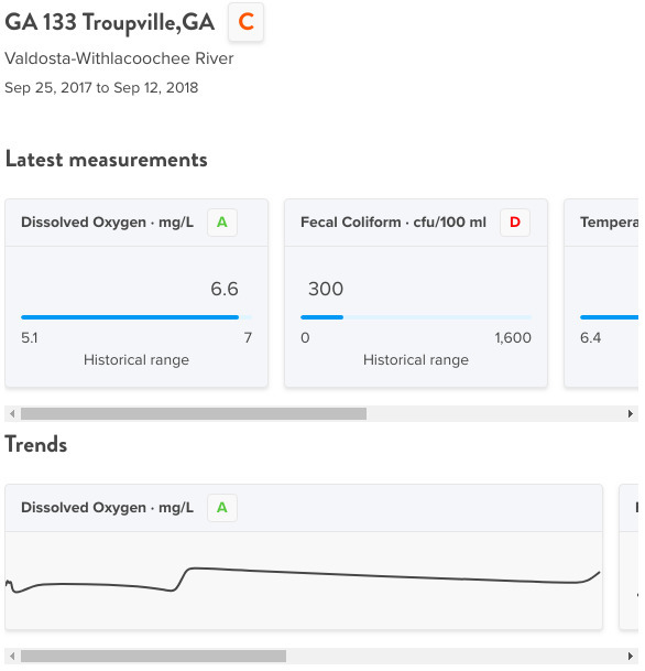
Click on any of the colored diamonds for graphs. Scroll right to see more graphs. Click on any graph to see every datapoint. Clearly fecal coliform (FCOLI) and E. coli (ECOLI) have significant spikes way beyond the Georgia state limit of 200 cfu/100 ml.

However, as we already saw on the spill followup data map, often, even usually, FCOLI and ECOLI are just as bad or worse upstream Continue reading
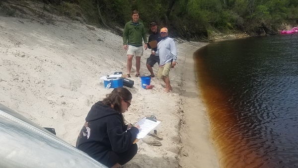
Followup water quality data after big Valdosta 2018 spills 2018-09-21

Here is (at least some of) the water quality testing data Valdosta was required to collect after its major spills of June in the Withlacoochee River basin and August in the Alapaha River basin. Maybe Valdosta is right that neither of these spills got into waterways, but something sure did, according to this data. Curiously, in both cases the worst fecal coliform readings were upstream from the spill location.

Mud Creek WTP after the 13 August 2018 spill

Below at Johnson Road, Mud Creek WTP
Downstream at Johnson Road on Mud Creek from the Mud Creek WTP after the August spill

There’s only one datapoint (the yellow dot) on that graph below the Georgia safe limit for fecal coliform of 200 colony forming units per 100 milliliters of water (cfu/100 ml). You’d think it would be better upstream, right? Continue reading

Stream Monitoring after Lowndes County Val-Tech Road Spill 2017-09-23

Here is Lowndes County’s (not Valdosta’s) stream monitoring data for a year after its September 23, 2017 raw sewage spill into a ditch that goes to the Withlacoochee River. The data show often worse water quality upstream than downstream. This is a good illustration of why WWALS is starting a water quality testing program.

Graphs, Below at GA 133

These graphs are in Water Reporter, where I put the data under the Suwannee Riverkeeper group. The first two graphs are from below the spill, downstream on the Withlacoochee River at GA 133 (St. Augustine Road).

Graphs, Below at GA 133

Fecal Coliform, Below at GA 133

The other graphs show nothing unusual for blackwater tannic acid rivers. This is the interesting graph, Continue reading

Training, Water Quality Testing, Pictures 2018-09-16

Update 2018-10-24: First test kit complete! Now waiting for analysis equipment to arrive. For more details on recent background, see Valdosta (and other) wastewater.

Thanks to Julie Shutters of Golden Triangle R&D for coming down from Sylvester to Valdosta, GA to do Georgia Adopt-A-Stream training for WWALS.

(No, we haven’t forgotten about Florida. We’re just starting with the biggest problem area.)

Class

[Julie Shutters, Ronnie Thomas, Erica McLelland, Shirley Kokidko, Joanne A. Wardell, Gretchen Quarterman, Bobby McKenzie, John S. Quarterman (hat)]
Julie Shutters, Ronnie Thomas, Erica McLelland, Shirley Kokidko, Joanne A. Wardell, Gretchen Quarterman, Bobby McKenzie, John S. Quarterman (hat)

Continue reading

Big Georgia Wastewater Permits in the Suwannee River Basin

Update 2021-03-18: Plus Moody Air Force Base.

Update 2021-03-17: Now with Ray City added 2021-03-15 and Lakeland added 2021-03-17.

Schedules of testing, with permissable levels: these are in National Pollutant Discharge Elimination System (NPDES) wastewater permits, so we need to see those permits. You’d think they’d be on the EPA or GA-EPD website, but….

The U.S. EPA has delegated NPDES permitting to Georgia. You can get draft wastewater permits right off the GA-EPD website, but to get the actual current approved permits, you must get GA-EPD to send them to you. I found this out from Audra Dickson, Wastewater Regulatory Program Manager. I asked her for permits for half a dozen cities and one county, and the next day Alyssa Thomson, Environmental Specialist, Wastewater Regulatory Program, Municipal Permitting Unit, sent them via email.

They’re on the WWALS website now.

Instream Monitoring Requirements, Valdosta Mud Creek WPCP

Why this list? Continue reading

Organizational meeting, WWALS Water Quality Testing Committee 2018-08-21

After years of trying to get local or state governments to do it, WWALS is starting a water quality monitoring program.

The new Chair of the WWALS Water Quality Testing Committee, Bobby McKenzie, has called an organizational meeting. Anyone can attend, and anyone can send in reports. Please sign up for Water Reporter at waterreporter.org, and join the Suwannee Riverkeeper group.

Suwannee Riverkeeper group, Water Reporter

When: 5-7:45 PM Tuesday 21 August 2018

Where: Community Hall 2,
South Georgia Regional Library,
2906 Julia Dr, Valdosta, GA 31602

By phone: Dial-in Number: (641) 715-3580
Meeting ID: 855-676

Event: facebook, meetup

If you want to join the WWALS Water Quality Testing Committee, you must be a WWALS member and apply.

The meeting will be about Continue reading

Water Quality Testing Training, Suwannee River 2018-04-21

Awful early after a late night at Wanee, we went down to the Suwannee River at the music park and did water quality testing training.

Sara, Ryne, Steve, Scotti, Suwannee River Sara Jay, Ryne Nimmo, Steve Miller, Scotti Jay; photo by John S. Quarterman for WWALS, 2018-04-21.

Thanks to Ryne Nimmo of the Continue reading

Gum Springs 3,000 feet from Sabal Trail and lower flow @ WWALS 2017-02-07

Interesting questions about Gum Springs, seen in this picture only 3,000 feet across Marion Oaks Golf Course from Sabal Trail:

Detail, SW corner Marion Oaks, FL,
Picture: Jim Tatum for WWALS on Southwings flight 2017-02-07.

Follow this link for the interactive google map, or it’s also embedded below. Continue reading

Aerials: Sabal Trail hydrostatic test pond at I-75 @ WWALS 2017-02-07

Good questions by Janet Barrow. Who has answers?

Janet Barrow
March 13, 2017 at 4:55 pm

Look at the first photo — “Sabal Trail north from I-75 to the Withlacoochee (south) River.” This shows the hydrostatic discharge point for Spread 5 (at least the site they reported that they will use) and the withdrawal point for Spread 6. Coordinates are: 28°52’47.99″N, 82°5’39.69″W

Thanks to Mark Skogman’s long lens on the Southwings flight for WWALS, we can zoom in on that spot.

Hydrostatic test pond at I-75

Janet Barrow
March 13, 2017 at 5:07 pm

Continue reading

Adopt-A-Stream water quality testing training with WWALS 2012-08-25

Students getting water from creek for Adopt-A-Stream water quality testing training.

Students getting water from creek for Adopt-A-Stream water quality testing training.

Angela Bray of the Southern Georgia Regional Commission (SGRC), assisted by Richard Battenn of SGRC and Al Browning, taught an Adopt-A-Stream water quality testing workshop Saturday 25 August 2012 in Valdosta.

Here’s a video playlist.

A few highlights:

Continue reading