The Mayor’s Paddle is still a go for tomorrow (Saturday), according to
results from Lowndes County and WWALS for Wednesday, January 15, 2020.
From way up at US 41 (North Valdosta Road), all the way to Saturday’s takeout, Spook Bridge (thanks, Langdale Company), WWALS got results well within state water quality standards.
For Knights Ferry and Nankin Boat Ramps, Lowndes County got Continue reading ![[Valdosta caution sign gone]](https://www.wwals.net/pictures/2020-01-15--wwals-vww-results/20200115_154554.jpg)
Valdosta caution sign gone at Troupville Boat Ramp
![[2020-01-15 GA green, FL red]](https://www.wwals.net/pictures/2020-01-15--wwals-vww-results/2020-01-15--mostly-clean-ga-high-fl.jpg)
2020-01-15 GA green, FL red
The entire spreadsheet is on the WWALS website.
Tag Archives: US 41
Posted: Valdosta Country Club Sewage Spill, six days afterwards 2019-08-27
The GA-EPD person who enters the data was on vacation, but eventually the Valdosta Country Club sewage spill appeared in GA-EPD’s online reports, on August 27, 2019, with this:
“Note: Initial 24-hour spill notification received by EPD 8/21, via phone. Entered 8/26 due to employee vacation.”
As I noted to GA-EPD, this is a good example of a case where an automated email alert could have let them and us all know when it appeared. Alabama has been doing that for two years now, and Florida for almost as long.
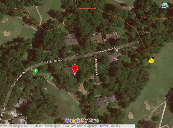
Red marker: 3353 Plantation Drive. Yellow diamond sign: actual spill location.
That entry included a more precise address than Valdosta had previously reported: 3353 Plantation Drive. Unfortunately, that address is still incorrect. As I have pointed out to GA-EPD, the spill was Continue reading
Valdosta sewage sign, golf course, Valdosta Country Club, Stillhouse Branch 2019-08-23
Friday we found the warning sign on the Valdosta Country Club green for the Wednesday force main sewage spill, thanks to Valdosta Utilities Environmental Manager Scott Fowler, who told me where it was. Sara Jay has tested downstream for WWALS, and maybe we can get the Valdosta water quality testing data, as well. Although there is some ambiguity as to which way downstream is.
![[Sewage Spill]](https://www.wwals.net/pictures/2019-08-23--vld-country-club-sewer/20190823_152201.jpg)
“It stinks,” said a man on a golf cart on the green, as I was taking pictures. Continue reading
Valdosta Sewage spill into Stillhouse Branch, Withlacoochee River 2019-08-21
Credit for telling the public, but no credit for a very vague report, in the latest sewage spill in the City of Valdosta.
Every address on Plantation Drive is in the 3300 block, so that locates the spill only within 4,000 feet. Valdosta does know the name of that “local stream,” which is Stillhouse Branch, and where it goes, which is into the Withlacoochee River, upstream from US 41 and Langdale Park.
![[Plantation Drive]](https://www.wwals.net/pictures/2019-08-21--valdosta-plantation-drive-spill/tax-assessor-map.jpg)
By “on a golf course” we can deduce the spill must have been Continue reading
Rain and Levels, Withlacoochee River, US 41 Gauge, Valdosta 2010-2018
The rainiest season in south Georgia and north Florida is the summer, yet that’s when rivers are usually the lowest. Here are seven years of data from the USGS Withlacoochee River Gauge at US 41 (North Valdosta Road) in Valdosta, Georgia. Rain is pretty steady through the year (except when there’s no rain), yet the river level varies wildly, highest in the winter, usually. Unless there are hurricanes in the fall, as happened in 2017 and 2016.
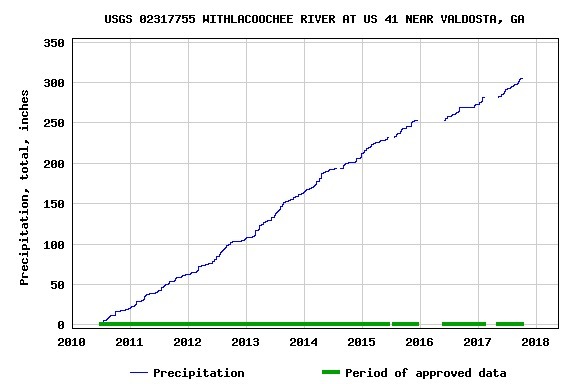
Rain Years 2010-2018
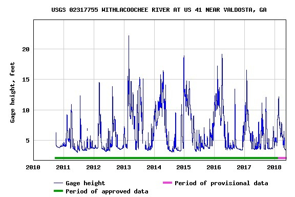
Level Years 2010-2018
Why does this happen? Continue reading
Rivers Seven Days After Irma 2017-09-17
Looks like we may finally see Action stage tomorrow on the Withlacoochee River above Valdosta @ Skipper Bridge Road. This is upstream from Valdosta’s Withlacoochee Wastewater Treatment Plant, so it’s a good thing that didn’t spill during Irma. The Alapaha River at Statenville peaked Tuesday and probably would be a fine ride (what shoals?) today. The New and The Santa Fe Rivers are still flooding, and that’s still raising the Suwannee River all the way to the Gulf, and there’s minor flooding all the way up at Fargo, so another surge of high levels may follow on the Suwannee. The I-75 Santa Fe River bridge never did close.

2017-09-17 Withlacoochee River above Valdosta @ Skipper Bridge Road
The Suwannee River at White Springs peaked Continue reading
River Gage Projections after Hurricane Irma 2017-09-14
Update 2017-09-15: On the seventh day.
Update 2017-09-15: Added Suwannee River at Wilcox @ US 19, plus another image for the Gage Map.
Hurricane Irma flooded the Suwannee River at White Springs, the Santa Fe River especially at Fort White, with a new record for the New River new Lake Butler. It did not flood the Withlacoochee or Alapaha Rivers.

2017-09-14 Suwannee River at White Springs
FDOT says the I-75 bridge over the Santa Fe River Continue reading
Flooding at Valdosta, 2016-04-04
Wondering why Valdosta is having an overflow problem? It was rain on Valdosta, and north of Valdosta.
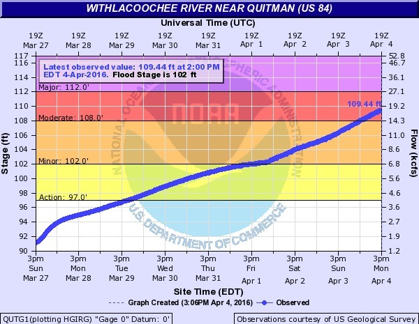
Not so much northwest on the Little River, nor even west on Okapilco Creek: Continue reading
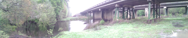
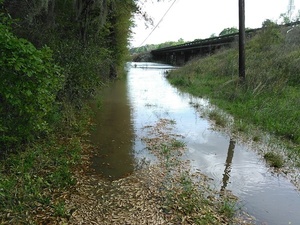
Withlacoochee River US 41 just before flood, 2016-03-31
Sunday there was parking under the bridge, now that’s under water.
 The intended put-in for
this Sunday’s Withlacoochee Outing,
is just downstream from here, so we’re rescheduling that one for
Ray’s Millpond,
875 Rays Mill Pond Rd., Ray City, GA 31645,
still 9AM March 20th 2016.
Directions: From Valdosta, north on Bemiss Road (GA 125) to Ray City, right on Jones St. to boat ramp.
The intended put-in for
this Sunday’s Withlacoochee Outing,
is just downstream from here, so we’re rescheduling that one for
Ray’s Millpond,
875 Rays Mill Pond Rd., Ray City, GA 31645,
still 9AM March 20th 2016.
Directions: From Valdosta, north on Bemiss Road (GA 125) to Ray City, right on Jones St. to boat ramp.
It’s 14.75 feet, just below 15 foot flood at the Continue reading
US 41 access to Withlacoochee River
On the north side of US 41, there’s good access from Val Del Road to the Withlacoochee River.
 From US 41 (North Valdosta Road), turn north on Val Del Road,
and your next right is a turnoff to a gravelled road that bends sharply right into the woods, which leads back to the north side of US 41 and down to the Withlacoochee River.
It was a bit muddy in the rain this morning, but there were no big potholes,
and the river slope is easy access.
The river was high, 9.8 feet, but still well below the 15 foot flood level
on the
US 41 Gage on this bridge.
From US 41 (North Valdosta Road), turn north on Val Del Road,
and your next right is a turnoff to a gravelled road that bends sharply right into the woods, which leads back to the north side of US 41 and down to the Withlacoochee River.
It was a bit muddy in the rain this morning, but there were no big potholes,
and the river slope is easy access.
The river was high, 9.8 feet, but still well below the 15 foot flood level
on the
US 41 Gage on this bridge.