
Commissioners from counties on both sides of the Suwannee River saw the sinkholes and big oaks and pines directly above and near where
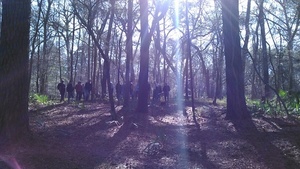 Sabal Trail proposes to bore under Suwannee River State Park and the River,
led by WWALS board member and Hamilton County resident Chris Mericle,
assisted by Debra Johnson of SpectraBusters, Merrillee Malwitz-Jipson of Our Santa Fe River (OSFR), and others from as far away as south Florida.
All but one of the Suwannee County Commissioners were there, and he had a good excuse.
They also saw Falmouth Spring, which is part of a cave system which Sabal Trail claims is 100 feet deep. Both county commissions meet Tuesday March 1st; see below for details.
WWALS videos
Sabal Trail proposes to bore under Suwannee River State Park and the River,
led by WWALS board member and Hamilton County resident Chris Mericle,
assisted by Debra Johnson of SpectraBusters, Merrillee Malwitz-Jipson of Our Santa Fe River (OSFR), and others from as far away as south Florida.
All but one of the Suwannee County Commissioners were there, and he had a good excuse.
They also saw Falmouth Spring, which is part of a cave system which Sabal Trail claims is 100 feet deep. Both county commissions meet Tuesday March 1st; see below for details.
WWALS videos to come now posted.
You can see Continue reading
Category Archives: Quantity
Sinkhole 60″ from Sabal Trail path

On the hike to the Sabal Trail pipeline path on the Suwannee River.
More pictures and video to come. Meanwhile, see previous expeditions to that site,
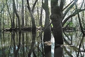
Suwannee River still above walkway at Suwannee River Campsites.

That’s the Suwannee River Campsites Ramp, at 0.414, -83.159167.
According to the nearest gauge, slightly downstream near the Withlacoochee Confluence at Ellaville, the water level was about 13.25 feet on the morning of Saturday 18 February 2018, as we were preparing for the hike to the Sabal Trail pipeline path on the Suwannee River.
Hutchinson Mill Creek at Withlacoochee River, GA 122
Deadfalls on this creek,
backing up flood waters onto Skipper Bridge Road forcing a bridge to close in 2009,
 were one reason for the formation of WWALS.
Here are some pictures and a very brief movie.
were one reason for the formation of WWALS.
Here are some pictures and a very brief movie.
In a typical day for a Waterkeeper®, starting slow after a road trip to Atlanta the previous day with several Riverkeepers and other environmental organizations, I was preparing for the movie in Live Oak Friday evening when I got a message from Noelani Mathews wanting an interview about the pipeline movie. As I threw a kayak in the truck, the Yellow Dog hopped in, and Continue reading
Conversations with Noah Valenstein, E.D., SRWMD in Columbia County 2016-02-04
It’s not for shipping water to Jacksonville, it’s not much changed from last year, no money is allocated for it yet, and people should get involved in the process, said Noah Valenstein, the new Executive Director of the Suwannee River Water Management District (SRWMD), in answer to questions from Jim Tatum and Merillee Malwitz-Jipson of Our Santa Fe River (OSFR) and me about the Falling Creek Aquifer Recharge Project at the Columbia County Commission meeting last Thursday, 4 February 2016. Plus Sabal Trail, Amtrak and that chicken farm.
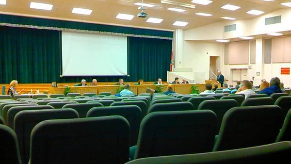
Valenstein answered Jim during the Commission meeting. See also Jim’s report for OSFR. I stayed afterwards and had a longer discussion with Valenstein. Some notes from memory: Continue reading
Skipper Bridge, 17.66 feet, flood level 15 feet
The water level continued up from yesterday, when it was
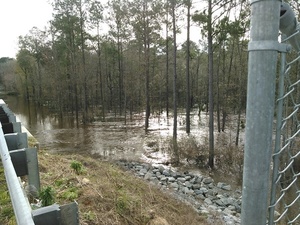 17.66 feet on the USGS guage at Skipper Bridge in Lowndes County, Georgia
at 9:46 AM when I took these pictures.
Flood stage is 15 feet.
It was so high you could have floated over the chain link fence the county
put in when
it replaced the bridge, thus preventing normal use of this bridge
as a Withlacoochee River access point on the
Withlacoochee and Little River Water Trail.
17.66 feet on the USGS guage at Skipper Bridge in Lowndes County, Georgia
at 9:46 AM when I took these pictures.
Flood stage is 15 feet.
It was so high you could have floated over the chain link fence the county
put in when
it replaced the bridge, thus preventing normal use of this bridge
as a Withlacoochee River access point on the
Withlacoochee and Little River Water Trail.
-jsq
You can join this fun and work by becoming a WWALS member today!
Downstream panorama 30.9016667, 83.2930556
Continue readingWithlacoochee River at GA 122

This is a panorama; click on it to see the full picture.
See also Withlacoochee and Little River Water Trail and the pictures I took at Skipper Bridge a few minutes later. There’s a guage at Skipper Bridge, which read 17.66 feet, well above flood level.
-jsq
You can join this fun and work by becoming a WWALS member today!
Noah Valenstein, SRWMD E.D. @ Columbia County, FL Commission
He answered a few questions about Falling Creek Aquifer Recharge.

See Questions to SRWMD Director for context. More detail to come.
-jsq
You can join this fun and work by becoming a WWALS member today!
Questions to SRWMD Director at Columbia County Commission –Columbia County News 2016-02-04
The Columbia County News has made it easier to ask questions, especially about a very expensive river and aquifer project.
 When: 5:30 PM Thursday 4 February 2016
Where:
Columbia BOCC
372 West Duval Street
Lake City, Florida
What: Why is the SRMD board going to vote next week on sucking up Suwannee River water through a 48″ pipe to Falling Creek Park in an Aquifer Recharge scheme?
Stew Lilker, Columbia County News, 3 February 2016, Suwannee River Water Management Chief at the County 5 Thursday Night: Questions Accepted,
It has been said that fresh clean water is Continue reading
On Columbia County agenda 2016-02-04? Falling Creek Aquifer Recharge
Why is the SRWMD Executive Director on the Columbia County agenda a few days before the SRWMD board meeting with the Falling Creek Aquifer Recharge project?
![]() Under
“Presentation of Ministerial Matters Not Requiring Public Comment”,
on the
February 4th agenda for the Columbia Board of County Commissioners:
Under
“Presentation of Ministerial Matters Not Requiring Public Comment”,
on the
February 4th agenda for the Columbia Board of County Commissioners:
Noah Valenstein, Executive Director, Suwannee River Water Management District
(1) Introduction
Introduction of what? Of the Continue reading