Update 2017-01-19:
Videos: NFRWSP Plan passed at joint SRWMD-SJRWMD Board Meeting 2017-01-17.
Update 2017-01-12: SRWMD did post responses to comments on the NFRWSP: they posted them a week in advance of planned adoption. Come on down to Alachua Tuesday!
Next week in Alachua without further public meetings or response to those who wrote in,
SRWMD and SJRWMD plan to approve the North Florida Regional Water Supply Plan (NFRWSP), as the only item on the agenda.
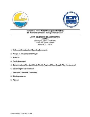
When: 11AM Tuesday 17 January 2017
Where: 15100 NW 142nd Terrace, Alachua, FL 32615
Event: facebook
WWALS never got a response to
our letter about the NFRWSP,
not about less water withdrawal, nor about better modeling and data,
nor about more water retention,
nor specifically about ditching the Rube Goldberg Falling Creek Aquifer Recharge Project for Dennis Price P.G.’s more cost-effective solution,
nor with any mention of participation from farther afield in Florida nor in Georgia, for that matter.
The language of the
memorandum accompanying the agenda is rather Orwellian:
The NFRWSP has identified sufficient sources of water to
meet the needs of the environment and the projected demands through
2035.
That sounds like the environment is making projected demands.
Actually, the maps in the NFRWSP are pretty clear that Jacksonville is making
the most demands for water, along with other cities and corporate agriculture, and the plan would take from the environment, mostly from the Suwannee River Basin, to get that water.
Our Santa Fe River
sums it up pretty well: Continue reading →

 The playwright could have added a bit more suspense.
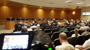
After listening to almost two dozen public comments, many recommending tabling the North Florida Regional Water Supply Plan (NFRWSP) or a moratorium on new water withdrawal permits,
the boards of the Suwannee River Water Management District and the
St Johns River Water Management District each voted unanimously to approve.
The playwright could have added a bit more suspense.
After listening to almost two dozen public comments, many recommending tabling the North Florida Regional Water Supply Plan (NFRWSP) or a moratorium on new water withdrawal permits,
the boards of the Suwannee River Water Management District and the
St Johns River Water Management District each voted unanimously to approve.