Protests across Florida against Sabal Trail, which is worse than reporters think

It’s not just two connected pipelines; it’s at least five just in Florida. Audubon Florida did endorse Sabal Trail starting with FPL’s first announcement. And sure, Ms. Grover, your “safety programs are designed to prevent pipeline failures”, but they haven’t actually stopped numerous incidents of corrosion, leaks, explosions, and compressor station blowouts. Other than those things, it’s a pretty good story.

Beth Kassab and Kevin Spear, Orlando Sentinel, 2017-04-01, Gas pipeline across Central Florida brings cheap energy and protests,

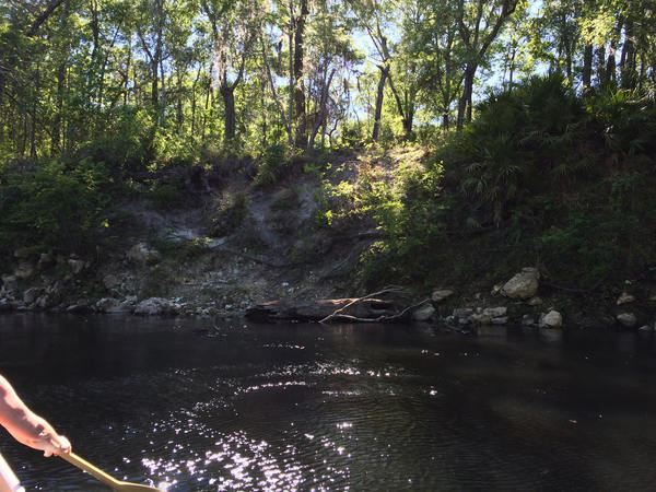
The WWALS Watershed Coalition, which advocates for protection of Florida and Georgia rivers, has staunchly opposed nearly every aspect of Sabal Trail, which crosses under the Suwannee, Santa Fe and many other rivers.


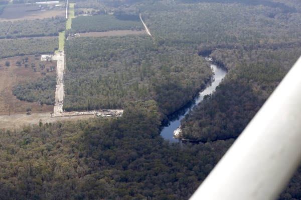
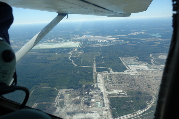
South to Suwannee River, HDD Suwannee County, RoW with pipe already buried, 30.4117310, -83.1566490

Coalition spokesman John Quarterman called the pipeline a profit bonanza for private companies and a boondoggle for utility customers.

Well, I said it’s a boondoggle for the utility, namely FPL, at the expense of its customers. Here’s why I say that, including Continue reading

West Mims Fire in Upper Suwannee River watershed in Okefenokee Swamp 2017-04-15

Now is not a good time to stay overnight in the Okefenokee Swamp, or to travel at night between Fargo and Moniac, because of smoke.

Lightning started the West Mims fire Thursday, apparently west of Moniac, Georgia in Baker County, Florida. That was in the St Marys River watershed, but the fire has since expanded west and north into the upper Suwannee River watershed and Ware County, Georgia. According to today’s update from InciWeb, the Incident Information System, the fire now involves 13,000 acres and is only 3% contained. Even with 110 firefighters and a variety of equipment, the estimated containment date is two months from now: “Thursday June 15th, 2017 approx. 12:00 AM”. It is a southern fire forest, after all.

Incident Map
Map from InciWeb 2017-04-15. Approximate Location 30.574 latitude, -82.323 longitude.

It’s probably best not to go there at night, since InciWeb says: Continue reading

Lower and Middle Suwannee River Basin Management Action Plan (BMAP) Meeting 2017-04-13

Today in Live Oak: what FDEP is doing about water quality and quantity in the Suwannee Basin below the Withlacoochee Confluence. Agenda

See the PDF or the transcription below.

Lower and Middle Suwannee River Basin Management Action Plan (BMAP) Meeting

DATE: Thursday, April 13, 2017
TIME: 6:00 PM
PLACE: Suwannee River Water Management District
Board Room
9225 CR 49
Live Oak, FL 32060

THIS MEETING IS OPEN TO THE PUBLIC

AGENDA Continue reading

Agenda, Santa Fe River Springs Protection Forum 2017-04-13

The agenda says it’s for a Santa Fe River Springs Protection Forum, but the venue at Otter Springs is on the Suwannee River downstream of the Santa Fe River, and Potash Corp Field Trip Summary is about the phosphate mine in Hamilton County well upstream on the Suwannee River, using pictures from the WWALS Southwings flight of 22 October 2016. Many people and organizations are concerned about an attempt to start another phosphate mine in Union and Bradford Counties, which are upstream of the Santa Fe River.

Follow the link for the agenda PDF, and there’s an image below.

When: 9:30 am – 3:00 pm, Thursday, April 13, 2017

Where: Otter Springs Campground
6470 SW 80th Avenue, Trenton FL, 32693

What: Santa Fe River Springs Protection Forum

Bee Haven Bay, now PCS Phosphate mine, 30.5089370, -82.8682070

Bee Haven Bay, now PCS Phosphate mine,
Picture by WWALS member Jim Tatum of Our Santa Fe River on WWALS Southwings flight 2017-10-22 piloted by Roy Zimmer, with Continue reading

River spraying erosion, Withlacoochee River

Received yesterday:

The property owner sprayed this section of bank along the Withlacoochee with roundup several years ago. This picture clearly shows why we need to protect and leave intact the vegetation along the river banks. The erosion has only occurred at the section that was denuded of vegetation.

Chris Mericle

Denuded bluff,
Madison County side, 30.4162370, -83.2077630.

 -jsq, John S. Quarterman, Suwannee RIVERKEEPER®

You can join this fun and work by becoming a WWALS member today!

Agenda, WWALS Quarterly Board Meeting 2017-04-12

Come on up to Adel Wednesday evening and see sausage being made! If you want to attend by telephone, contact us.

Draft Agenda
WWALS Quarterly Board Meeting
7:30 PM Thursday 12 April 2017
IHOP, 1200 W 4th St, Adel, GA 31620

WWALS logo

All WWALS Board Members are expected to attend in person or by telephone.
The more done on the board list, the less time we’ll have to spend on them in this meeting.

All WWALS members, especially committee members, are invited to attend, as is the general public.

Board Members:

Continue reading