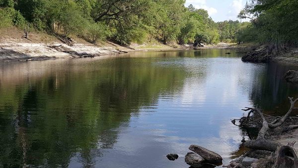
With reference Yellow Dog.

Taken from Tyler Bridge on river mile 78.71 at Franklinville Road.
-jsq, John S. Quarterman, Suwannee RIVERKEEPER®
You can join this fun and work by becoming a WWALS member today!

With reference Yellow Dog.
Taken from Tyler Bridge on river mile 78.71 at Franklinville Road.
-jsq, John S. Quarterman, Suwannee RIVERKEEPER®
You can join this fun and work by becoming a WWALS member today!
Please call your U.S. Senators today and ask them to oppose Senate Bill 951, the so-called Regulatory Accountability Act, which would actually obstruct enforcing regulations that protect our clean air and water. As Suwannee Riverkeeper among 121 U.S. Waterkeeper Members and Affiliates told the EPA yesterday, we need stronger protections against coal ash, unnecessary pipelines, and fracking, not less. Solar and wind power already employ more people than coal, oil, and gas combined, so there’s no economic reason to let the failing fossil fuel industry crimp our regulatory system like this, and every reason of drinking water, industry, recreation, and wildlife to keep it clean.
That’s 202-224-3121
Georgia: David Perdue and Johnny Isakson
Florida: Bill Nelson and Marco Rubio
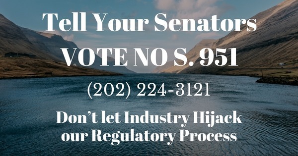
Larissa Liebmann, Waterkeeper Alliance, 15 May 2017, Don’t let Industry Hijack our Regulatory Process! Continue reading
Update 2017-05-17: OK, the water’s gotten too low at the original location, so we’re moving downstream to Woods Ferry Tract Launch to Suwannee Springs.
Hands Across the Sand on the Suwannee Saturday! The river is quite low (48.78 feet NAVD on the White Springs gage), but it looks doable from the put-in and take-out. A ranger at Stephen Foster State Park told me paddling from White Springs to Swift Creek would be doable, perhaps with a few dry spots. I’ll also call a local outfitter or two for their opinions.
Meanwhile, bring bug spray (gnats) and a rope (to pull your boat over sand bars), and we’re still on for 9AM Saturday 20 May 2017. See the outing announcement for more details.
Plus: that’s the day of Hands Across the Sand, “Say NO to dirty fuels and YES to clean energy”. WWALS has been saying that for years, so somewhere on the Suwannee we will stop and do Hands Across the Sand against the Sabal Trail fracked methane pipeline and for solar power.
The VDT and the City of Valdosta are feuding again about water quality,
this time about drinking water (not sewage).
 They’re both wrong and both right, and neither named
any of the other poor local water sources.
The VDT didn’t make this story easy to follow by omitting the key piece
from its first online story and not quoting its source,
and the city didn’t acknowledge some main points the VDT made.
They’re both wrong and both right, and neither named
any of the other poor local water sources.
The VDT didn’t make this story easy to follow by omitting the key piece
from its first online story and not quoting its source,
and the city didn’t acknowledge some main points the VDT made.
Kimberly Cannon, Valdosta Daily Times, 10 May 2017, City celebrates water: Mayor refutes water quality report, Continue reading
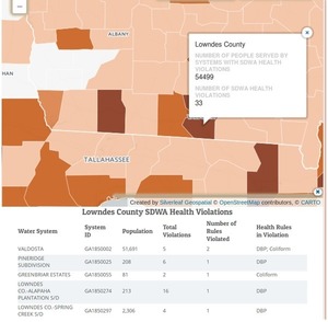
Valdosta indeed didn’t have the worst water treatment violations in Lowndes County, Georgia, but it was worse than any nearby city in Georgia or Florida (and Lowndes County was worse than any nearby county). Once again, the Valdosta Daily Times said (twice) that Valdosta “is now in full compliance”. This is about drinking water treatment; sewage is another story. But in both cases, if Valdosta doesn’t want the local newspaper to treat the city as the villain of the piece, maybe it should stop reacting like one.

The above screenshot from Threats on Tap: Widespread Violations Highlight Need for Investment in Water Infrastructure and Protections shows Georgia has been pretty bad, but Florida was much worse.
Let’s look at the area around Valdosta. Continue reading
Obviously nobody lives in most of the Okefenokee Swamp or the Osceola National Forest, but also most of Clinch County is unpopulated west of the Swamp, as is much of the Gulf coast along the Suwannee River Estuary, from Cedar Key north to Horsehoe Bay, plus large parts of Dixie and Lafayette Counties west of the Suwannee River.
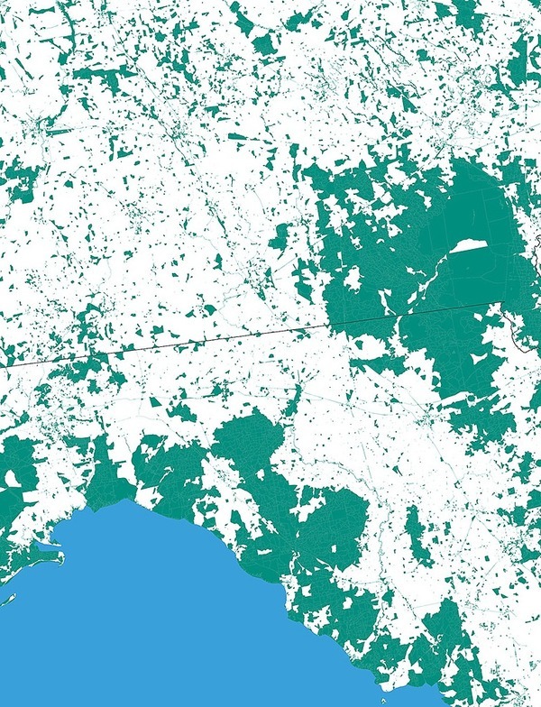
Nobody Lives Here:
Unpopulated U.S. Census Blocks,
screenshot by jsq from interactive map by
mapsbynik.
Update 2017-06-20: As someone pointed out, rangers do live in the Okefenokee Swamp, presumably in the white area along the access road.
Cedar Key is the island at the bottom of the map, and from a bit north on the Gulf Coast you can follow Continue reading
Let the sun rise by the sea, down where Sabal Trail would ship LNG.
When: 6PM Tuesday, May 23, 2017
Where:
Hollywood Beach Culture Center
1301 S. Ocean Drive, Hollywood, FL 33019
Event: facebook
Flyer: Follow this link to PDF, and JPG image below.

WWALS was this year’s Watershed Group of the Year at Georgia River Network’s annual River Celebration Awards, presented at Little Ocmulgee State Park, 28 April 2017.

Photo: Joe Cook for GRN
On hand to receive the award were Gretchen Quarterman, WWALS Executive Director, John S. Quarterman, WWALS President and Suwannee Riverkeeper, and Dave Hetzel, WWALS Ambassador. Presenting the award were Dana Skelton, GRN Executive Director and Gwyneth Moody, Director of Programs & Outreach. Continue reading
Apparently Charlie Dean has one more day left on an FDEP permit to build a dock at Nichols Spring on the Withlacoochee (south) River at Lat: 28° 50′ 23.6438″ Lon: -82° 12′ 9.8242″ (28.839901, -82.202729), at SR 44 on CR 251 West, Wildwood, in Sumter County, Florida. The nearest house, maybe his, is at 5927 CR 251W, Lake Panasoffkee, FL 33538.
Possibly this is former Florida State Senator Charlie Dean (R-District 5), who represented parts or all of Baker, Citrus, Columbia, Dixie, Gilchrist, Lafayette, Levy, Marion, Suwannee, and Union Counties, Florida, but curiously not Sumter County.
Found via Continue reading
A primary objective of the WWALS Science Committee is to compile published scientific literature for the Suwannee basin. We are doing this using online search engines including the University of Georgia System Galileo program and Google Scholar. Remarkably, our searches have identified thousands of published scientific papers and reports that link to the keyword, “Suwannee”. Examination of many revealed that they describe research using dissolved organic matter isolated from the Suwannee River near Fargo, GA. This is the material that gives the water its special color.
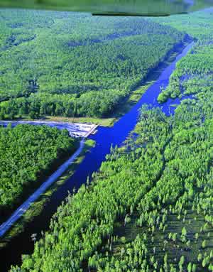
Photo: Richard T. Bryant, in Pamela P. Holliday, Sherpa Guides, unknown date,
The State of the Swamp: The Suwannee River Sill and DuPont’s Mining Proposal Grab attention and Concern in the Okefenokee
Digging further Continue reading