Yet more Valdosta wastewater spills

Maybe soon this February baker’s dozen of wastewater spills will be a thing of the past, but for now it’s deja vu similar to but worse than last February.
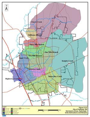
300x388 Figure 2.2.5. Sub-basins Areas, in Section 2 Methodology, by City of Valdosta, for WWALS.net, 14 January 2011 It looks like Valdosta has updated, as repeatedly asked, its schedule for wastewater project completion, with the force main project now aimed at July 2016 and relocation of the Withlacoochee WasteWater Treatment Plant (WWTP) for August 2017. See also Valdosta PR 22 January 2016, Withlacoochee Aerial Sewer Mains Replacement Project.

Those schedule changes are mentioned in the most recent Valdosta News. It does not, however, say which watersheds the various spills affect. I have added * for Alapaha River watershed and ** for Withlacoochee River watershed. It’s not that hard, and Valdosta has a water management plan that spells this all out, with maps. One Mile Branch** and Two Mile Branch** flow into Sugar Creek**, which goes into the Withlacoochee River**. Knights Creek* goes into Mud Creek* which goes into the Alapahoochee* River and then the Alapaha River*, eventually joining the Suwannee River in Florida, as does the Withlacoochee. Valdosta Utilities and Public Relations know all that. But why should every citizen, Continue reading

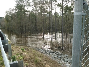
Skipper Bridge, 17.66 feet, flood level 15 feet

The water level continued up from yesterday, when it was Downstream 31.0116939, -83.2915878 17.66 feet on the USGS guage at Skipper Bridge in Lowndes County, Georgia at 9:46 AM when I took these pictures. Flood stage is 15 feet. It was so high you could have floated over the chain link fence the county put in when it replaced the bridge, thus preventing normal use of this bridge as a Withlacoochee River access point on the Withlacoochee and Little River Water Trail.

-jsq

You can join this fun and work by becoming a WWALS member today!

Downstream panorama 30.9016667, 83.2930556

Continue reading

Withlacoochee River at GA 122

This is a panorama; click on it to see the full picture.

See also Withlacoochee and Little River Water Trail and the pictures I took at Skipper Bridge a few minutes later. There’s a guage at Skipper Bridge, which read 17.66 feet, well above flood level.

-jsq

You can join this fun and work by becoming a WWALS member today!

Noah Valenstein, SRWMD E.D. @ Columbia County, FL Commission

He answered a few questions about Falling Creek Aquifer Recharge.

See Questions to SRWMD Director for context. More detail to come.

-jsq

You can join this fun and work by becoming a WWALS member today!

Natural gas isn’t the answer –north Florida residents to WTXL about Sabal Trail

Fireworks at last Monday’s Suwannee BOCC, although after they had already voted to Chris Mericle at podium hike to the Suwannee River soon<. WWALS board member Chris Mericle, who will be their guide, also spoke in the meeting. The recent issuance of certificates by FERC called out the Suwannee River and Suwannee and Hamilton Counties by name, so action by those counties is now even more important.

Paulo Salazar, WTXL, 3 February 2016, Sabal Trail Pipeline Causing Concern for Suwannee County Residents, Continue reading