Tag Archives: Alapaha Rise

Alapaha Swallets Dye Trace Project 2016-10-01

Down at the designation of the new Jennings Bluff State Geological Site with Dead River Sink 2023-03-17 the Florida Geological Survey (FGS) was giving out links to a report on the Alapaha Swallets Dye Trace Project.

That’s where FGS, FDEP, and SRWMD put fluorescent green dye in the Dead River Sink, back on June 22, 2016, and watched for it to come back up.

[Before and After]
Before and After

As you can see by the graph, the dye came back up four days later in the ALapaha River Rise, and eight days later in Holton Creek Rise.

The report is available Continue reading

Sulak’s Defeat at Jennings Defeat 2020-08-26

Explorer Dr. Ken Sulak has solved an Alapaha River rapids naming mystery. He recounts:


So in 1797, Samuel Taylor Coleridge wrote a poem inspired by a dream.

Where Alph, the sacred river, ran
Through caverns measureless to man
   Down to a sunless sea.

So twice five miles of fertile ground
With walls and towers were girdled round:
And there were gardens bright with sinuous rills,
Where blossomed many an incense-bearing tree;
And here were forests ancient as the hills,
Enfolding sunny spots of greenery.

Insert three ‘A” and the dreamscape river becomes the Alapaha, and appropriately so. Yesterday, I embarked on the foolish idea of a solo kayak journey up 3 miles of the Alapaha from Sasser Landing (just below the confluence of the Alapaha and the Alapahoochee rivers) to the site of the 1800s Roebucks Ferry and later Roebucks Bridge.

[Jennings Defeat Rapids, Ogeechee Gum, GS&F RR trestle below CR 150]
Jennings Defeat Rapids, Ogeechee Gum, GS&F RR trestle below CR 150

That crossing brought settlers and other travelers from Jacksonville and Fernandina along the GA/FL border across the Alapaha to Miccotown, the old Seminole Indian town in the triangle of land protected by the two flanking rivers. The road/trail (gone now on both sides) continued west across the Alapahoochee at the site of the early 1900s Beatty Bridge (undoubtedly preceded in the mid-1800s by an undocumented ferry), and on to Hickstown in Madison County and westward. Miccotown became the first county seat of Hamilton County as the settlers suppressed the Seminoles and the old Indian town faded into obscurity in 1839. Continue reading

Deese-Howard Ramp to Gibson County Park, Suwannee River, 2019-06-01

Update 2019-05-22: Moved by the Outings Committee to Allen Ramp on the Withlacoochee River to Suwannee River State Park.

This is a 12 mile paddle on the Suwannee River. We will meet at Deese-Howard Public Boat Ramp at 8:30 to unload kayaks and gear before the 12 mile shuttle to Gibson County Park begins at 9 a.m. You will probably need to use the Lat/Long coordinates with your GPS to find the ramp easier.

We will pass Holton Creek River Camp, where we will stop for a break and a swim.

Just before the takeout this section of the river also includes the Alapaha Rise, an interesting natural feature that is worth the short side trip.

When: Gather 8:30 AM, Launch 10AM, Saturday, June 1, 2019

Put In: Deese Howard Boat Ramp, 107th Road, Live Oak, FL 32060, Suwannee County.

GPS: 30.41439, -82.96292

Take Out: Gibson Park Ramp, 6844 SW CR 751, Jasper, FL 32052. From Jasper, Hamilton County, FL, travel southwest on SW CR 249 to SW CR 751; turn left and boat ramp is on the right in Gibson County Park, in Hamilton County.

Bring: the usual personal flotation device, boat paddles, food, drinking water, warm clothes, and first aid kit. Also trash pickers and trash bags: every WWALS outing is also a cleanup.

Free: This outing is free to WWALS members, and $10 (ten dollars) for non-members. We recommend you support the work of WWALS by becoming a WWALS member today!

Event: facebook, meetup

Alapaha Rise,
Photo: Beth Gammie, of Alapaha River Rise, on Southwings flight for WWALS with pilot E.M. Beck, 2016-11-23.

Continue reading

State geologist Greenhalgh says BMPs don’t work to solve BMAPs

Someone inside FDEP has been brave enough for years to say the emperor has no clothes regarding contamination in the Suwannee River Basin.

Suiting up, Thomas Greenhalgh
Photo: John S. Quarterman for WWALS, of Thomas Greenhalgh suiting up at the Alapaha Dye Test, 2016-06-22.

Dinah Voyles Pulver, The Daytona-Beach News-Journal, 24 November 2018, State geologist challenging springs action plan raised questions before, Continue reading

BMAP petition letters including from a Florida state springs expert

Unlike FDEP’s BMAP plans, “When a new building code is final in Florida, [Rusty] Payton [CEO, Florida Home Builders Association] said, “there’s always six months between the final rule and the date the rule takes effect.” Because of his organization’s petition for more time to file a protest, none of Florida’s new Basin Management Action Plans (BMAPs) have gone into effect yet, which gives spring and river advocates (and FDEP) more time to try to fix them.

Dinah Voyles Pulver, Daily Commercial, 30 July 2018, Groups protest new Florida springs action plans,

A sweeping effort to adopt action plans to improve water quality in 13 springs systems across the state is on hold after a dozen groups and individuals asked to intervene with the Florida Department of Environmental Protection, including one of the department’s own springs experts.

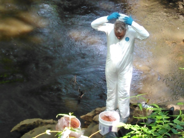
Thomas Greenhalgh, a hydrogeologist with the department’s Florida Geological Survey, is one of two people who asked for an administrative hearing on one of the 13 “basin management action plans” signed by Noah Valenstein in late June.
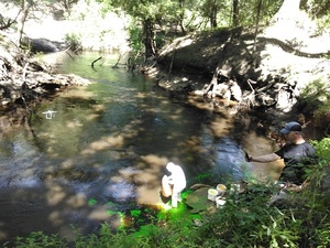
Suiting up, Thomas Greenhalgh
Thomas Greenhalgh suiting up before releasing dye into the Dead River of the Alapaha River to go into the Dead River Sink, 2016-06-22, Picture by John S. Quarterman for WWALS.

“There are many claims and statements in the BMAP that I believe are inaccurate and unsubstantiated,” wrote Greenhalgh 
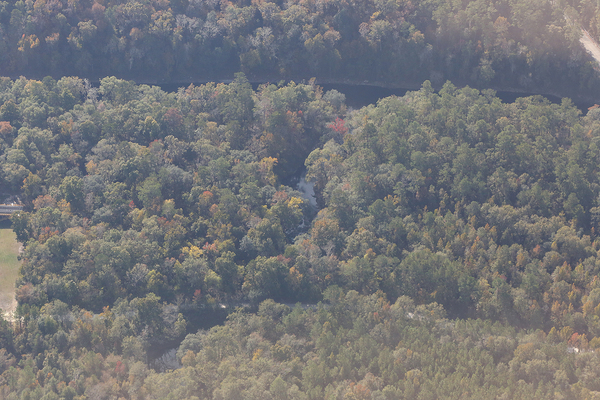
in seeking a state hearing on the plan for the Suwannee River, where he owns property.

He’s not alone.

In addition Continue reading

Gibson Park to CR 141, Suwannee River, 2017-08-13

A pleasant just over five mile Sunday paddle on the Suwannee River as we take a short upstream paddle to the Alapaha River Rise. Then enjoy the river’s current downstream past the Alapaha River Confluence (there may be water in the Alapaha) to County Road 141 Ramp. There are a couple of springs along the way. Those still feeling energetic can paddle a few more thousand feet down to the Sabal Trail crossing and back to CR 141.


Suwannee River beach, 2015-08-15, 30.4193954, -83.1344223

Bring the usual personal flotation device, water, snacks, first aid kit, and gloves, trash bag, and gripper because every WWALS outing is also a cleanup. If you do not have a boat, ask us, or contact one of the many outfitters.

When: 9AM, Sunday, August 13, 2017

Put-In: Gibson Park Ramp, SRWT MILE 135.4, 6844 SW CR 751, Jasper, FL 32052, From Jasper, travel southwest on SW CR 249 to SW CR 751; turn left and boat ramp is on the right in Gibson Park.

GPS: Continue reading

Delineation of Spring Protection Areas

These figures tell the story of springsheds in a coastal lowland karst plain such as much of the Suwannee River Basin. Maybe you already know all this, but if you don’t, these pictures may help make sense of Springsheds and Water Withdrawal Permits in the Suwannee River Basin.

Fig. 11_1: Groundwater Basin

A spring is fed from a ground-water basin.

Fig. 11_1: Groundwater Basin

Fig. 12_1: Springshed Protection Area

Continue reading

Aerials: Dry Alapaha River and the Alapaha Rise 2016-11-23

The Alapaha River is dry much of the year in most of its Florida run, because it goes underground upstream and comes back up in the Alapaha Rise, which is actually upstream on the Suwannee River from the Alapaha Confluence. The Cody Scarp causes this underground river phenomenon. See also the WWALS Alapaha River Water Trail.

CR 751 bridge, dry Alapaha River, 30.4485760, -83.0968860

CR 751 bridge, dry Alapaha River,

Alapaha River Confluence with Suwannee River, 30.4368660, -83.0982100

Continue reading

Where to look for dye from Alapaha Dye test

Update 2023-05-01: Alapaha Swallets Dye Trace Project 2016-10-01.

Tom Greenhalgh dying the Dead River, Harley Means, and a drone Tom Greenhalgh started putting the dye in the Dead River Swallet about 11:06 this morning, with Harley Means observing in this picture, plus a drone also taking pictures. See below for where to look for the dye coming back up in the next few days. If you see it, please take a water sample for SRWMD. Continue reading

Dye test in Dead River Sink on Alapaha River

Update 2016-06-22: Dye test into the Dead River Sink: it came back up several days later and eighteen river miles south, in the Alapaha River Rise and Holton Bluff Spring, both on the Suwannee River.

The Alapaha River disappears underground in dry seasons, and nobody has ever known where it comes back up. Soon, we will know.

Green Publishing, 16 June 2016, Dye test held for river basins,

The Florida Geological Survey will be conducing a dye test for the Suwannee River Water Management District in the Upper Suwannee/Alapaha River basins later this month. They will introduce dye into the Dead River Swallet (swallets are sinkholes that capture flow) and a swallet that is located on privately owned land. They will also have sampling devices setup at Continue reading