 It’s the annual WWALS Adopt-A-Stream cleanup, this time at GA 135
on the
Atkinson County side of the Alapaha River, plus if there’s time, the
Berrien County side.
It’s the annual WWALS Adopt-A-Stream cleanup, this time at GA 135
on the
Atkinson County side of the Alapaha River, plus if there’s time, the
Berrien County side.
When: 9AM Saturday September 26th 2015
Where: Continue reading

It’s the annual WWALS Adopt-A-Stream cleanup, this time at GA 135
on the
Atkinson County side of the Alapaha River, plus if there’s time, the
Berrien County side.
When: 9AM Saturday September 26th 2015
Where: Continue reading
 WWALS Ambassador
Dave Hetzel will speak about the
Alapaha River Water Trail
(now looking to place signs)
and the
Withlacoochee and Little River Water Trail
(Committee just formed and looking for more members)
at the
Southern Georgia Regional Commission Council
meeting 11AM July 23rd in Pearson, GA 31642.
WWALS Ambassador
Dave Hetzel will speak about the
Alapaha River Water Trail
(now looking to place signs)
and the
Withlacoochee and Little River Water Trail
(Committee just formed and looking for more members)
at the
Southern Georgia Regional Commission Council
meeting 11AM July 23rd in Pearson, GA 31642.
Update 2015-07-23: Civic Center, 786 Austin Ave. East, Pearson, GA
According to New Georgia Encyclopedia, Continue reading
Boating on our rivers and water trails for them,
issues and education: 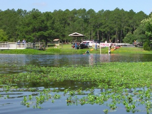 you can help with the fun and work of WWALS!
Here’s much of what can be done laid out in a list of a dozen WWALS Goals for 2015.
The board has at least one opening right now,
and the committees always could use more members. You can apply through the online form.
you can help with the fun and work of WWALS!
Here’s much of what can be done laid out in a list of a dozen WWALS Goals for 2015.
The board has at least one opening right now,
and the committees always could use more members. You can apply through the online form.
See also the monthly newsletter, the news about WWALS, and of course the website with blog, facebook the page and group, and WWALS on twitter, Youtube, and the membership google group. You can become a member or corporate sponsor of WWALS online right now.
The WWALS Executive Committee 11 March 2015 recommended Continue reading
 Expedition leader Bret Wagenhorst’s always-excellent pictures of the
18 April 2015 WWALS Outing
on the
Alapaha River Water Trail.
Expedition leader Bret Wagenhorst’s always-excellent pictures of the
18 April 2015 WWALS Outing
on the
Alapaha River Water Trail.
And don’t forget coming up May 16th theThird annual BIG Little River Paddle Race at Reed Bingham State Park on the Little River. Continue reading
 Update from expedition leader Bret Wagenhorst:
The current weather forecast for Saturday in Alapaha, GA is cloudy with 20% chance of thunderstorms. The water level on the Alapaha River at the Alapaha gauge
is 9.4 ft and appears to be plateauing. [The river has already been going down for a couple of days upstream at the Irwinville gauge. -jsq] Unless there are heavy rains in or north of Alapaha Friday, we should be able to proceed with our planned outing.
It should be a fast trip with the water this high, and with fast, high water comes increased risk, so this is probably not a great outing for a beginner.
Know that the put in is actually Continue reading
Update 2015-04-17: Water’s high, but looks like the outing is on.
 Paddle downstream on the Alapaha River past the Willacoochee River
and the city of Willacoochee,
among ancient cypress, pines, turtles, fish, and birds.
This is a long one, so come prepared:
water, snacks, and as always personal flotation devices.
It’s also remote and possibly difficult with deadfalls,
so please be able to swim or at least float.
If you need a boat, please contact wwalswatershed@gmail.com.
Facebook event.
Paddle downstream on the Alapaha River past the Willacoochee River
and the city of Willacoochee,
among ancient cypress, pines, turtles, fish, and birds.
This is a long one, so come prepared:
water, snacks, and as always personal flotation devices.
It’s also remote and possibly difficult with deadfalls,
so please be able to swim or at least float.
If you need a boat, please contact wwalswatershed@gmail.com.
Facebook event.
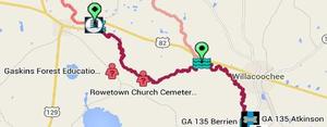
| When: | 8AM April 18th 2015 |
|---|---|
| Shuttle: | 40 min. shuttle |
| Start: | 9AM on the water |
| Duration: | approximately 4 hour paddle |
| Stop: | About 1PM |
| Where: | Rowetown Church Cemetery,
7 miles east of Alapaha, GA via Moore Sawmill Road, on Rowetown Church Road, Berrien County, GA 31.33906, -83.149789 |
This event is FREE! All we ask is that Continue reading
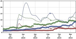 Rainfall can be quite different in Statenville on the Alapaha River as shown here than in Valdosta on the Withlacoochee River.
But remember half of Valdosta drains into the Alapaha River watershed.
Rainfall can be quite different in Statenville on the Alapaha River as shown here than in Valdosta on the Withlacoochee River.
But remember half of Valdosta drains into the Alapaha River watershed.
Here are rainfall and water level graphs from the three USGS Alapaha River gauges in Georgia. The Florida gauge is shown separately, because it use a different base level, and precipitation doesn’t seem to be available from Florida gauges. See also always-current graphs of all the levels. Continue reading
A surprising number of the Board’s nine goals for 2014 have been accomplished, and some new ones have already been added. What goals should WWALS have for 2015?
 Goals accomplished include
becoming an
IRS 501(c)(3)
and raising money for and purchasing
insurance.
Some we’ve been doing right along:
cleanups, including Rivers Alive.
Some are so much the core of what WWALS does that we
didn’t even list them as goals, but we’ve been doing them anyway:
monthly outings
and
indoor events.
Goals accomplished include
becoming an
IRS 501(c)(3)
and raising money for and purchasing
insurance.
Some we’ve been doing right along:
cleanups, including Rivers Alive.
Some are so much the core of what WWALS does that we
didn’t even list them as goals, but we’ve been doing them anyway:
monthly outings
and
indoor events.
The later-added goal of the Alapaha River Water Trail is Continue reading
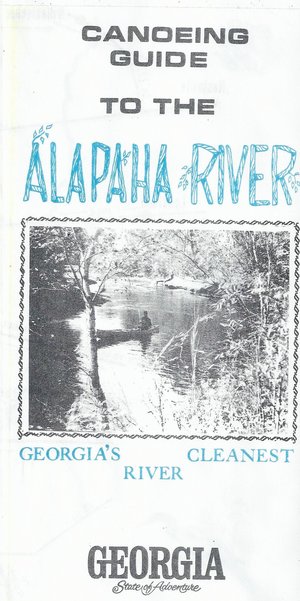 Here’s a different guide to the Alapaha River from the
one WWALS previously received; this one is
courtesy of John Leonard, Executive Director of the
Southern Georgia Regional Commission (SGRC).
The
Alapaha River Water Trail WWALS is currently developing
is merely a continuation of this more than three decade old
Alapaha Canoe Trail.
Here’s a different guide to the Alapaha River from the
one WWALS previously received; this one is
courtesy of John Leonard, Executive Director of the
Southern Georgia Regional Commission (SGRC).
The
Alapaha River Water Trail WWALS is currently developing
is merely a continuation of this more than three decade old
Alapaha Canoe Trail.
John Leonard said that when he started at the predecessor of the SGRC in 1980, calls came in frequently asking about water levels on the Alapaha River. It took him a while to realize why: the Alapaha River Trail had been written up in Southern Living! He did not have Continue reading