Tag Archives: fire

Videos: More people, equipment, and smoke: West Mims Fire Okefenokee update 2017-04-16

Naturally a party of people we know were paddling across the Okefenokee Swamp over the weekend, but far north of the fire, so they had no problems, getting out just before the overnight stops in the Okefenokee NWR close today. Apparently they could see skyglow of the West Mims Fire on the southern horizon at night. Meanwhile, smoke has been seen as far north as North Carolina and I can smell it in Lowndes County, 60 miles west of the fire.
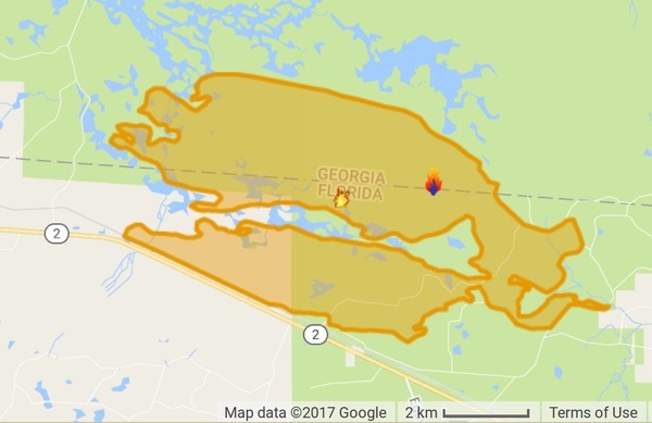
InciWeb map
Map by InciWeb, 16 April 2017.

Hannah Patrick, WWAYTV3, Wilmington, NC, 16 April 2017, Strong winds drive smoke from Georgia Wildfire into NC,

Multiple media outlets report that the National Weather Service in Raleigh said southwest winds pushed the smoke up Sunday from the southeast Georgia fire.

The Division of Environmental Quality air quality index number for the Triangle area of Raleigh, Durham and Chapel Hill hit the orange alert level Sunday. That means people who are sensitive to air quality should stay inside.

Officials believe the smoke is coming from the Georgia fire and not one in McDowell County, North Carolina, that the U.S. Forest Service said was about 85 percent contained as of Sunday.

InciWeb says the number of personnel has increased to 184, the number of engines to 17, and the number of tractor plows to 27; still 5 dozers and one hot shot crew. However, the acreage burned has increased to 18,551, with still only 3% contained, and the same estimated containment date two months out of Thursday June 15th, 2017 approx. 12:00 AM.

The fire still seems to be staying within the mile-wide buffer zone around the NWR established by the Okefenokee-Osceola Local Implementation Team.

Before we and our ancestors massively modified the environment of the U.S. southeastern coastal plains, back when there was a longleaf pine forest from southern Virginia to eastern Texas, lightning-lit fires would burn for many miles and many days.

 -jsq, John S. Quarterman, Suwannee RIVERKEEPER®

You can join this fun and work by becoming a WWALS member today!

West Mims Fire in Upper Suwannee River watershed in Okefenokee Swamp 2017-04-15

Now is not a good time to stay overnight in the Okefenokee Swamp, or to travel at night between Fargo and Moniac, because of smoke.

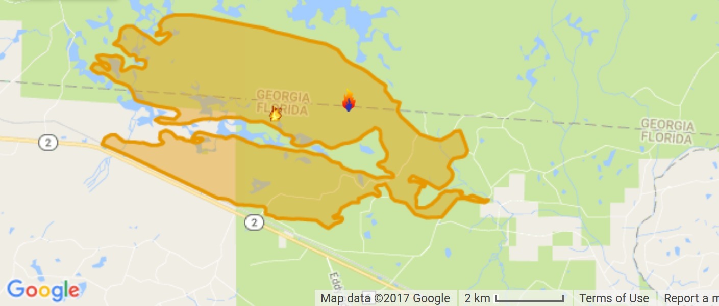
Lightning started the West Mims fire Thursday, apparently west of Moniac, Georgia in Baker County, Florida. That was in the St Marys River watershed, but the fire has since expanded west and north into the upper Suwannee River watershed and Ware County, Georgia. According to today’s update from InciWeb, the Incident Information System, the fire now involves 13,000 acres and is only 3% contained. Even with 110 firefighters and a variety of equipment, the estimated containment date is two months from now: “Thursday June 15th, 2017 approx. 12:00 AM”. It is a southern fire forest, after all.

Incident Map
Map from InciWeb 2017-04-15. Approximate Location 30.574 latitude, -82.323 longitude.

It’s probably best not to go there at night, since InciWeb says: Continue reading

Vulnerability of LNG by Rail –Martin County Fire Rescue 2015-12-15

[SE Bridge Road and SE Dixie Hwy]
SE Bridge Road and SE Dixie Hwy

If you live near A1A in Martin County, you’re in the explosion zone for LNG bomb trains on Florida East Coast Rail (FECR), supplied by Sabal Trail.

Found by Cecile Scofield of Martin County:

Martin County’s Vulnerability
Analysis of
Florida East Coast Rail’s
Transportation of
Liquefied Natural Gas (LNG)

Martin County Fire Rescue
December 2015

 -jsq, John S. Quarterman, Suwannee RIVERKEEPER®

You can join this fun and work by becoming a WWALS member today!
Continue reading

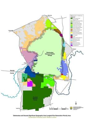
Map: Okefenokee-Osceola Longleaf Pine Restoration Priority Area

The idea is to stop wildfires coming out of the Okefenokee Swamp as they encounter a one-mile buffer Map of longleaf pine that has already had regular prescribed burns, according to Hunter Bowman, who sent this map of where the Okefenokee-Osceola Local Implementation Team works.

I live 60 miles west of that new buffer, yet I remember vividly the smoke from the 2007 fires, which even put people in the hospital farther west in Quitman, GA. All that smoke, not to mention runoff from the burned area, can’t be good for our waters.

A large image of the map is below, and PDF is on the WWALS website. As you can see, the Suwannee River above Fargo is entirely within the subject area, Continue reading