Tag Archives: Hamilton County

Agricultural land bought by west coast investors

Investment firms owned by Bill Gates have bought thousands of acress of agricultural land in counties in or near WWALS watersheds in south Georgia and north Florida, all above the Floridan Aquifer, near the Alapaha, Alapahoochee, Withlacoochee, and Suwannee Rivers, as part of a nationwide buying spree of a quarter million acres.

Here’s a summary of what we’ve found thus far. Any more recent posts should be found through this search.

These purchases of hundreds and thousands of contiguous acres are all after Bill Gates announced in 2012 he was going to “fix” agriculture in conjunction with Monsanto and Syngenta.

And it’s not just Bill Gates. Continue reading

Statenville to Sasser Landing with Turket Creek Waterfall -jsq @ WWALS 2015-02-15

It was a nice day with current on the Alapaha River from 300x180 Selfie Turket, in Statenville to Sasser Landing on the Alapaha River, by John S. Quarterman, for WWALS.net, 15 February 2015 Statenville to Sasser Landing 15 February 2015, with a side trip up the Alapahoochee River to the famous Turket Creek Waterfall. This morning WWALS continues from Sasser Landing to Jennings Bluff, plus a walk up the Dead River to the sink where the Alapaha River goes underground. Continue reading

WWALS Goals for 2015

Boating on our rivers and water trails for them, issues and education: you can help with the fun and work of WWALS! Here’s much of what can be done laid out in a list of a dozen WWALS Goals for 2015. The board has at least one opening right now, and the committees always could use more members. You can apply through the online form.

See also the monthly newsletter, the news about WWALS, and of course the website with blog, facebook the page and group, and WWALS on twitter, Youtube, and the membership google group. You can become a member or corporate sponsor of WWALS online right now.

The WWALS Executive Committee 11 March 2015 recommended Continue reading

Sasser landing to Jennings Bluff, WWALS Outing 2015-06-14

Update 2015-06-10: Expedition leader Chris Mericle writes:

I am pleased to report that the Alapaha River water level has increased since my last report (May 31). The Statenville gauge reports an increase of .9′ The Jennings gauage reports an increase of .8′. There should be plenty of water in the river for this weekend’s outing.

Float down the Alapaha River for a couple of hours, then walk to the Dead River Sink, where it disappears into the Floridan Aquifer. facebook event.

This is a pretty easy outing, but as always Continue reading

Videos: Valdosta Wastewater meeting with slides 2015-03-17

Calls from Atlanta and from downstream in Florida about the three Valdosta wastewater overflows in February prompted WWALS as the local watershed organization to contact the City of Valdosta about organizing a presentation to the interested parties. Valdosta presented less than two weeks later, and brought their entire hierarchy related to this issue, from the mayor on down. Plus Lowndes County, which isn’t even responsible for Valdosta’s wastewater, was represented by their Chairman and a Commissioner. In Valdosta’s slides and the LAKE videos of that meeting of Tuesday 17 March 2015, you can see many questions were answered, but some are still open. Continue reading

Alapaha River precipitation and levels

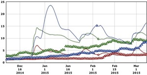
300x153 90 Days Levels Graph, in Alapaha River Levels and Precipitation, by USGS, for WWALS.net, 7 March 2015 Rainfall can be quite different in Statenville on the Alapaha River as shown here than in Valdosta on the Withlacoochee River. But remember half of Valdosta drains into the Alapaha River watershed.

Here are rainfall and water level graphs from the three USGS Alapaha River gauges in Georgia. The Florida gauge is shown separately, because it use a different base level, and precipitation doesn’t seem to be available from Florida gauges. See also always-current graphs of all the levels. Continue reading

Withlacoochee River levels follow rainfall

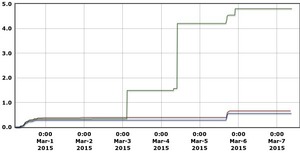
300x153 7 days Precipitation Graph, in Withlacoochee River Gauges, by NWS, for WWALS.net, 7 March 2015 Plus early March rains really were directly on Valdosta, even more than in Valdosta’s third wastewater spill of February, yet river levels rose most downstream.

Here are 90-day graphs of precipitation (in inches) and river levels (in feet) at the three Georgia Withlacoochee River gauges, from USGS. Also note river levels can continue dropping even while some new rain falls. Continue reading

Summary of Statenville to Sasser Landing WWALS Outing –Bret Wagenhorst 2015-02-15

Saw: tupelo, cypress, maple, river birch, pine, live oak, titi, mayhaw, native blueberries, palmetto; only maple in bloom. Not much wildlife.

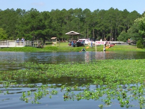
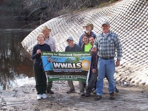
300x225 WWALS At Sasser Landing, in Sasser deanna, by Deanna Mericle, for WWALS.net, 15 February 2015 River: several small streams entered river through breaks in the bank, winding course, couple of bluffs and some exposed karst

Comments: a good level to run this section, saw 2 other canoes with a family of campers, and a fisherman in a john boat skinning a catfish, 2 rope swings, the side trip up the Alapahoochee River to the waterfall just up from the take out was worth the effort.

Pictures: see separate post by Bret Wagenhorst. And pictures by John S. Quarterman.

Ten of us met at 12 noon Sunday afternoon, February 15th 2015, continuing our exploration of the Alapaha River Water Trail, as announced.

The shuttle took Continue reading