Update 2025-10-13: better picture format, and links to the previous parts.
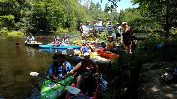
A fine fall day on the Withlacoochee River with WWALS Watershed Coalition and Suwannee Riverkeeper, diving and landowners at Arnold Springs, Old Clyattville Road Bridge, exotic invasive Japanese Climbing Fern, Horn Bridge. and Mozell Spells (State Line Ramp). Thanks to all who came to paddle from as far as two hours from Gainesville, Florida and four hours from Pine Mountain, Georgia.
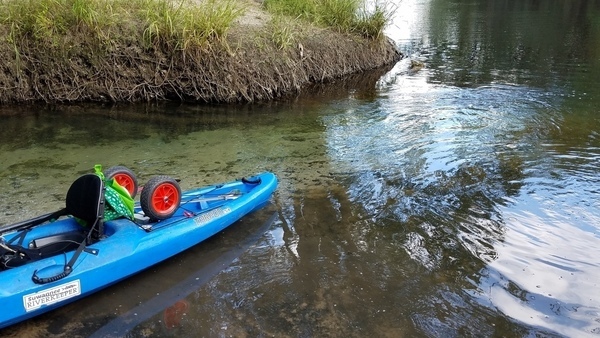
![[Clear spring water, 2017-10-14, 15:13:01, 30.6410851, -83.3367726 --jsq for WWALS]](https://www.wwals.net/pictures/2017-10-14--arnold-springs-mozell-spells-withlacoochee-river/20171014_151301.jpg)
Clear spring water, 2017-10-14, 15:13:01, –jsq for WWALS 30.6410851, -83.3367726
Blue-green Arnold Springs water meets tea-colored Withlacoochee River water.
The Quitman Gauge (US 84) read 2.17 feet (85.67 NAVD88), which was slightly above our recommended low level, and just fine for Arnold Springs. Here are some pictures and a Google Map. A few videos will follow.
This part of the outing was all in Georgia, but we paddled downstream from Florida to get there; see Continue reading
![[FGS N&R Madison Blue Spring]](https://www.wwals.net/pictures/2023-05-01--fgs-news-research/many.jpg)
![[Onwards from Hardee Spring 30.5444069, -83.2500076]](https://www.wwals.net/pictures/2015-10-24--wwals-withlacoochee/KIMG2757.jpg)
![[Pinetta Gage steps and old-style measure 30.5957374, -83.2598038]](https://www.wwals.net/pictures/2015-10-24--wwals-withlacoochee/KIMG2695.jpg)
![[WWALS at Madison Blue Spring --Gretchen Quarterman]](https://www.wwals.net/pictures/2015-10-24--wwals-withlacoochee/sign.jpg)
![[Gathering]](https://www.wwals.net/pictures/2015-10-24--wwals-withlacoochee/KIMG2691.jpg)
![[Pinetta Gage Tower 30.5957374, -83.2598038]](https://www.wwals.net/pictures/2015-10-24--wwals-withlacoochee/KIMG2694.jpg)
![[Pinetta Gage steps and old-style measure 30.5957374, -83.2598038]](https://www.wwals.net/pictures/2015-10-24--wwals-withlacoochee/small/KIMG2695.jpg)
![[Gage pipe and warning on door 30.5953369, -83.2596130]](https://www.wwals.net/pictures/2015-10-24--wwals-withlacoochee/small/KIMG2697.jpg)
![[Belleville Bridge buttress from below 30.5953369, -83.2596130]](https://www.wwals.net/pictures/2015-10-24--wwals-withlacoochee/KIMG2696.jpg)
![[Remains of Belleville Bridge, Madison County side 30.5957298, -83.2596435]](https://www.wwals.net/pictures/2015-10-24--wwals-withlacoochee/small/KIMG2692.jpg)
![[Fallen girders of Belleville Bridge, Hamilton County side 30.5956020, -83.2597732]](https://www.wwals.net/pictures/2015-10-24--wwals-withlacoochee/small/KIMG2698.jpg)
![[CR 150 bridge, looking upstream 30.5956955, -83.2594681]](https://www.wwals.net/pictures/2015-10-24--wwals-withlacoochee/KIMG2700.jpg)
![[Down the Withlacoochee River 30.5956001, -83.2593307]](https://www.wwals.net/pictures/2015-10-24--wwals-withlacoochee/small/KIMG2701.jpg)
![[Chris and Deanna picking up trash 30.5956001, -83.2593307]](https://www.wwals.net/pictures/2015-10-24--wwals-withlacoochee/small/KIMG2702.jpg)
![[Shoals 30.5941982, -83.2590637]](https://www.wwals.net/pictures/2015-10-24--wwals-withlacoochee/KIMG2705.jpg)
![[Movie: Shooting the rapids 30.5941982, -83.2590637 (9.6M)]](https://www.wwals.net/pictures/2015-10-24--wwals-withlacoochee/small/KVID2706.jpg)
![[Smooth water 30.5842590, -83.2621613]](https://www.wwals.net/pictures/2015-10-24--wwals-withlacoochee/small/KIMG2707.jpg)
![[Gretchen and the boaters 30.5822926, -83.2627106]](https://www.wwals.net/pictures/2015-10-24--wwals-withlacoochee/KIMG2708.jpg)
![[More shoals 30.5819988, -83.2626953]](https://www.wwals.net/pictures/2015-10-24--wwals-withlacoochee/KIMG2710.jpg)
![[Starting the rapids 30.5819034, -83.2627106]](https://www.wwals.net/pictures/2015-10-24--wwals-withlacoochee/small/KIMG2711.jpg)
![[Not bad 30.5819054, -83.2627029]](https://www.wwals.net/pictures/2015-10-24--wwals-withlacoochee/small/KIMG2712.jpg)
![[Ripples 30.5814247, -83.2629699]](https://www.wwals.net/pictures/2015-10-24--wwals-withlacoochee/small/KIMG2713.jpg)
![[Coffee Spring 30.5775184, -83.2618179]](https://www.wwals.net/pictures/2015-10-24--wwals-withlacoochee/KIMG2714.jpg)
![[Boating in the spring 30.5775299, -83.2618256]](https://www.wwals.net/pictures/2015-10-24--wwals-withlacoochee/small/KIMG2715.jpg)
![[Another spring? 30.5776119, -83.2620239]](https://www.wwals.net/pictures/2015-10-24--wwals-withlacoochee/small/KIMG2717.jpg)
![[Froth 30.5762119, -83.2609482]](https://www.wwals.net/pictures/2015-10-24--wwals-withlacoochee/KIMG2718.jpg)
![[Sunbeams on Chris and Deanna Mericle 30.5761909, -83.2609329]](https://www.wwals.net/pictures/2015-10-24--wwals-withlacoochee/small/KIMG2719.jpg)
![[Sighting the rapids 30.5697098, -83.2624817]](https://www.wwals.net/pictures/2015-10-24--wwals-withlacoochee/KIMG2720.jpg)
![[Boater 30.5698356, -83.2623672]](https://www.wwals.net/pictures/2015-10-24--wwals-withlacoochee/small/KIMG2721.jpg)
![[Two directions 30.5679722, -83.2606277]](https://www.wwals.net/pictures/2015-10-24--wwals-withlacoochee/KIMG2722.jpg)
![[Onwards 30.5678921, -83.2606430]](https://www.wwals.net/pictures/2015-10-24--wwals-withlacoochee/small/KIMG2723.jpg)
![[Island, or rather eyott? 30.5653133, -83.2575378]](https://www.wwals.net/pictures/2015-10-24--wwals-withlacoochee/KIMG2730.jpg)
![[Rock bottom]](https://www.wwals.net/pictures/2015-10-24--wwals-withlacoochee/small/KIMG2731.jpg)
![[The other side of the island]](https://www.wwals.net/pictures/2015-10-24--wwals-withlacoochee/small/KIMG2732.jpg)
![[Movie: Sand and rocks 30.5653133, -83.2575378 (12M)]](https://www.wwals.net/pictures/2015-10-24--wwals-withlacoochee/small/KVID2733.jpg)
![[Fossils for lunch 30.5626812, -83.2563248]](https://www.wwals.net/pictures/2015-10-24--wwals-withlacoochee/KIMG2734.jpg)
![[A prehistoric scraper 30.5626812, -83.2563248]](https://www.wwals.net/pictures/2015-10-24--wwals-withlacoochee/small/KIMG2735.jpg)
![[House 30.5626812, -83.2563248]](https://www.wwals.net/pictures/2015-10-24--wwals-withlacoochee/KIMG2737.jpg)
![[Island on left 30.5626812, -83.2563248]](https://www.wwals.net/pictures/2015-10-24--wwals-withlacoochee/KIMG2738.jpg)
![[Onwards 30.5626812, -83.2563248]](https://www.wwals.net/pictures/2015-10-24--wwals-withlacoochee/small/KIMG2740.jpg)
![[Confab 30.5626812, -83.2563248]](https://www.wwals.net/pictures/2015-10-24--wwals-withlacoochee/KIMG2741.jpg)
![[Could that be karst? 30.5529404, -83.2608642]](https://www.wwals.net/pictures/2015-10-24--wwals-withlacoochee/small/KIMG2742.jpg)
![[White water 30.5529365, -83.2608795]](https://www.wwals.net/pictures/2015-10-24--wwals-withlacoochee/KIMG2743.jpg)
![[Somebody following me 30.5509796, -83.2578125]](https://www.wwals.net/pictures/2015-10-24--wwals-withlacoochee/small/KIMG2744.jpg)
![[Spring coming up 30.5446434, -83.2505264]](https://www.wwals.net/pictures/2015-10-24--wwals-withlacoochee/KIMG2745.jpg)
![[Hardee Spring dam 30.5446434, -83.2505264]](https://www.wwals.net/pictures/2015-10-24--wwals-withlacoochee/KIMG2747.jpg)
![[Hardee Spring sign 30.5446434, -83.2505264]](https://www.wwals.net/pictures/2015-10-24--wwals-withlacoochee/small/KIMG2749.jpg)
![[Hardee Spring steps 30.5446434, -83.2505264]](https://www.wwals.net/pictures/2015-10-24--wwals-withlacoochee/small/KIMG2750.jpg)
![[Hardee Spring cavern goes through to a karst window, 30.544662, -83.250057]](https://www.wwals.net/pictures/2015-10-24--wwals-withlacoochee/small/KIMG2752.jpg)
![[KIMG2754 Looking out from Hardee Spring 30.5444069, -83.2500076]](https://www.wwals.net/pictures/2015-10-24--wwals-withlacoochee/small/KIMG2754.jpg)
![[Dan and the rock tree 30.5336761, -83.2483062]](https://www.wwals.net/pictures/2015-10-24--wwals-withlacoochee/KIMG2761.jpg)
![[Dan and the portrait rock tree 30.5337314, -83.2483062]](https://www.wwals.net/pictures/2015-10-24--wwals-withlacoochee/small/KIMG2762.jpg)
![[A boat at a bend in the river 30.5337410, -83.2490692]](https://www.wwals.net/pictures/2015-10-24--wwals-withlacoochee/small/KIMG2763.jpg)
![[A net of roots 30.5188904, -83.2391357]](https://www.wwals.net/pictures/2015-10-24--wwals-withlacoochee/small/KIMG2768.jpg)
![[Clouds 30.5188904, -83.2391357]](https://www.wwals.net/pictures/2015-10-24--wwals-withlacoochee/small/KIMG2769.jpg)
![[Undercut caves 30.5118561, -83.2455368]](https://www.wwals.net/pictures/2015-10-24--wwals-withlacoochee/KIMG2770.jpg)
![[A boat ramp 30.5118217, -83.2455063]](https://www.wwals.net/pictures/2015-10-24--wwals-withlacoochee/KIMG2771.jpg)
![[Shirley Kokidko 30.4990539, -83.2425766]](https://www.wwals.net/pictures/2015-10-24--wwals-withlacoochee/small/KIMG2772.jpg)
![[Interesting black rocks 30.4932423, -83.2414474]](https://www.wwals.net/pictures/2015-10-24--wwals-withlacoochee/KIMG2774.jpg)
![[Rocks on bank 30.4932537, -83.2414703]](https://www.wwals.net/pictures/2015-10-24--wwals-withlacoochee/small/KIMG2775.jpg)
![[Rocks from the river 30.4929829, -83.2421799]](https://www.wwals.net/pictures/2015-10-24--wwals-withlacoochee/small/KIMG2776.jpg)
![[Tall rock: petrified tree? 30.4919090, -83.2447128]](https://www.wwals.net/pictures/2015-10-24--wwals-withlacoochee/small/KIMG2777.jpg)
![[A familiar shape 30.4918537, -83.2448120]](https://www.wwals.net/pictures/2015-10-24--wwals-withlacoochee/small/KIMG2778.jpg)
![[Horizontal rocks 30.4918537, -83.2448120]](https://www.wwals.net/pictures/2015-10-24--wwals-withlacoochee/small/KIMG2779.jpg)
![[Rapids 30.4910717, -83.2443161]](https://www.wwals.net/pictures/2015-10-24--wwals-withlacoochee/KIMG2780.jpg)
![[Shirley and Dan 30.4910507, -83.2443466]](https://www.wwals.net/pictures/2015-10-24--wwals-withlacoochee/small/KIMG2781.jpg)
![[Shoals ahead 30.4910946, -83.2444839]](https://www.wwals.net/pictures/2015-10-24--wwals-withlacoochee/small/KIMG2782.jpg)
![[Shoals behind 30.4903641, -83.2442551]](https://www.wwals.net/pictures/2015-10-24--wwals-withlacoochee/small/KIMG2783.jpg)
![[More rocks 30.4902477, -83.2441711]](https://www.wwals.net/pictures/2015-10-24--wwals-withlacoochee/small/KIMG2784.jpg)
![[Karst tree 30.4899406, -83.2438965]](https://www.wwals.net/pictures/2015-10-24--wwals-withlacoochee/KIMG2785.jpg)
![[Narrow 30.4899750, -83.2439499]](https://www.wwals.net/pictures/2015-10-24--wwals-withlacoochee/small/KIMG2786.jpg)
![[Smooth 30.4863148, -83.2434845]](https://www.wwals.net/pictures/2015-10-24--wwals-withlacoochee/small/KIMG2787.jpg)
![[Two boats behind 30.4863338, -83.2434616]](https://www.wwals.net/pictures/2015-10-24--wwals-withlacoochee/small/KIMG2788.jpg)
![[Green bank, white bird 30.4822121, -83.2433777]](https://www.wwals.net/pictures/2015-10-24--wwals-withlacoochee/KIMG2790.jpg)
![[Bird flying 30.4822121, -83.2433777]](https://www.wwals.net/pictures/2015-10-24--wwals-withlacoochee/small/KIMG2791.jpg)
![[FL 6 bridge from downstream 30.4812660, -83.2434616]](https://www.wwals.net/pictures/2015-10-24--wwals-withlacoochee/KIMG2794.jpg)
![[Movie: Nearing the goal 30.4822121, -83.2433777 (6.7M)]](https://www.wwals.net/pictures/2015-10-24--wwals-withlacoochee/small/KVID2792.jpg)
![[Movie: Bridge1 30.4822121, -83.2433777 (16M)]](https://www.wwals.net/pictures/2015-10-24--wwals-withlacoochee/small/KVID2793.jpg)
![[Movie: Bridge2 30.4822121, -83.2433777 (19M)]](https://www.wwals.net/pictures/2015-10-24--wwals-withlacoochee/small/KVID2794.jpg)
![[Just around those logs 30.4810009, -83.2436981]](https://www.wwals.net/pictures/2015-10-24--wwals-withlacoochee/KIMG2797.jpg)
![[Madison Blue Spring 30.4809627, -83.2436676]](https://www.wwals.net/pictures/2015-10-24--wwals-withlacoochee/small/KIMG2800.jpg)
![[Banners, Alapahoochee River, Deadfall, Beatty Bridge, Devil Shoal, Turket Creek Waterfall]](https://www.wwals.net/pictures/2021-06-05--alapahoochee-pictures/2021-06-05--many.jpg)
![[DRAFT Areas of Opportunity, 4/6/2016]](https://www.wwals.net/pictures/2019-01-15--marion-co-fl-ear-amendment/06052018-MCBOCC-RESOLUTION-Rejecting-Alternative-Corridors-Proposed-for-Coastal-Connector-0005.jpg)